File:Map of 1926 proposal for Boston rapid transit lines.png
Original file (3,405 × 2,193 pixels, file size: 12.88 MB, MIME type: image/png)
Captions
Captions
Summary
[edit]| Description |
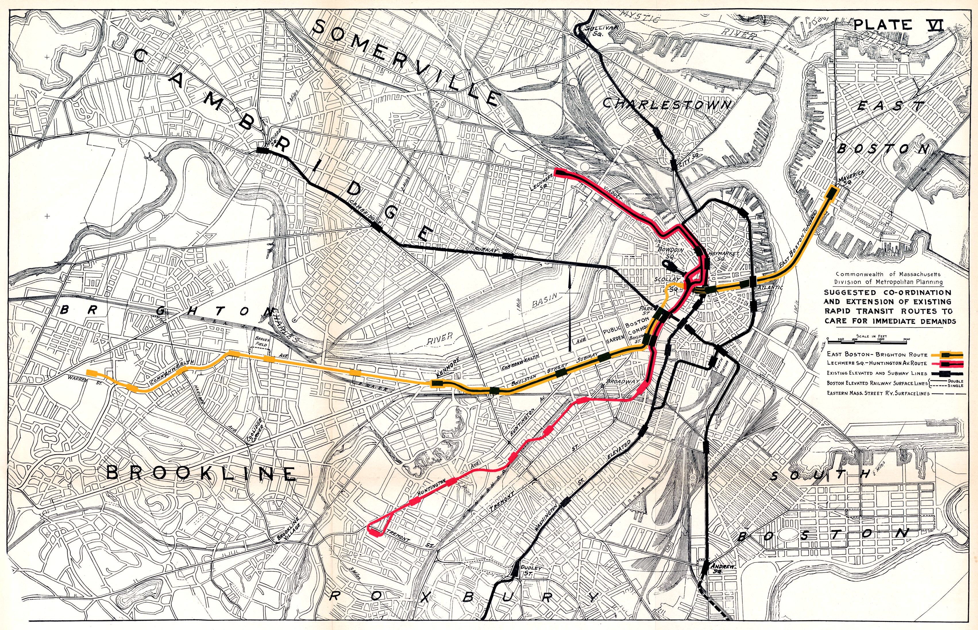
English: Plate VI of the 1926 Report on Improved Transportation Facilities in Boston, showing the proposed conversion of the existing Tremont Street Subway into two rapid transit lines. |
| Date | |
| Source | Map scan from Boston in Transit |
| Author | Division of Metropolitan Planning |
Licensing
[edit]This image is in the public domain because it is a mere mechanical scan or photocopy of a public domain original, or – from the available evidence – is so similar to such a scan or photocopy that no copyright protection can be expected to arise. The original itself is in the public domain for the following reason:
This tag is designed for use where there may be a need to assert that any enhancements (eg brightness, contrast, colour-matching, sharpening) are in themselves insufficiently creative to generate a new copyright. It can be used where it is unknown whether any enhancements have been made, as well as when the enhancements are clear but insufficient. For known raw unenhanced scans you can use an appropriate {{PD-old}} tag instead. For usage, see Commons:When to use the PD-scan tag.  |
This work is in the public domain in the United States because it was a Commonwealth of Massachusetts public record disseminated by a Commonwealth agency or the Massachusetts Archives. Massachusetts' Secretary of the Commonwealth has stated that such works can be copied and used for any purpose. This copyright does not extend to those records created, received, or under the custody of municipalities by M. G. L. c. 66, § 7, unless otherwise stated, nor does this apply to copy-written materials for commercial purposes received by employees of the Commonwealth.
Language describing permissions
A Guide to the Massachusetts Public Records Law, Published by William Francis Galvin, Secretary of the Commonwealth Division of Public Records, (Updated January 2017) can be found at https://www.mass.gov/files/2017-06/Public%20Records%20Law.pdf and page 7 says:
Definition of "public record"
Public records are defined in A Guide to the Massachusetts Public Records Law, Published by William Francis Galvin, Secretary of the Commonwealth Division of Public Records, (Updated January 2017) at https://www.mass.gov/files/2017-06/Public%20Records%20Law.pdf on page 40, under M. G. L. c. 4, § 7(26) as:
Limitations of template usage
This is consistent with the statement at http://www.sec.state.ma.us/ARC/arcres/residx.htm:
Note: Works that are considered "public records" but were not created by a state or municipal government agency may be copyrighted by their author; the Supremacy Clause of the United States Constitution prevents state law from overriding the author's right to copyright protection that is granted by federal law. For example, a state agency may post images online of the final appearance of a building under construction; while the images may be "public records", their creator (eg. architecture/construction firm) retains copyright rights to the image unless the contract with the agency says otherwise. See: Government-in-the-Sunshine Manual: To what extent does federal law preempt state law regarding public inspection of records?. |

|

File history
Click on a date/time to view the file as it appeared at that time.
| Date/Time | Thumbnail | Dimensions | User | Comment | |
|---|---|---|---|---|---|
| current | 18:22, 8 July 2020 | | 3,405 × 2,193 (12.88 MB) | Pi.1415926535 (talk | contribs) | white balance |
| 22:51, 17 December 2018 |  | 3,500 × 2,301 (16.07 MB) | Pi.1415926535 (talk | contribs) | full size | |
| 07:15, 17 December 2018 |  | 955 × 611 (1.13 MB) | Pi.1415926535 (talk | contribs) | {{Information |description ={{en|1=Plate VI of the 1926 [https://hdl.handle.net/2027/mdp.39015049422689 Report on Improved Transportation Facilities in Boston], showing the proposed conversion of the existing Tremont Street Subway into two rapid transit lines.}}}} |date =1926-12 |source =Map scan from [https://www.wardmaps.com/viewasset.php?aid=18896 Ward Maps] |author =Division of Metropolitan Planning |permission ={{PD-scan|PD-US-no notice}}{{PD-scan|PD... |
You cannot overwrite this file.
File usage on Commons
The following 7 pages use this file:
- User:Chumwa/OgreBot/Potential transport maps/2018 December 11-20
- User:Chumwa/OgreBot/Public transport information/2018 December 11-20
- User:Chumwa/OgreBot/Public transport information/2020 July 1-10
- User:Chumwa/OgreBot/Transport Maps/2018 December 11-20
- User:Chumwa/OgreBot/Transport Maps/2020 July 1-10
- User:Chumwa/OgreBot/Travel and communication maps/2018 December 11-20
- User:Chumwa/OgreBot/Travel and communication maps/2020 July 1-10
File usage on other wikis
The following other wikis use this file:
- Usage on en.wikipedia.org
- Usage on zh.wikipedia.org