File:Map indicating Ellesmere Island, Nunavut, Canada.png
Jump to navigation
Jump to search
No higher resolution available.
Map_indicating_Ellesmere_Island,_Nunavut,_Canada.png (428 × 380 pixels, file size: 56 KB, MIME type: image/png)
Captions
Captions
Add a one-line explanation of what this file represents
Summary
[edit]
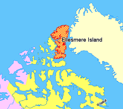
Map indicating Ellesmere Island, Nunavut, Canada.
Nunavut
Northwest Territories
Greenland
© Her Majesty the Queen in Right of Canada, Department of Natural Resources. All rights reserved.
Licence Agreement
Licensing
[edit]

|
The copyright holder of this work allows anyone to use it for any purpose including unrestricted redistribution, commercial use, and modification.
Usage notes:
|
File history
Click on a date/time to view the file as it appeared at that time.
| Date/Time | Thumbnail | Dimensions | User | Comment | |
|---|---|---|---|---|---|
| current | 10:46, 21 March 2006 | | 428 × 380 (56 KB) | David Kernow~commonswiki (talk | contribs) | Map indicating Ellesmere Island, Nunavut, Canada. {{legend|#ffff66|Nunavut}} {{legend|#ffccff|Northwest Territories}} {{legend|#ffffcc|Greenland}} <br> © Her Majesty the Queen in Right of Canada, Department of Natural Resource |
You cannot overwrite this file.
File usage on Commons
The following page uses this file:
File usage on other wikis
The following other wikis use this file:
- Usage on ast.wikipedia.org
- Usage on es.wikipedia.org
- Usage on fr.wikinews.org
- Usage on gl.wikipedia.org
- Usage on he.wikipedia.org
- Usage on it.wikipedia.org
- Usage on sv.wikipedia.org
- Usage on tr.wikipedia.org