File:Map illustrating the operations of U.S. Forces against Vicksburg LOC 86691335.jpg
Jump to navigation
Jump to search

Size of this preview: 498 × 600 pixels. Other resolutions: 199 × 240 pixels | 399 × 480 pixels | 638 × 768 pixels | 850 × 1,024 pixels | 1,701 × 2,048 pixels | 5,263 × 6,338 pixels.
Original file (5,263 × 6,338 pixels, file size: 3.51 MB, MIME type: image/jpeg)
Captions
Captions
Add a one-line explanation of what this file represents
Summary
[edit]| Description |
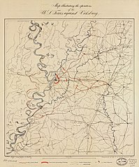
English: LC copy annotated in pencil on verso: Map illustrating operations against Vicksburg, [1863?]. Also shows the tracks of Genl. Grant, General Blair, and Admiral Porter, and sites of Union victories. Relief shown by hachures. From the Joseph R. Hawley papers in LC Manuscript Division. LC Civil War maps (2nd ed.) 289.5 Available also through the Library of Congress Web site as a raster image. |
||
| Title | Map illustrating the operations of U.S. Forces against Vicksburg | ||
| Shelf ID | G3984.V8S5 1863 .U51 | ||
| Date | |||
| Source | https://www.loc.gov/item/86691335/ | ||
| Author | United States Coast Survey; Maedel, J. W.; Hawley, Joseph R. (Joseph Roswell) | ||
| Permission (Reusing this file) |
|
||
| Other versions |
|
||
| Location | United States · Vicksburg Region · Mississippi | ||
| Part of | Military Battles And Campaigns · American Memory · Civil War Maps · Catalog · Geography And Map Division | ||
| Subject | Mississippi · Maps · Vicksburg Region · Civil War · United States · Vicksburg Region (Miss.) · History |


Licensing
[edit]
|
This is a faithful photographic reproduction of a two-dimensional, public domain work of art. The work of art itself is in the public domain for the following reason:
The official position taken by the Wikimedia Foundation is that "faithful reproductions of two-dimensional public domain works of art are public domain".
This photographic reproduction is therefore also considered to be in the public domain in the United States. In other jurisdictions, re-use of this content may be restricted; see Reuse of PD-Art photographs for details. | ||||
File history
Click on a date/time to view the file as it appeared at that time.
| Date/Time | Thumbnail | Dimensions | User | Comment | |
|---|---|---|---|---|---|
| current | 07:14, 18 May 2018 | | 5,263 × 6,338 (3.51 MB) | Fæ (talk | contribs) | LOC Maps https://www.loc.gov/item/86691335/ #10621 |
You cannot overwrite this file.
File usage on Commons
The following page uses this file: