File:Map boatlifts canal du centre.svg
Jump to navigation
Jump to search

Size of this PNG preview of this SVG file: 534 × 375 pixels. Other resolutions: 320 × 225 pixels | 640 × 449 pixels | 1,024 × 719 pixels | 1,280 × 899 pixels | 2,560 × 1,798 pixels.
Original file (SVG file, nominally 534 × 375 pixels, file size: 418 KB)
Captions
Captions
Add a one-line explanation of what this file represents
Summary
[edit]
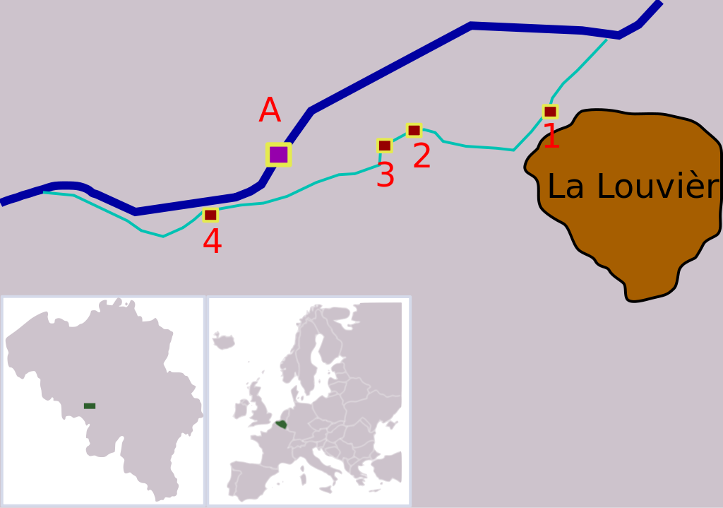
| Description | Map showing the locations of the four boatlifts on Canal du Centre, Belgium. The boatlifts are a UNESCO world heritage site. The numbers correspond with the UNESCO inscription, "A" is the new boatlift that replaced them. |
| Date | |
| Source |
Own work This W3C-unspecified vector image was created with Inkscape . |
| Author | Finnrind |
Licensing
[edit]
I, Finnrind, the copyright holder of this work, hereby publishes it under the following licenses:

|
Permission is granted to copy, distribute and/or modify this document under the terms of the GNU Free Documentation License, Version 1.2 or any later version published by the Free Software Foundation; with no Invariant Sections, no Front-Cover Texts, and no Back-Cover Texts. A copy of the license is included in the section entitled GNU Free Documentation License. |
| This file is licensed under the Creative Commons Attribution-Share Alike 3.0 Unported license. | ||
| Attribution: I, Finnrind | ||
| ||
| This licensing tag was added to this file as part of the GFDL licensing update. |
This file is licensed under the Creative Commons Attribution-Share Alike 2.5 Generic, 2.0 Generic and 1.0 Generic license.
Attribution: I, Finnrind
- You are free:
- to share – to copy, distribute and transmit the work
- to remix – to adapt the work
- Under the following conditions:
- attribution – You must give appropriate credit, provide a link to the license, and indicate if changes were made. You may do so in any reasonable manner, but not in any way that suggests the licensor endorses you or your use.
- share alike – If you remix, transform, or build upon the material, you must distribute your contributions under the same or compatible license as the original.
You may select the license of your choice.
File history
Click on a date/time to view the file as it appeared at that time.
| Date/Time | Thumbnail | Dimensions | User | Comment | |
|---|---|---|---|---|---|
| current | 19:08, 15 July 2007 | | 534 × 375 (418 KB) | Finnrind (talk | contribs) | |
| 18:31, 15 July 2007 |  | 534 × 375 (412 KB) | Finnrind (talk | contribs) | ||
| 18:25, 15 July 2007 |  | 534 × 375 (412 KB) | Finnrind (talk | contribs) | ||
| 18:21, 15 July 2007 |  | 258 × 183 (151 KB) | Finnrind (talk | contribs) | {{Information |Description=Map showing the locations of the four boatlifts on Canal du Centre, Belgium. The boatlifts are a UNESCO world heritage site. The numbers correspond with the UNESCO inscription, "A" is the new boatlift that replaced them. |Source |
You cannot overwrite this file.
File usage on Commons
There are no pages that use this file.
File usage on other wikis
The following other wikis use this file:
- Usage on ca.wikipedia.org
- Usage on de.wikipedia.org
- Usage on en.wikipedia.org
- Usage on eo.wikipedia.org
- Usage on es.wikipedia.org
- Usage on fi.wikipedia.org
- Usage on fr.wikipedia.org
- Usage on gl.wikipedia.org
- Usage on he.wikipedia.org
- Usage on hr.wikipedia.org
- Usage on hu.wikipedia.org
- Usage on lt.wikipedia.org
- Usage on mt.wikipedia.org
- Usage on nl.wikipedia.org
- Usage on no.wikipedia.org
- Usage on pl.wikipedia.org
- Usage on pt.wikipedia.org
- Usage on ro.wikipedia.org
- Usage on ru.wikipedia.org
- Usage on sh.wikipedia.org
- Usage on sr.wikipedia.org
- Usage on zh.wikipedia.org