File:Map Widerøe Flight 933.png
Map_Widerøe_Flight_933.png (562 × 332 pixels, file size: 159 KB, MIME type: image/png)
Captions
Captions
| Description |
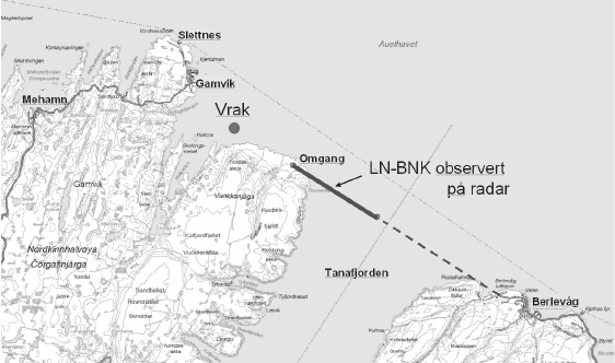
English: Map of the flight path of Widerøe Flight 933. The thick line is the part observed by radar; "vrak" marks the location of the wreck.
Norsk bokmål: Banen til WF933 (Mehamn-ulykken). Den tykke linjen er det som er fulgt på radar. |
| Date | |
| Source |
[http://www.stortinget.no/Global/pdf/Dokumentserien/2004-2005/dok24-200405.pdf Rapport til Stortingets presidentskap fra Stortingets granskningskommisjon for Mehamn-ulykken] |
| Author | Parliament of Norway |
| This file is in the public domain because legal statutes, administrative regulations, court decisions and other decisions by public authorities are unprotected. This is also the case with proposals, reports and other statements which concern the public exercise of authority, and which are made by a public authority, a publicly appointed council or committee, or published by the public authorities. Similarly, official translations of such texts are unprotected. Intellectual works ("åndsverk" as defined in § 2) which have not been produced specially for use in documents specified in the first paragraph, and from which parts are quoted or which are reproduced in a separate appendix, are not covered by this provision. The same apply to poetry, musical compositions or works of art.
|
 |
File history
Click on a date/time to view the file as it appeared at that time.
| Date/Time | Thumbnail | Dimensions | User | Comment | |
|---|---|---|---|---|---|
| current | 08:03, 21 October 2012 | | 562 × 332 (159 KB) | Arsenikk (talk | contribs) | {{Information |Description={{en|Map of the flight path of Widerøe Flight 933. The thick line is the part observed by radar; "vrak" marks the location of the wreck.}} {{no|Banen til WF933 (Mehamn-ulykken). Den tykke linjen er det som er fulgt på radar... |
You cannot overwrite this file.
File usage on Commons
The following page uses this file:
File usage on other wikis
The following other wikis use this file:
- Usage on de.wikipedia.org
- Usage on en.wikipedia.org
- Usage on fi.wikipedia.org
- Usage on nn.wikipedia.org
- Usage on no.wikipedia.org