File:Map Whitehall.png
Jump to navigation
Jump to search
No higher resolution available.
Map_Whitehall.png (300 × 569 pixels, file size: 135 KB, MIME type: image/png)
Captions
Captions
Add a one-line explanation of what this file represents
Summary
[edit]
| Description |
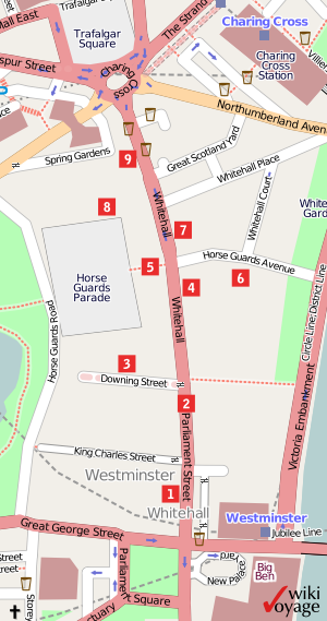
English: Map of Whitehall with major tourist attractions. |
| Date | 13 January 2009 (original upload date) |
| Source | openstreetmap.org |
| Creator |
User: Africaspotter at wikivoyage shared OpenStreetMap contributors |
| Permission (Reusing this file) |
OpenStreetMap data and maps are licensed under the Creative Commons Attribution-ShareAlike 2.0 license (CC-BY-SA 2.0). This file is licensed under the Creative Commons Attribution-Share Alike 2.0 Generic license.
|
| Georeferencing | If inappropriate please set warp_status = skip to hide. |
Original upload log
[edit]
| This file was imported from Wikivoyage Shared. |
The original description page was here. All following user names refer to wikivoyage-old/shared.
- 2009-01-15 18:45 Africaspotter archive copy at the Wayback Machine 300×569 (138632 bytes) == Summary == {{Information |Description=Map of Whitehall with major tourist attractions. |Author=[[User:Africaspotter|Africaspotter]] |Date=13/January/2009 |Source=self-made with map by openstreetmap.org |Permission=See below |other_versions= }} [[Category:London/City of Westminster]]
File history
Click on a date/time to view the file as it appeared at that time.
| Date/Time | Thumbnail | Dimensions | User | Comment | |
|---|---|---|---|---|---|
| current | 21:58, 16 December 2012 | | 300 × 569 (135 KB) | MGA73bot2 (talk | contribs) | {{BotMoveToCommons|shared.oldwikivoyage|year={{subst:CURRENTYEAR}}|month={{subst:CURRENTMONTHNAME}}|day={{subst:CURRENTDAY}}}} == {{int:filedesc}} == {{Information |description=Map of Whitehall with major tourist attractions. |date=13/January/2009 |sou... |
You cannot overwrite this file.
File usage on Commons
There are no pages that use this file.
File usage on other wikis
The following other wikis use this file:
- Usage on de.wikivoyage.org