File:Map West-Africa 1 250,000 Mopti - ND-306 Series G504 Edition 1-AMS - U.S. Army Corps of Engineers Army Map Service, 1954.jpg
Jump to navigation
Jump to search

Size of this preview: 789 × 599 pixels. Other resolutions: 316 × 240 pixels | 632 × 480 pixels | 1,011 × 768 pixels | 1,280 × 972 pixels | 2,560 × 1,945 pixels | 5,000 × 3,798 pixels.
Original file (5,000 × 3,798 pixels, file size: 4.04 MB, MIME type: image/jpeg)
Captions
Captions
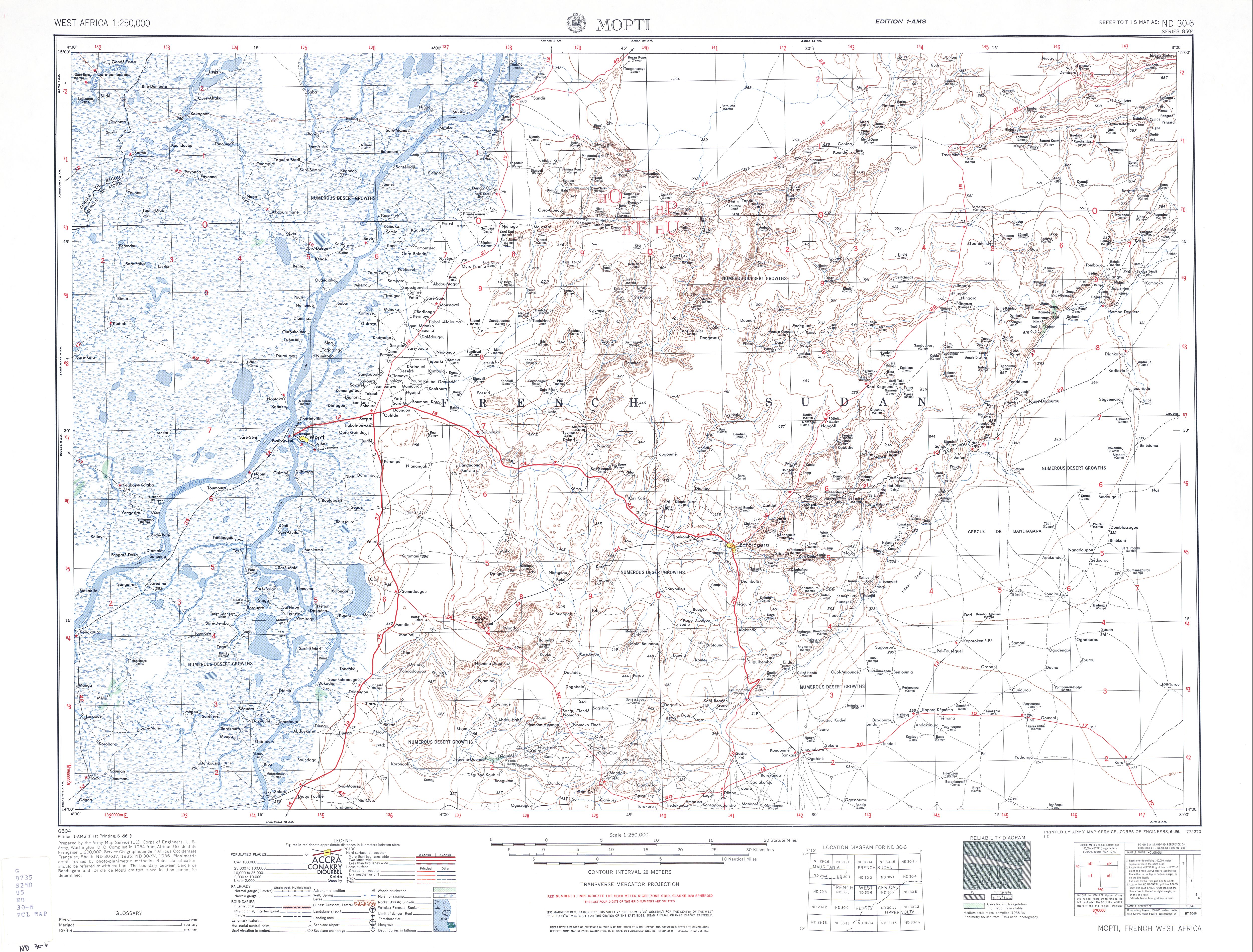
Map West-Africa 1 250,000 Mopti. ND-306. U.S. Army Corps of Engineers, 1954.
Summary
[edit]| Description |
Nederlands: Landkaart West-Africa 1:250,000 Mopti - ND-306 Series G504 Edition 1-AMS - U.S. Army Corps of Engineers Army Map Service, 1954. In dank op internet opgehaald bij de Perry-Castañeda Library Map Collection, University of Texas Libraries, University of Texas at Austin.
English: Map West-Africa 1:250,000 Mopti - ND-306 Series G504 Edition 1-AMS. U.S. Army Corps of Engineers Army Map Service, 1954. Gratefully downloaded from: Perry-Castañeda Library Map Collection, University of Texas Libraries, University of Texas at Austin.
Français : Carte Afrique de l'Ouest 1: 250 000 Mopti - Série ND-306 G504 Edition 1-AMS. US Army Corps of Engineers Army Map Service, 1954. Téléchargé avec gratitude de: Perry-Castañeda Library Map Collection, University of Texas Libraries, University of Texas at Austin. |
| Date | |
| Source | U.S. Army Corps of Engineers Army Map Service legacy.lib.utexas.edu. Map "West-Africa 1:250,000 Mopti ND-306 Series G504 Edition 1-AMS" |
| Author | U.S. Army Corps of Engineers Army Map Service |
| Other versions |
.jpg)
Licensing
[edit]
This work is in the public domain in the United States because it is a work prepared by an officer or employee of the United States Government as part of that person’s official duties under the terms of Title 17, Chapter 1, Section 105 of the US Code.
Note: This only applies to original works of the Federal Government and not to the work of any individual U.S. state, territory, commonwealth, county, municipality, or any other subdivision. This template also does not apply to postage stamp designs published by the United States Postal Service since 1978. (See § 313.6(C)(1) of Compendium of U.S. Copyright Office Practices). It also does not apply to certain US coins; see The US Mint Terms of Use.
|
 | |
| This file has been identified as being free of known restrictions under copyright law, including all related and neighboring rights. | ||
File history
Click on a date/time to view the file as it appeared at that time.
| Date/Time | Thumbnail | Dimensions | User | Comment | |
|---|---|---|---|---|---|
| current | 10:04, 6 March 2021 | | 5,000 × 3,798 (4.04 MB) | Hansmuller (talk | contribs) | Uploaded a work by U.S. Army Corps of Engineers Army Map Service from [https://legacy.lib.utexas.edu/maps/ams/west_africa/txu-oclc-6595921-nd30-6.jpg U.S. Army Corps of Engineers Army Map Service legacy.lib.utexas.edu]. Map "West-Africa 1:250,000 Mopti ND-306 Series G504 Edition 1-AMS" with UploadWizard |
You cannot overwrite this file.
File usage on Commons
The following page uses this file: