File:Map Staten Island Railway de.png
Jump to navigation
Jump to search

Size of this preview: 651 × 600 pixels. Other resolutions: 260 × 240 pixels | 521 × 480 pixels | 833 × 768 pixels | 1,111 × 1,024 pixels | 1,885 × 1,737 pixels.
Original file (1,885 × 1,737 pixels, file size: 2.25 MB, MIME type: image/png)
Captions
Captions
Add a one-line explanation of what this file represents
| Description |
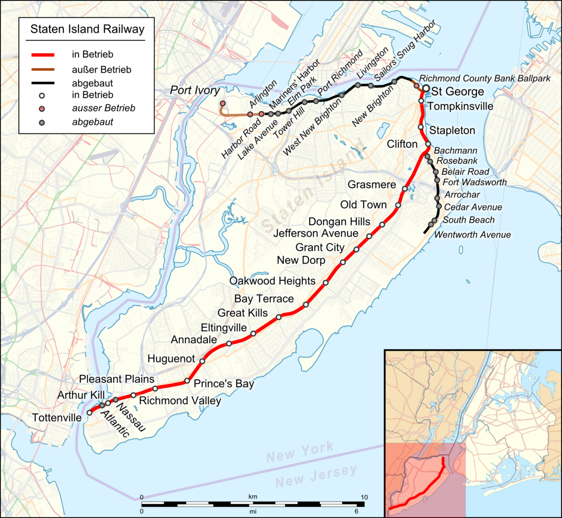
English: Location map of Staten Island Railway. German Index |
|||||||||
| Date | ||||||||||
| Source |
|
|||||||||
| Creator |
|
|||||||||
| Geotemporal data | ||||||||||
| Bounding box |
|
|||||||||
| Georeferencing | ||||||||||
| Other versions |
 |
|||||||||
I, the copyright holder of this work, hereby publish it under the following license:
This file is licensed under the Creative Commons Attribution 3.0 Unported license.
- You are free:
- to share – to copy, distribute and transmit the work
- to remix – to adapt the work
- Under the following conditions:
- attribution – You must give appropriate credit, provide a link to the license, and indicate if changes were made. You may do so in any reasonable manner, but not in any way that suggests the licensor endorses you or your use.
| This work is licensed under the Open Database License (summary). |
File history
Click on a date/time to view the file as it appeared at that time.
| Date/Time | Thumbnail | Dimensions | User | Comment | |
|---|---|---|---|---|---|
| current | 02:13, 29 April 2018 | | 1,885 × 1,737 (2.25 MB) | Pechristener (talk | contribs) | korr Atlantic and Nassau stops were demolished |
| 01:58, 29 April 2018 |  | 1,885 × 1,737 (2.25 MB) | Pechristener (talk | contribs) | Arthur Kill Station added | |
| 08:14, 22 November 2016 |  | 1,885 × 1,737 (1.57 MB) | Kopiersperre (talk | contribs) | optipng | |
| 03:43, 22 November 2016 |  | 1,885 × 1,737 (2.27 MB) | Pechristener (talk | contribs) | {{Map |Description={{en|1=Location map of {{w|Staten Island Railway}}. German Index}} |Source= * [http://www.openstreetmap.org/ Open Street Map] Data * {{f|USA_New_York_City_location_map.svg}} (for location map) |Author= * rendering with Maperitive, t... |
You cannot overwrite this file.
File usage on Commons
The following 9 pages use this file:
- User:Chumwa/OgreBot/Potential transport maps/2016 November 21-30
- User:Chumwa/OgreBot/Potential transport maps/2018 April 21-30
- User:Chumwa/OgreBot/Public transport information/2016 November 21-30
- User:Chumwa/OgreBot/Public transport information/2018 April 21-30
- User:Chumwa/OgreBot/Transport Maps/2016 November 21-30
- User:Chumwa/OgreBot/Transport Maps/2018 April 21-30
- User:Chumwa/OgreBot/Travel and communication maps/2016 November 21-30
- User:Chumwa/OgreBot/Travel and communication maps/2018 April 21-30
- File:Map Staten Island Railway en.png
File usage on other wikis
The following other wikis use this file:
- Usage on de.wikipedia.org