File:Map Potsdam 1778.jpg
Jump to navigation
Jump to search
Size of this preview: 689 × 600 pixels. Other resolutions: 276 × 240 pixels | 552 × 480 pixels | 883 × 768 pixels | 1,164 × 1,013 pixels.
Original file (1,164 × 1,013 pixels, file size: 1.03 MB, MIME type: image/jpeg)
Captions
Captions
Add a one-line explanation of what this file represents
Summary
[edit]| Stadtplan von Potsdam mit Gebäudeansichten | |
|---|---|
| Title |
Stadtplan von Potsdam mit Gebäudeansichten |
| Description |
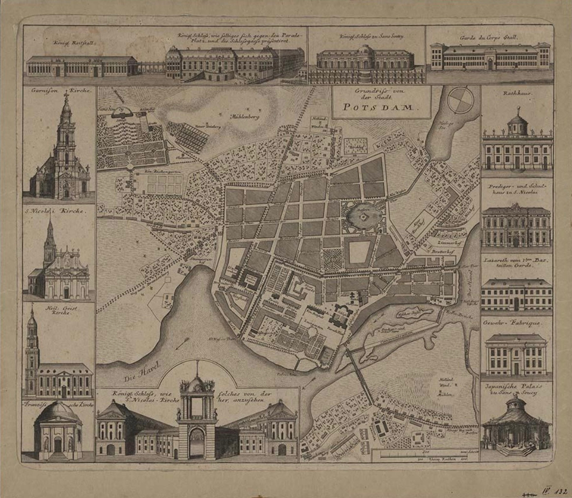
Der "Grundriss von der Stadt Potsdam" schließt neben einem Plan der Innenstadt dreizehn Gebäudeansichten wohl nach Johann David Schleuen d. Ä. (1711-1771) ein, die rings um den Stadtkern in kommentierten Aufrissen angeordnet sind. Von oben links an sind im Uhrzeigersinn angeordnet:1. Schloss-Marstall 2. Schloss Sanssouci 3. Garde du Corps Stall 4. Rathaus 5. Prediger- und Schulhaus St. Nicolai 6. Lazarett vom 1. Bataillon Garde 7. Gewehrfabrik 8. Japanisches Teehaus 9. Stadtschloss (Marktseite) 10. Französische Kirche 11. Heilig- Geist-Kirche 12. Nicolai-Kirche 13. Garnisonkirche; Maßstab: Rhein. Ruthen (3,6 cm = 100 R.-Ruthen). Der mit Veduten angereicherte Plan folgt dem 1778 von Carl Ludwig Oesfeld (1741-1804) erstmals vorgelegten Grundriss der Residenzstadt mit den beiden unter Friedrich Wilhelm I. und Friedrich II. erfolgten Stadterweiterungen (vgl. L-77-7). |
| Date | circa 1778 |
| Medium | etching print |
| Dimensions | 44 × 53 cm (17.3 × 20.8 in) |
| Accession number |
L-77-1 |
| Source/Photographer | https://brandenburg.museum-digital.de/object/3883 |
| Other versions |
|

Licensing
[edit]
|
This is a faithful photographic reproduction of a two-dimensional, public domain work of art. The work of art itself is in the public domain for the following reason:
The official position taken by the Wikimedia Foundation is that "faithful reproductions of two-dimensional public domain works of art are public domain".
This photographic reproduction is therefore also considered to be in the public domain in the United States. In other jurisdictions, re-use of this content may be restricted; see Reuse of PD-Art photographs for details. | ||||
File history
Click on a date/time to view the file as it appeared at that time.
| Date/Time | Thumbnail | Dimensions | User | Comment | |
|---|---|---|---|---|---|
| current | 19:06, 8 May 2023 | | 1,164 × 1,013 (1.03 MB) | Oursana (talk | contribs) | == {{int:filedesc}} == {{Artwork |artist = |Title = Stadtplan von Potsdam mit Gebäudeansichten |Description = Der "Grundriss von der Stadt Potsdam" schließt neben einem Plan der Innenstadt dreizehn Gebäudeansichten wohl nach Johann David Schleuen d. Ä. (1711-1771) ein, die rings um den Stadtkern in kommentierten Aufrissen angeordnet sind. Von oben links an sind im Uhrzeigersinn angeordnet:1. Schloss-Marstall 2. Schloss Sanssouci 3. Garde du Corps Stall 4. Rathaus 5. Pr... |
You cannot overwrite this file.
File usage on Commons
The following page uses this file: