File:Map Political map of Africa 1928 - Touring Club Italiano CART-TRC-11 01.jpg
Jump to navigation
Jump to search

Size of this preview: 563 × 599 pixels. Other resolutions: 226 × 240 pixels | 451 × 480 pixels | 722 × 768 pixels | 963 × 1,024 pixels | 2,459 × 2,616 pixels.
Original file (2,459 × 2,616 pixels, file size: 3.12 MB, MIME type: image/jpeg)
Captions
Captions
Add a one-line explanation of what this file represents
Summary
[edit]| Title |
Political map of Africa |
||||||||||||||||
| Description |
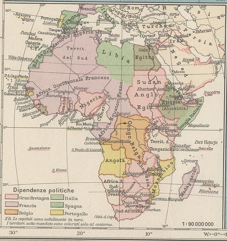
English: The map shows the political asset of the African continent after the scramble for Africa - the invasion, divisIon and colonization of most of Africa by the major European Powers at the beginning of the XX century. The colonies are represented by different colors: British colonies by pink; French colonies by violet; the Belgian ones by orange, the Italian ones by bright green; dark green stands for Spanish colonies and yellow for the Portuguese ones. The map is one of the tables made by the TCI Cartographic Office for the Italian Encyclopedia of Giovanni Treccani Institute Italiano: La carta illustra l'assetto politico del continente africano al termine della "corsa all'Africa" - l'invasione, divisione e colonizzazione della maggior parte del continente africano da parte delle maggiori potenze europee all'inizio del XX secolo. Le colonie sono rappresentate con colori diveri: il rosa indica le colonue inglesi, il violetto quelle francesi; le colonie belga sono indicate con l'arancione, quelle italiane con il verde chiaro; il verde scuro indica le colonie spagnole e il giallo quelle portoghesi. La mappa è una delle tavole realizzate dall'Ufficio Cartografico del TCI per l'Enciclopedia Italiana dell'Istituto Giovanni Treccani |
||||||||||||||||
| Date | |||||||||||||||||
| Source | Scan from the original work Archivio Storico del Touring Club Italiano | ||||||||||||||||
| Creator |
|
||||||||||||||||
| Permission (Reusing this file) |
|
||||||||||||||||
| Geotemporal data | |||||||||||||||||
| Map location | Africa | ||||||||||||||||
| Map type | Political maps - Administrative maps by continent - Maps of Africa - Maps showing history | ||||||||||||||||
| Scale | 1: 90 000 000 | ||||||||||||||||
| Georeferencing | If inappropriate please set warp_status = skip to hide. | ||||||||||||||||
| Bibliographic data | |||||||||||||||||
| Part of the series | 1° Edition Italian Encyclopedia Giovanni Treccani | ||||||||||||||||
| Language | Italian | ||||||||||||||||
| Place of publication | Milan | ||||||||||||||||
| Publisher |
TCI |
||||||||||||||||
| Printed by |
Vallardi |
||||||||||||||||
| Archival data | |||||||||||||||||
| Collection | |||||||||||||||||
| Accession number |
CART.TRC.11_01 |
||||||||||||||||

Licensing
[edit]
File history
Click on a date/time to view the file as it appeared at that time.
| Date/Time | Thumbnail | Dimensions | User | Comment | |
|---|---|---|---|---|---|
| current | 08:36, 12 October 2022 | | 2,459 × 2,616 (3.12 MB) | Ilaria Parma (TCI) (talk | contribs) | pattypan 22.03 |
You cannot overwrite this file.
File usage on Commons
The following page uses this file:
File usage on other wikis
The following other wikis use this file: