File:Map Ocean County NJ Toms River.gif
Jump to navigation
Jump to search
No higher resolution available.
Map_Ocean_County_NJ_Toms_River.gif (370 × 540 pixels, file size: 42 KB, MIME type: image/gif)
Captions
Captions
Add a one-line explanation of what this file represents
Summary
[edit]
| Description |
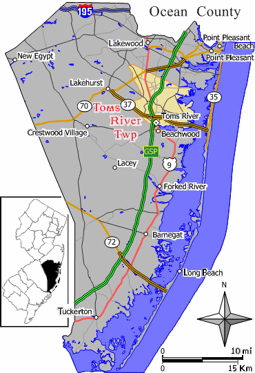
English: Closeup view of map of Toms River Township in Ocean County |
| Date | 20 August 2007 (original upload date) |
| Source | Extracted from original map work by Jim Irwin, December 2005, with distance scale in miles/kilometers, Interstate-icons enlarged 50%, town names clarified, and edges cropped 210px (width 370px had been 580px). Source (smaller Wikipedia map): Image:Dover twp nj 029.png (cropped and magnified 36%, adding kilometer scale, and enlarging names/icons). |
| Author | Wikid77 at English Wikipedia |
Licensing
[edit]
Wikid77 at the English-language Wikipedia, the copyright holder of this work, hereby publishes it under the following license:
| This file is licensed under the Creative Commons Attribution-Share Alike 3.0 Unported license. Subject to disclaimers. | ||
| Attribution: Wikid77 at the English-language Wikipedia | ||
| ||
| This licensing tag was added to this file as part of the GFDL licensing update. |

|
Permission is granted to copy, distribute and/or modify this document under the terms of the GNU Free Documentation License, Version 1.2 or any later version published by the Free Software Foundation; with no Invariant Sections, no Front-Cover Texts, and no Back-Cover Texts. A copy of the license is included in the section entitled GNU Free Documentation License. Subject to disclaimers. |
Original upload log
[edit]
Transferred from en.wikipedia to Commons by Quadell using CommonsHelper.
The original description page was here. All following user names refer to en.wikipedia.
- 2007-08-20 20:02 Wikid77 370×540× (43017 bytes) renamed "Dover Twp" to "Toms River Twp"; cut height 4% (20px); clarified town names
- 2007-08-20 14:54 Wikid77 370×560× (42933 bytes) Closeup view of map of Toms River Township in [[Ocean County, New Jersey]] (extracted from original map work by Jim Irwin, December 2005), with distance scale in miles/kilometers, Interstate-icons enlarged 50%, town names clarified, and edge
File history
Click on a date/time to view the file as it appeared at that time.
| Date/Time | Thumbnail | Dimensions | User | Comment | |
|---|---|---|---|---|---|
| current | 14:51, 11 July 2013 | | 370 × 540 (42 KB) | File Upload Bot (Magnus Manske) (talk | contribs) | Transfered from en.wikipedia by User:Quadell using CommonsHelper |
You cannot overwrite this file.
File usage on Commons
The following 2 pages use this file:
File usage on other wikis
The following other wikis use this file:
- Usage on azb.wikipedia.org
- Usage on ca.wikipedia.org
- Usage on cy.wikipedia.org
- Usage on de.wikipedia.org
- Usage on en.wikipedia.org
- Usage on fa.wikipedia.org
- Usage on fr.wikipedia.org
- Usage on ht.wikipedia.org
- Usage on hu.wikipedia.org
- Usage on ja.wikipedia.org
- Usage on sh.wikipedia.org
- Usage on sr.wikipedia.org
- Usage on vo.wikipedia.org
- Usage on www.wikidata.org
- Usage on zh-min-nan.wikipedia.org
- Usage on zh.wikipedia.org