File:Map Milne Bay to Oro Bay-Gona-Buna.png
Jump to navigation
Jump to search
Size of this preview: 800 × 490 pixels. Other resolutions: 320 × 196 pixels | 640 × 392 pixels | 1,019 × 624 pixels.
Original file (1,019 × 624 pixels, file size: 289 KB, MIME type: image/png)
Captions
Captions
Add a one-line explanation of what this file represents
Summary
[edit]
| Description |
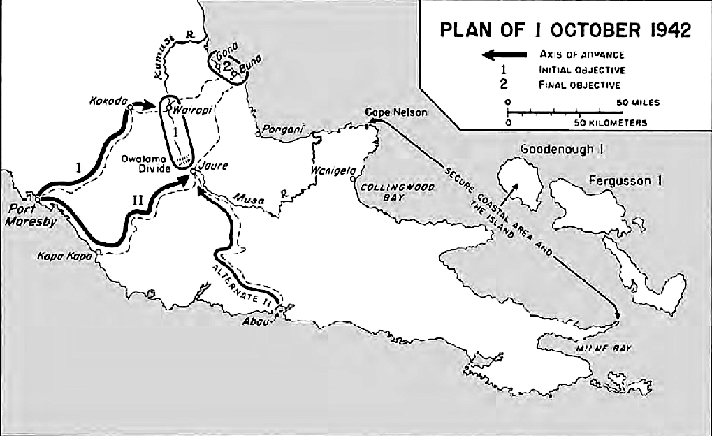
English: Map 6, Plan of 1 October 1942 showing supply lines Milne Bay to Oro Bay-Gona-Buna operations area. |
| Date | |
| Source | United States Army in World War II - Victory in Paupa. Map 6, page 101. |
| Author | U.S Army |
Licensing
[edit]
| This image is in the public domain because it contains materials that originally came from the United States Army Center of Military History, subject to the following qualification.
Note: The images of all badges, insignia, decorations and medals on the "CMH Online" web site are produced by the United States Army Institute of Heraldry and protected by Title 18, United States Code, Section 704 and the Code of Federal Regulations (32 CFR, Part 507). Permission to use these images for commercial purposes must be obtained from The Institute of Heraldry prior to their use. |

|
Original upload log
[edit]
The original description page was here. All following user names refer to en.wikipedia.
- 2013-08-18 15:27 Palmeira 1019×624× (295791 bytes) == Summary == {{Information | Description = Map 6, Plan of 1 October 1942 showing supply lines Milne Bay to Oro Bay-Gona-Buna operations area. | Source = United States Army in World War II - Victory in Paupa. Map 6, page 101. | Date ...
File history
Click on a date/time to view the file as it appeared at that time.
| Date/Time | Thumbnail | Dimensions | User | Comment | |
|---|---|---|---|---|---|
| current | 07:49, 13 April 2014 | | 1,019 × 624 (289 KB) | Rcbutcher (talk | contribs) | Transferred from en.wikipedia |
You cannot overwrite this file.
File usage on Commons
There are no pages that use this file.
File usage on other wikis
The following other wikis use this file:
- Usage on de.wikipedia.org
- Usage on en.wikipedia.org
- Usage on fr.wikipedia.org
- Usage on hu.wikipedia.org
- Usage on pl.wikipedia.org