File:Map Historical evolution of settlements III 1992 - Touring Club Italiano CART-TEM-051.jpg
Jump to navigation
Jump to search

Size of this preview: 800 × 537 pixels. Other resolutions: 320 × 215 pixels | 640 × 430 pixels | 1,024 × 688 pixels | 1,280 × 860 pixels | 2,560 × 1,719 pixels | 10,829 × 7,272 pixels.
Original file (10,829 × 7,272 pixels, file size: 47.44 MB, MIME type: image/jpeg)
Captions
Captions
Add a one-line explanation of what this file represents
Summary
[edit]| Title |
Historical evolution of settlements III |
|
| Description |
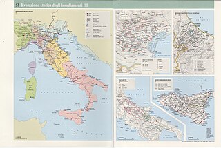
English: The table depicts the historical evolution of settlements in Italy in different ages and referring to different territories. More specifically: A) Settlements in the 18th century. Scale 1: 4 000 000; B)Venetian villas- Scale: 1: 800 000; C)Castles between Marche, Romagna and Montefeltro in the 17th century. Scale: 1: 650 000; D)Sheep trails between Molise and Puglia. Scale: 1: 2 500 000; E) Planned settlements in Sicilia. Scale: 1: 2 000 000. The table is part of the Tematic Atlas realized by the TCI Cartographic Office with CNR - Italian National Research Council (1989-1992) Italiano: La tavola mostra l'evoluzione degli insediamenti in Italia in diverse epoche e facendo riferimento a territori diversi. In dettaglio: A) Insediamenti nel XVIII secolo. Scala 1: 4 000 000; B) Ville veneziane. Scala: 1: 800 000; C) Insediamenti castellari fra Marche, Romagna e Montefeltro nel XVII secolo. Scala: 1: 650 000. D) Tratturi fra Molise e Puglia, Scala: 1: 250 000; E) Nuove fondazioni in Sicilia. Scala: 1 200 000. La tavola fa parte dell'Atlante Tematico realizzato dall'Ufficio Cartografico del TCI con il CNR - Consiglio Nazionale delle Ricerche (1989-1992) |
|
| Date | ||
| Source | Scan from the original work Archivio Storico del Touring Club Italiano | |
| Creator |
TCI Cartographic Office |
|
| Permission (Reusing this file) |
|
|
| Geotemporal data | ||
| Map location | Italy | |
| Map type | Population maps | |
| Scale | 1: 2 000 000;1: 800 000; 1: 650 000; 1: 2 500 000; 1: 2 000 000 | |
| Georeferencing | If inappropriate please set warp_status = skip to hide. | |
| Bibliographic data | ||
| Part of the series | Thematic Atlas of Italy | |
| Language | Italian | |
| Place of publication | Milan | |
| Publisher |
TCI |
|
| Printed by |
TCI |
|
| Archival data | ||
| Collection | ||
| Accession number |
CART.TEM.051 |
|
| Other versions | ||

.jpg)
.jpg)
.jpg)
.jpg)
Licensing
[edit]
File history
Click on a date/time to view the file as it appeared at that time.
| Date/Time | Thumbnail | Dimensions | User | Comment | |
|---|---|---|---|---|---|
| current | 09:52, 27 October 2022 | | 10,829 × 7,272 (47.44 MB) | Ilaria Parma (TCI) (talk | contribs) | pattypan 22.03 |
You cannot overwrite this file.
File usage on Commons
The following 5 pages use this file:
- User:Magog the Ogre/Multilingual legend/2022 October 21-31
- File:Map Historical evolution of settlements III 1992 - Castles between Marche, Romagna and Montefeltro in the 17th century -Touring Club Italiano CART-TEM-051 (cropped).jpg
- File:Map Historical evolution of settlements III 1992 - Settlements in 18th century - Touring Club Italiano CART-TEM-051 (cropped).jpg
- File:Map Historical evolution of settlements III 1992 - Sheep trails between Molise and Puglia and planned settlements in Sicilia - Touring Club Italiano CART-TEM-051 (cropped).jpg
- File:Map Historical evolution of settlements III 1992 - Ville venete - Touring Club Italiano CART-TEM-051 (cropped).jpg