File:Map Europe alliances 1914-sr.svg
Jump to navigation
Jump to search

Size of this PNG preview of this SVG file: 800 × 475 pixels. Other resolutions: 320 × 190 pixels | 640 × 380 pixels | 1,024 × 608 pixels | 1,280 × 761 pixels | 2,560 × 1,521 pixels | 998 × 593 pixels.
Original file (SVG file, nominally 998 × 593 pixels, file size: 90 KB)
Captions
Captions
Add a one-line explanation of what this file represents
| Description |
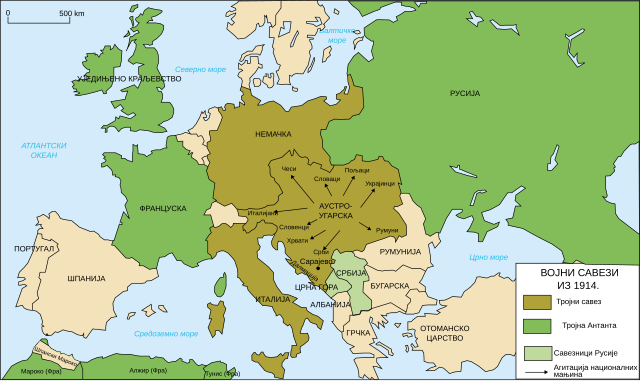
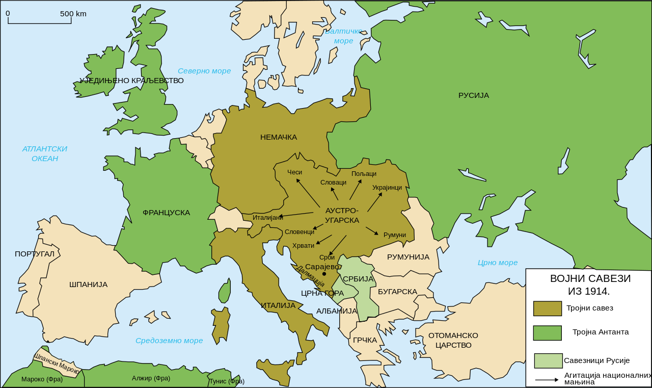
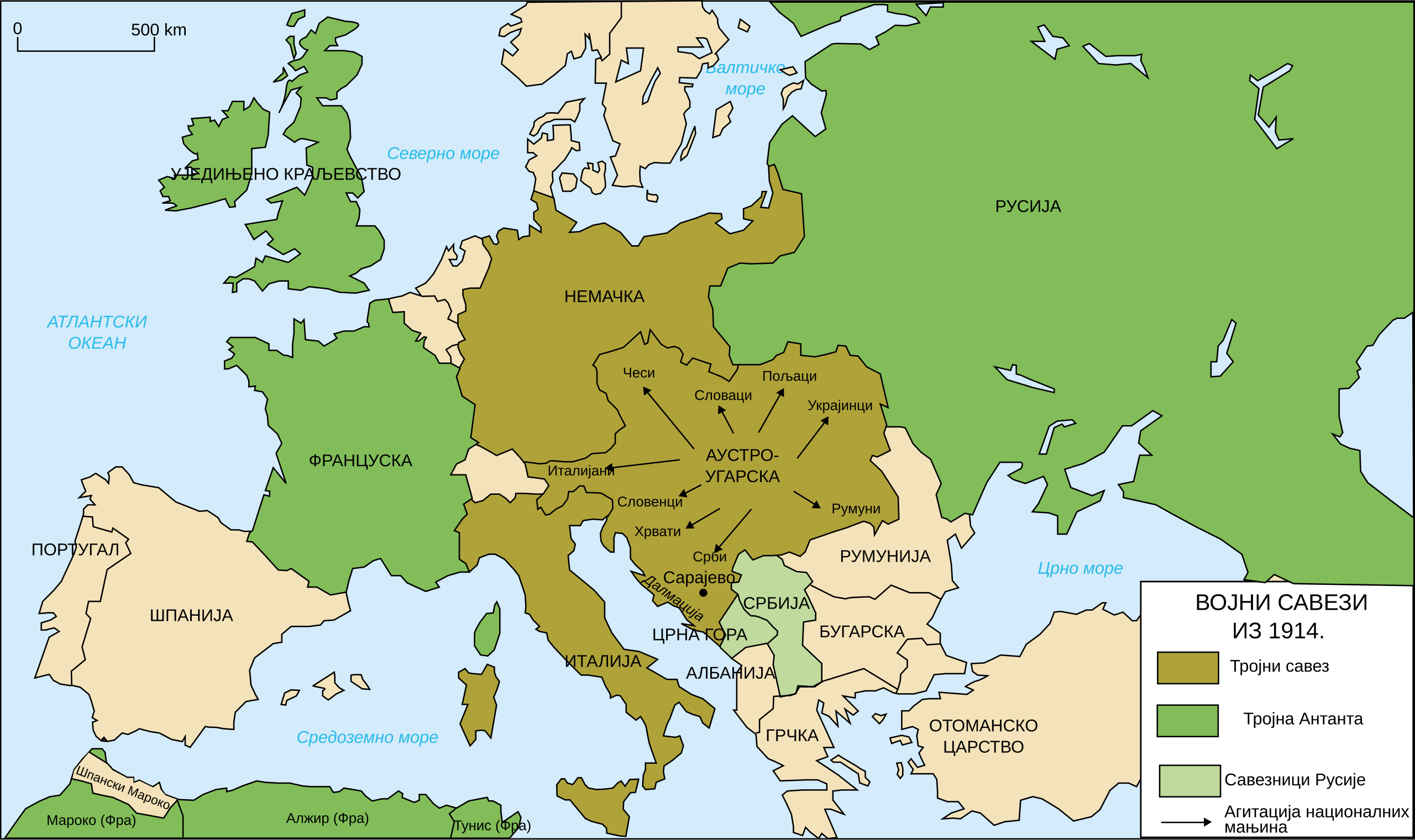
Deutsch: Karte von Militärbündnisse in Europa in 1914, (Serbische)
English: Map of military alliances of Europe in 1914. (Serbian)
Français : Carte des alliances militaires en Europe en 1914. (Serbe)
Русский: Схема военных альянсов в Европе в 1914 г. (серб.)
Српски / srpski: Војни савези у Европи пред Први светски рат (српски/srpski) |
| Date | (UTC) |
| Source | |
| Author |
|
| Other versions |
[]
|
.gif)


|
This SVG file contains embedded text that can be translated into your language, using any capable SVG editor, text editor or the SVG Translate tool. For more information see: About translating SVG files. |
| This is a retouched picture, which means that it has been digitally altered from its original version. Modifications: translated to Serbian. The original can be viewed here: Map Europe alliances 1914-fr.svg:
|
I, the copyright holder of this work, hereby publish it under the following licenses:
This file is licensed under the Creative Commons Attribution-Share Alike 2.5 Generic, 2.0 Generic and 1.0 Generic license.
- You are free:
- to share – to copy, distribute and transmit the work
- to remix – to adapt the work
- Under the following conditions:
- attribution – You must give appropriate credit, provide a link to the license, and indicate if changes were made. You may do so in any reasonable manner, but not in any way that suggests the licensor endorses you or your use.
- share alike – If you remix, transform, or build upon the material, you must distribute your contributions under the same or compatible license as the original.
| This file is licensed under the Creative Commons Attribution-Share Alike 3.0 Unported license. | ||
| ||
| This licensing tag was added to this file as part of the GFDL licensing update. |

|
Permission is granted to copy, distribute and/or modify this document under the terms of the GNU Free Documentation License, Version 1.2 or any later version published by the Free Software Foundation; with no Invariant Sections, no Front-Cover Texts, and no Back-Cover Texts. A copy of the license is included in the section entitled GNU Free Documentation License. |
You may select the license of your choice.
Original upload log
[edit]
This image is a derivative work of the following images:
- File:Map_Europe_alliances_1914-fr.svg licensed with Cc-by-sa-2.5,2.0,1.0, Cc-by-sa-3.0-migrated, GFDL
- 2009-01-13T10:42:22Z Bibi Saint-Pol 998x593 (100739 Bytes) typo
- 2007-02-26T23:36:35Z Bibi Saint-Pol 998x593 (100171 Bytes) {{Information |Description= {{fr|Carte des alliances militaires en Europe en 1914.}} |Source=Création personnelle (version renommée de [[:Image:Les rivalités en Europe en 1914.svg]]) |Date=2006-10-31 |Author=[[User:Histori
Uploaded with derivativeFX
File history
Click on a date/time to view the file as it appeared at that time.
| Date/Time | Thumbnail | Dimensions | User | Comment | |
|---|---|---|---|---|---|
| current | 03:26, 29 July 2009 | | 998 × 593 (90 KB) | BokicaK (talk | contribs) | {{Information |Description={{fr|Carte des alliances militaires en Europe en 1914.}} |Source=*File:Map_Europe_alliances_1914-fr.svg |Date=2009-07-29 03:25 (UTC) |Author=*File:Map_Europe_alliances_1914-fr.svg: historicair *d |
You cannot overwrite this file.
File usage on Commons
The following 37 pages use this file:
- File:1914 ஐரோப்பியக் கூட்டணிகள்.svg
- File:1914년 유럽의 군사동맹지도.PNG
- File:Alliances militaires en Europe 1914-1918-hy.png
- File:Kartenn aliañsoù Europa 1914-br.svg
- File:Map Europe alliances 1914-ar.svg
- File:Map Europe alliances 1914-az.svg
- File:Map Europe alliances 1914-bg.svg
- File:Map Europe alliances 1914-bn.svg
- File:Map Europe alliances 1914-ce.svg
- File:Map Europe alliances 1914-cs.svg
- File:Map Europe alliances 1914-de.svg
- File:Map Europe alliances 1914-el.svg
- File:Map Europe alliances 1914-en.svg
- File:Map Europe alliances 1914-eo.svg
- File:Map Europe alliances 1914-es.svg
- File:Map Europe alliances 1914-fr.svg
- File:Map Europe alliances 1914-gl.svg
- File:Map Europe alliances 1914-he.svg
- File:Map Europe alliances 1914-hr.svg
- File:Map Europe alliances 1914-hu.svg
- File:Map Europe alliances 1914-hy.jpg
- File:Map Europe alliances 1914-it.svg
- File:Map Europe alliances 1914-ko.svg
- File:Map Europe alliances 1914-la.svg
- File:Map Europe alliances 1914-lt.svg
- File:Map Europe alliances 1914-mk.svg
- File:Map Europe alliances 1914-nl.svg
- File:Map Europe alliances 1914-no.svg
- File:Map Europe alliances 1914-ro.svg
- File:Map Europe alliances 1914-sr.svg
- File:Map Europe alliances 1914-sv.svg
- File:Map Europe alliances 1914-ta.png
- File:Map Europe alliances 1914-uk.svg
- File:Map Europe alliances 1914 sr.svg (file redirect)
- File:PotenciasEnLiza1914-pt.svg
- File:PotenciasEnLiza1914.svg
- Template:Other versions/Map Europe alliances 1914
File usage on other wikis
The following other wikis use this file: