File:Map Crusader states 1135-es.svg
Jump to navigation
Jump to search

Size of this PNG preview of this SVG file: 435 × 599 pixels. Other resolutions: 174 × 240 pixels | 348 × 480 pixels | 558 × 768 pixels | 744 × 1,024 pixels | 1,487 × 2,048 pixels | 955 × 1,315 pixels.
Original file (SVG file, nominally 955 × 1,315 pixels, file size: 428 KB)
Captions
Captions
Add a one-line explanation of what this file represents
Summary
[edit]| Description |
[]
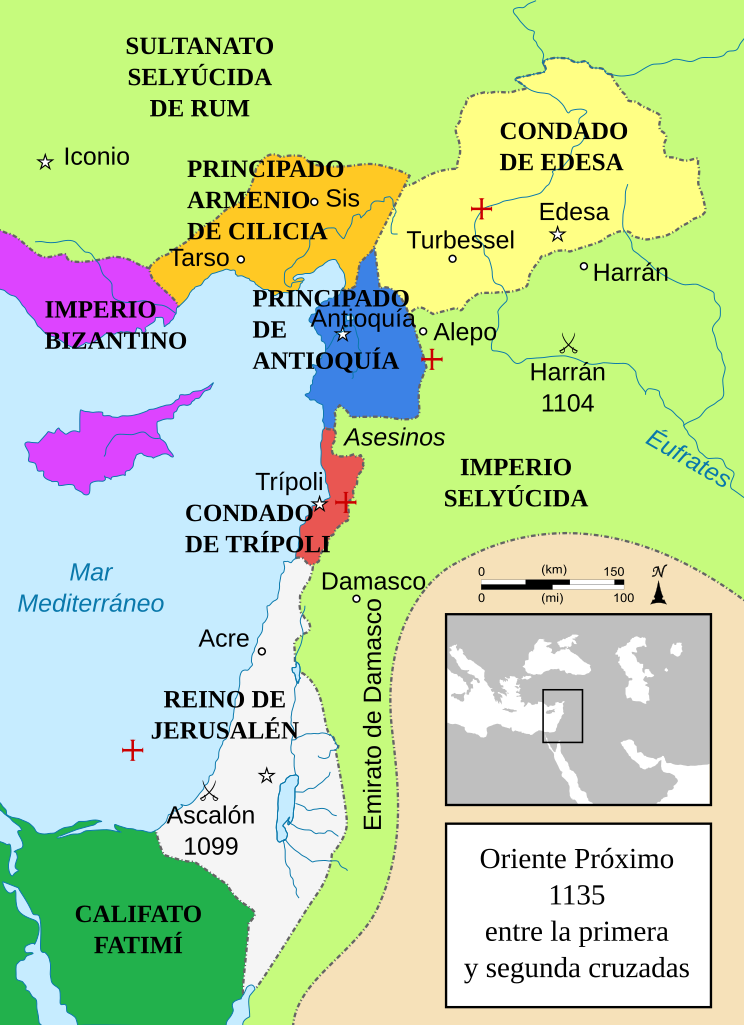
Čeština: Politická mapa Blízkého východu v roce 1135. Deutsch: Die Levante, 1135, zwischen den Ersten und Zweiten Kreuzzügen. Kreuzzugsstaaten sind mit einem roten Kreuz gekennzeichnet Eesti: Lähis-Ida (1135) Español: Oriente Próximo en 1135, entre la primera y segunda cruzadas. Esperanto: Politika mapo de Levantenio dum 1135, inter la krucmilitaroj unuaj kaj duaj. Français : Carte politique du Proche-Orient en 1135, entre la Première et la Seconde Croisades. les États latins d'Orient sont marqués d'une croix rouge. Galego: Mapa dos estados cruzados en Próximo Oriente polo 1135. Italiano: Carta politica del Vicino Oriente nel 1135. Magyar: A Közel-Kelet térképe 1135-ben. Polski: Mapa polityczna Bliskiego Wschodu w roku 1135, w okresie II krucjaty. Ελληνικά: Πολιτικός χάρτης της Μέσης Ανατολής το 1135, ανάμεσα στην πρώτη και τη δεύτερη Σταυροφορία Македонски: Политичка карта на Блискиот Исток во 1135 г. Крстоносните држави се означени со црвени крстови. Русский: Карта Ближнего Востока в 1135 г. Српски / srpski: Politička karta Bliskog Istoka 1135. godine, između Prvog i Drugog krstaškog pohoda. Krstaške države su označene crvenim krstom. ქართული: ახლო აღმოსავლეთი 1135 წელს ไทย: แผนที่ตะวันออกกลาง (คศ. 1135) ระหว่างครูเสดครั้งที่ 1 และครั่งที่ 2 中文: 一副关于1135年近东地区局势的地图,标注红色十字的为十字军国家 العربية : الدويلات الصليبية والدول الإسلامية المجاورة لها في الفترة بين الحملتين الصليبيتين الأولى والثانية. فارسی : نسخه فارسی No description.
|
||||||||||||||
| Date | (UTC) | ||||||||||||||
| Source |
This file was derived from: Near East 1135.svg:  |
||||||||||||||
| Author |
|
||||||||||||||
| Other versions |
[]
See also[edit] |
||||||||||||||


-ka.png)


| This is a retouched picture, which means that it has been digitally altered from its original version. Modifications: translated into Spanish and text turned into real text (editable), some minor text added. The original can be viewed here: Near East 1135.svg:
|
Licensing
[edit]
This file is licensed under the Creative Commons Attribution-Share Alike 3.0 Unported license.
- You are free:
- to share – to copy, distribute and transmit the work
- to remix – to adapt the work
- Under the following conditions:
- attribution – You must give appropriate credit, provide a link to the license, and indicate if changes were made. You may do so in any reasonable manner, but not in any way that suggests the licensor endorses you or your use.
- share alike – If you remix, transform, or build upon the material, you must distribute your contributions under the same or compatible license as the original.
Original upload log
[edit]
This image is a derivative work of the following images:
- File:Near_East_1135.svg licensed with Cc-by-sa-3.0-migrated, GFDL
- 2012-07-25T09:13:10Z HorsefaCe 955x1315 (428529 Bytes) Cilicia wan't a kingdom yet
- 2012-07-25T09:08:37Z HorsefaCe 955x1315 (123164 Bytes) A Chinese version.
- 2010-07-12T11:48:22Z Richardprins 955x1315 (428529 Bytes) Cilicia wan't a kingdom yet
- 2010-07-12T10:59:43Z Richardprins 955x1315 (433931 Bytes) Corrected burid dynasty
- 2010-07-11T22:01:12Z Richardprins 955x1315 (427612 Bytes) Final tweaks
- 2010-07-11T21:52:48Z Richardprins 955x1315 (412162 Bytes) Now complies with w3c so I hope the box is gone
- 2010-07-11T21:22:15Z Richardprins 955x1315 (412660 Bytes) Trying to remove black box
- 2010-07-11T21:18:22Z Richardprins 955x1315 (411612 Bytes) Forgot to convert Med. sea and Euphrates to path
- 2010-07-11T21:15:30Z Richardprins 955x1315 (379595 Bytes) Revision of colors, borders, font, font colors, scale, battle icons, capital icons, city icons, size of crosses. Arrow pointing north added
- 2010-07-10T18:59:48Z Richardprins 955x1315 (515800 Bytes) minor changes and improvements
- 2010-07-10T18:40:26Z Richardprins 955x1315 (515744 Bytes) The coastline was on top of the text and stuff
- 2010-07-10T18:34:32Z Richardprins 955x1315 (515744 Bytes) Changed water color to convention, river color as well. Added blue coastline, changed Byzantine Empire color back
- 2010-07-07T21:30:17Z Richardprins 955x1315 (492798 Bytes) Final colors
- 2010-07-07T21:09:55Z Richardprins 955x1315 (492618 Bytes) Different colors
- 2010-07-07T20:51:08Z Richardprins 955x1315 (492618 Bytes) Changed arabian graytone, revealed some text, changed seljuk empire color
- 2010-07-07T20:45:40Z Richardprins 955x1315 (467821 Bytes) Changed "Caliphate" size, removed black bar, changed seljuq empire color
- 2010-07-07T20:38:56Z Richardprins 955x1315 (468023 Bytes) Wikified text and colors, corrected some names, changed battle icons to official ones, adjusted colors to more logical ones, added red cross next to crusades state names, moved some text around to make city names better visib
- 2008-02-13T04:42:03Z MapMaster 978x1330 (572232 Bytes) Better colors
- 2007-02-01T05:02:58Z MapMaster 978x1330 (572069 Bytes) A number of upgrades
- 2007-02-01T00:23:37Z MapMaster 978x1330 (563572 Bytes) A political map of the [[w:en:Near East]] in 1135 [[w:en:Common Era|CE]].
Uploaded with derivativeFX
File history
Click on a date/time to view the file as it appeared at that time.
| Date/Time | Thumbnail | Dimensions | User | Comment | |
|---|---|---|---|---|---|
| current | 17:48, 31 July 2019 | | 955 × 1,315 (428 KB) | Rowanwindwhistler (talk | contribs) | Fake text added |
| 21:10, 28 March 2013 |  | 955 × 1,315 (184 KB) | Rowanwindwhistler (talk | contribs) | == {{int:filedesc}} == {{Information |Description={{es|1=Oriente Próximo en 1135, entre la primera y segunda cruzadas.}} |Source={{Derived from|Near_East_1135.svg|display=50}} |Date=2013-03-28 21:08 (UTC) |Author=*File:Near_East_1135.svg: '''[[U... |
You cannot overwrite this file.
File usage on Commons
The following 29 pages use this file:
- File:Crusader States (1135)-ka.png
- File:Lähis-Ida 1135.png
- File:Map Crusader states 1135-ar.png
- File:Map Crusader states 1135-cs.svg
- File:Map Crusader states 1135-de.svg
- File:Map Crusader states 1135-de2.svg
- File:Map Crusader states 1135-el.svg
- File:Map Crusader states 1135-en.svg
- File:Map Crusader states 1135-eo.svg
- File:Map Crusader states 1135-es.svg
- File:Map Crusader states 1135-es2.svg
- File:Map Crusader states 1135-fr.svg
- File:Map Crusader states 1135-fr2.svg
- File:Map Crusader states 1135-hu.svg
- File:Map Crusader states 1135-hy.svg
- File:Map Crusader states 1135-it.png
- File:Map Crusader states 1135-jp.png
- File:Map Crusader states 1135-mk.svg
- File:Map Crusader states 1135-nl.svg
- File:Map Crusader states 1135-pl.png
- File:Map Crusader states 1135-pl.svg
- File:Map Crusader states 1135-pt.svg
- File:Map Crusader states 1135-ru.svg
- File:Map Crusader states 1135-zh.svg
- File:Map Crusads states 1135-fa.png
- File:Near East 1135 es.svg (file redirect)
- File:The Crusader States in 1135-ar.svg
- File:The Crusader States in 1135.svg
- Template:Other versions/Map Crusader states 1135
File usage on other wikis
The following other wikis use this file:
- Usage on ast.wikipedia.org
- Usage on es.wikipedia.org
- Usage on gl.wikipedia.org
Metadata
Categories:
- Crusader states
- Maps of Cilicia
- Maps of the County of Edessa
- Maps of the County of Tripoli
- Maps of the Kingdom of Jerusalem
- Maps of the Principality of Antioch
- Maps of the crusades
- Maps of the history of Cyprus
- Maps of the history of the Levant
- Maps of the history of the Middle East
- Spanish-language SVG maps showing history of Asia