File:Map Colmar center.png
Jump to navigation
Jump to search
Size of this preview: 600 × 600 pixels. Other resolutions: 240 × 240 pixels | 480 × 480 pixels | 1,000 × 1,000 pixels.
Original file (1,000 × 1,000 pixels, file size: 1.07 MB, MIME type: image/png)
Captions
Captions
Add a one-line explanation of what this file represents
Summary
[edit]
| Description |
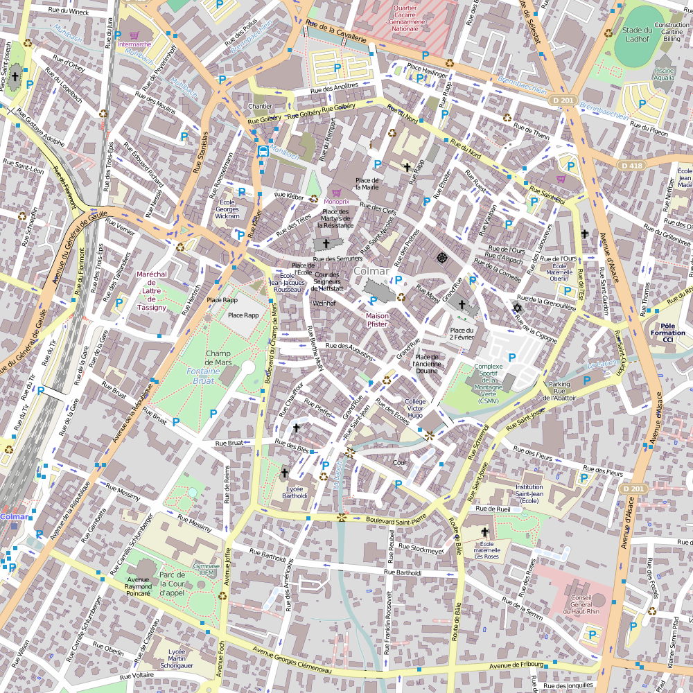
Français : Carte de Colmar centre (Haut-Rhin, France).
English: Map of Colmar center (Haut-Rhin, France). |
| Date | |
| Source | Own work |
| Author | OpenStreetMap contributors |
| Permission (Reusing this file) |
OpenStreetMap data and maps are licensed under the Creative Commons Attribution-ShareAlike 2.0 license (CC-BY-SA 2.0). |
Licensing
[edit]
I, the copyright holder of this work, hereby publish it under the following license:
This file is licensed under the Creative Commons Attribution-Share Alike 3.0 Unported license.
- You are free:
- to share – to copy, distribute and transmit the work
- to remix – to adapt the work
- Under the following conditions:
- attribution – You must give appropriate credit, provide a link to the license, and indicate if changes were made. You may do so in any reasonable manner, but not in any way that suggests the licensor endorses you or your use.
- share alike – If you remix, transform, or build upon the material, you must distribute your contributions under the same or compatible license as the original.
File history
Click on a date/time to view the file as it appeared at that time.
| Date/Time | Thumbnail | Dimensions | User | Comment | |
|---|---|---|---|---|---|
| current | 10:09, 18 May 2014 | | 1,000 × 1,000 (1.07 MB) | Gzen92 (talk | contribs) | {{Information |Description ={{en|1=Map of Colmar center, France}} {{fr|1=Carte de Colmar centre, France}} |Source ={{Own}} |Author =OpenStreetMap contributors |Date =2014-05-18 |Permission =OpenStreetMap data and maps a... |
You cannot overwrite this file.
File usage on Commons
The following page uses this file:
- File:Colmar centre.png (file redirect)
File usage on other wikis
The following other wikis use this file:
- Usage on fr.wikipedia.org
- Stade des Francs
- La Vierge au buisson de roses (Schongauer)
- Maisonnette Bohn
- Maison des Têtes de Colmar
- Maison Pfister
- Maison Kern
- Maison Schongauer
- Maison des chevaliers de Saint-Jean
- Maison Adolph
- Maison Fleischhauer
- Villa Boeschlin
- Maison au 9, rue Turenne à Colmar
- Maison Wildungshof
- Maison zum Kragen
- Maison zum Oesterreich
- Maison Pfeffel
- Maison au 48, rue des Marchands à Colmar
- Maison au 15, rue Berthe-Molly à Colmar
- Maison Sandherr
- Maison des artisans de Colmar
- Commanderie Saint-Jean de Colmar
- Maison aux raisins
- Maison au 8, rue des Augustins à Colmar
- Maison au 4, rue des Boulangers à Colmar
- Maison au 6, rue Morel à Colmar
- Maison au 4, rue Saint-Martin à Colmar
- Zum grienen Hüs (Colmar)
- Pôle Média-Culture Edmond Gerrer
- Stade du Ladhof
- Maison zum roten isen
- Modèle:Géolocalisation/Colmar (centre-ville)
- Avenue Raymond-Poincaré (Colmar)
- Parc Saint François-Xavier
- Parc du Château d'eau
- Rue Saint-Nicolas (Colmar)
- Petite rue des Tanneurs
- Rue des Tourneurs (Colmar)
- Rue Jean-Baptiste-Fleurent
- Rue Mercière (Colmar)
- Square Hirn
- Square Pfeffel
- Parc Méquillet
- Square de la Montagne-Verte
- Rue Wickram
- Impasse de la Maison-Rouge (Colmar)
- Impasse Hertenbrod
- Rue de l'Ancienne-Poste
- Rue de la Porte-Neuve
- Rue Weinemer
- Rue de la Herse
View more global usage of this file.