File:Map Chhattisgarh state and districts.png
Jump to navigation
Jump to search

Size of this preview: 403 × 600 pixels. Other resolutions: 161 × 240 pixels | 451 × 671 pixels.
Original file (451 × 671 pixels, file size: 32 KB, MIME type: image/png)
Captions
Captions
Abujmarh, Chhattisgarh. The biosphere reserve.
Loriya change to name of koriya not a loriya
Summary
[edit]
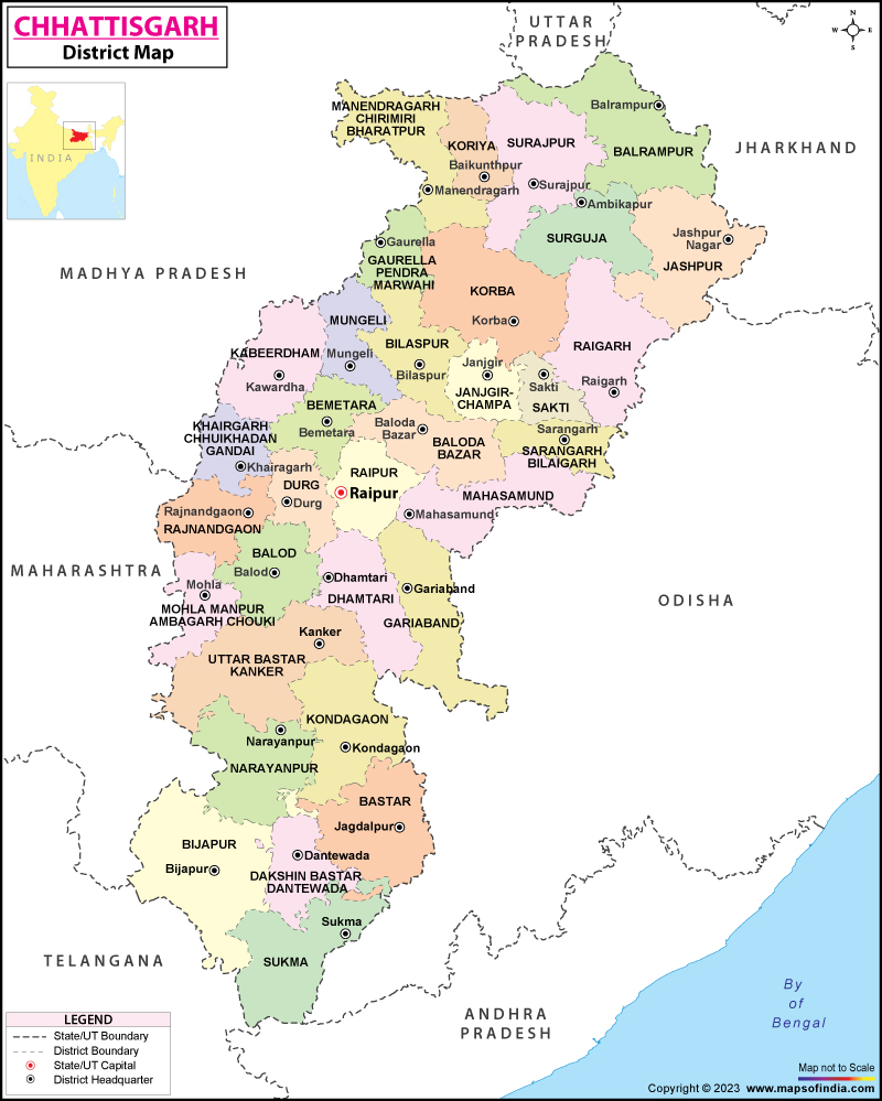
| Description |
Chhattisgarh State (India) with district boundries and city marks - Self Made - w:User:Miljoshi - Jan 2006 Note: co-ordinates are estimated, and may not be exactly accurate. |
| Date | 1 January 2006 (original upload date) |
| Source | No machine-readable source provided. Own work assumed (based on copyright claims). |
| Author | No machine-readable author provided. Miljoshi assumed (based on copyright claims). |
Licensing
[edit]
I, the copyright holder of this work, hereby publish it under the following licenses:

|
Permission is granted to copy, distribute and/or modify this document under the terms of the GNU Free Documentation License, Version 1.2 or any later version published by the Free Software Foundation; with no Invariant Sections, no Front-Cover Texts, and no Back-Cover Texts. A copy of the license is included in the section entitled GNU Free Documentation License. |
| This file is licensed under the Creative Commons Attribution-Share Alike 3.0 Unported license. | ||
| ||
| This licensing tag was added to this file as part of the GFDL licensing update. |
This file is licensed under the Creative Commons Attribution-Share Alike 2.5 Generic, 2.0 Generic and 1.0 Generic license.
- You are free:
- to share – to copy, distribute and transmit the work
- to remix – to adapt the work
- Under the following conditions:
- attribution – You must give appropriate credit, provide a link to the license, and indicate if changes were made. You may do so in any reasonable manner, but not in any way that suggests the licensor endorses you or your use.
- share alike – If you remix, transform, or build upon the material, you must distribute your contributions under the same or compatible license as the original.
You may select the license of your choice.
http://www.mapsofindia.com/maps/chhattisgarh/chhattisgarh.jpg
File history
Click on a date/time to view the file as it appeared at that time.
| Date/Time | Thumbnail | Dimensions | User | Comment | |
|---|---|---|---|---|---|
| current | 17:01, 2 January 2006 | | 451 × 671 (32 KB) | Miljoshi (talk | contribs) | Update - added tag for Uttar Pradesh |
| 14:06, 1 January 2006 |  | 451 × 671 (32 KB) | Miljoshi (talk | contribs) | Chhattisgarh State (India) with district boundries and city marks - Self Made - w:User:Miljoshi - Jan 2006 Note: co-ordinates are estimated, and may not be exactly accurate. Category:Chhattisgarh district maps |
You cannot overwrite this file.
File usage on Commons
The following 4 pages use this file:
File usage on other wikis
The following other wikis use this file:
- Usage on ar.wikipedia.org
- Usage on arz.wikipedia.org
- Usage on as.wikipedia.org
- Usage on bn.wikipedia.org
- Usage on ca.wikipedia.org
- Usage on de.wikipedia.org
- Usage on de.wikivoyage.org
- Usage on en.wikipedia.org
- Usage on en.wikivoyage.org
- Usage on es.wikipedia.org
- Usage on eu.wikipedia.org
- Usage on fi.wikipedia.org
- Usage on fr.wikipedia.org
- Usage on gu.wikipedia.org
- Usage on hi.wikipedia.org
- Usage on id.wikipedia.org
- Usage on it.wikipedia.org
- Chhattisgarh
- Distretto di Bastar
- Distretto di Bilaspur (Chhattisgarh)
- Distretto di Dantewada
- Distretto di Dhamtari
- Distretto di Durg
- Distretto di Janjgir-Champa
- Distretto di Jashpur
- Distretto di Kanker
- Distretto di Kawardha
- Distretto di Korba
- Distretto di Korea
- Distretto di Mahasamund
- Distretto di Raigarh
View more global usage of this file.