File:Map Catalog.jpg
Jump to navigation
Jump to search
No higher resolution available.
Map_Catalog.jpg (416 × 312 pixels, file size: 20 KB, MIME type: image/jpeg)
Captions
Captions
Add a one-line explanation of what this file represents
Summary
[edit]
| Description |
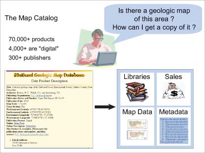
English: Figure 5. Interested in knowing something about the geology of an area (such as the land beneath their house), the user queries the Geoscience Map Catalog, which returns a hit list of possibly useful maps and related products. The user selects one of these and, from the Product Description Page (shown on left side of figure), obtains further information and can then choose to buy the product, view and download it, inspect the metadata, or find it at a depository library. |
| Date | |
| Source | The National Geologic Map Database Project: Overview and Progress |
| Author | David R. Soller, Thomas M. Berg, and Nancy R. Stamm |
Licensing
[edit]
This work is in the public domain in the United States because it is a work prepared by an officer or employee of the United States Government as part of that person’s official duties under the terms of Title 17, Chapter 1, Section 105 of the US Code.
Note: This only applies to original works of the Federal Government and not to the work of any individual U.S. state, territory, commonwealth, county, municipality, or any other subdivision. This template also does not apply to postage stamp designs published by the United States Postal Service since 1978. (See § 313.6(C)(1) of Compendium of U.S. Copyright Office Practices). It also does not apply to certain US coins; see The US Mint Terms of Use.
|
 | |
| This file has been identified as being free of known restrictions under copyright law, including all related and neighboring rights. | ||
File history
Click on a date/time to view the file as it appeared at that time.
| Date/Time | Thumbnail | Dimensions | User | Comment | |
|---|---|---|---|---|---|
| current | 23:52, 24 November 2008 | | 416 × 312 (20 KB) | Mdd (talk | contribs) | == Summary == {{Information |Description={{en|1= Figure 5. Interested in knowing something about the geology of an area (such as the land beneath their house), the user queries the Geoscience Map Catalog, which returns a hit list of possibly useful maps a |
You cannot overwrite this file.
File usage on Commons
There are no pages that use this file.