File:Map Burgundian Netherlands 1477-hu.png
Original file (555 × 637 pixels, file size: 170 KB, MIME type: image/png)
Captions
Captions
Summary
[edit]
| Description |
Magyar: Az svg png változatban, mert egyébként rossz. |
| Date | |
| Source | File:Map Burgundian Netherlands 1477-fr.svg |
| Author |
|
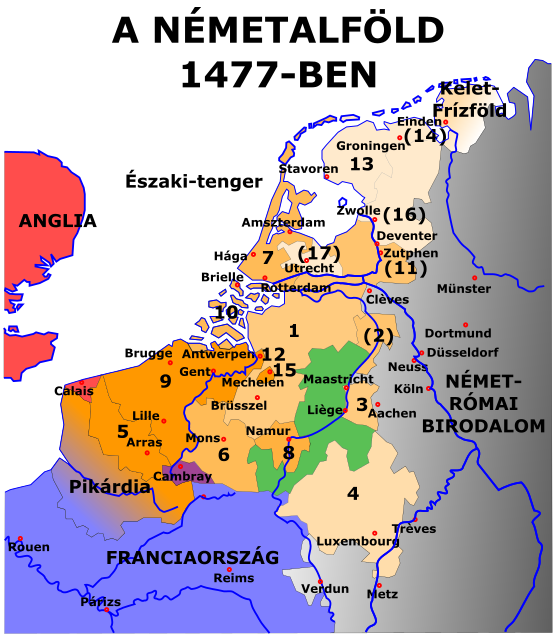
Jelmagyarázat
[edit]
Narancssárga: A burgundiai hercegek és V. Károly uralma alatt lévő területek
- 1384 : Artois (5), Flandria (9), Mechelen (15)
- 1427 : Namur (8)
- 1428 : Hainaut (6), Zeeland (10), Holland (7)
- 1430 : Brabant (1), Limburg (3)
- 1443 : Luxemburg (4)
- V. Károly uralma alatt
- Utrecht (17), Nyugat- és Kelet-Frízföld (13), Gueldre (2)
- Elvesztett és visszaszerzett tartományok: Groningen (14), Overijssel (16), Zutphen (11)
- Pikárdiát 1477-ben elfoglalta Franciaország
Zöld: A független Liège-i Püspökség
Piros: Anglia
Kék: Franciaország
Szürke: Német-római Birodalom
A tizenhét tartomány
[edit]
1. Brabanti Hercegség
2. Guelders Hercegség
3. Limburgi Hercegség
4. Luxemburgi Nagyhercegség
5. Atois-i Grófság
6. Hainaut-i Grófság
7. Holland Grófság
8. Namuri Grófság
9. Flamand Grófság
10. Zeelandi Grófság
11. Zuthpheni Grófság
12. Antwerpeni Őrgrófság
13. Friesland uradalom
14. Groningen uradalom
15. Mechelen uradalom
16. Overijssel uradalom
17. Utrechti uradalom
Licensing
[edit]

|
Permission is granted to copy, distribute and/or modify this document under the terms of the GNU Free Documentation License, Version 1.2 or any later version published by the Free Software Foundation; with no Invariant Sections, no Front-Cover Texts, and no Back-Cover Texts. A copy of the license is included in the section entitled GNU Free Documentation License. |
- You are free:
- to share – to copy, distribute and transmit the work
- to remix – to adapt the work
- Under the following conditions:
- attribution – You must give appropriate credit, provide a link to the license, and indicate if changes were made. You may do so in any reasonable manner, but not in any way that suggests the licensor endorses you or your use.
- share alike – If you remix, transform, or build upon the material, you must distribute your contributions under the same or compatible license as the original.
File history
Click on a date/time to view the file as it appeared at that time.
| Date/Time | Thumbnail | Dimensions | User | Comment | |
|---|---|---|---|---|---|
| current | 00:20, 19 March 2016 | | 555 × 637 (170 KB) | Bencoke (talk | contribs) | levágás felül |
| 21:14, 18 March 2016 |  | 554 × 783 (171 KB) | Bencoke (talk | contribs) | {{Information |Description ={{hu|1=Az svg png változatban, mert egyébként rossz.}} |Source =File:Map Burgundian Netherlands 1477-fr.svg |Author =*File:Map Burgundian Netherlands 1477-fr.svg: Denis Jacquerye *derivative w... |
You cannot overwrite this file.
File usage on Commons
There are no pages that use this file.
File usage on other wikis
The following other wikis use this file:
- Usage on hu.wikipedia.org