File:Map Bih entities cyr.png
Jump to navigation
Jump to search

Size of this preview: 633 × 599 pixels. Other resolutions: 254 × 240 pixels | 507 × 480 pixels | 811 × 768 pixels | 1,103 × 1,044 pixels.
Original file (1,103 × 1,044 pixels, file size: 67 KB, MIME type: image/png)
Captions
Captions
Add a one-line explanation of what this file represents
Summary
[edit]| Description |
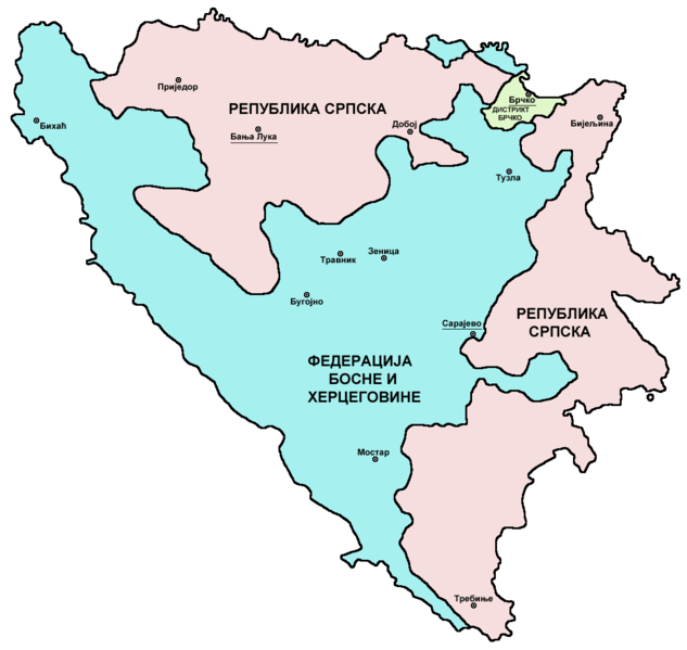
English: Map showing political division of Bosnia and Herzegovina: Federation of Bosnia and Herzegovina, Republika Srpska and Brčko District. Српски / srpski: Мапа која приказује политичку поделу Босне и Херцеговине: Федерацију Босне и Херцеговине, Републику Српску и Дистрикт Брчко. |
| Date | |
| Source | Own work |
| Author | PANONIAN |
| Other versions |
[]
|


.png)


Licensing
[edit]
I, the copyright holder of this work, hereby publish it under the following license:
| This file is made available under the Creative Commons CC0 1.0 Universal Public Domain Dedication. | |
| The person who associated a work with this deed has dedicated the work to the public domain by waiving all of their rights to the work worldwide under copyright law, including all related and neighboring rights, to the extent allowed by law. You can copy, modify, distribute and perform the work, even for commercial purposes, all without asking permission.
|
References
[edit]
- Slobodan Radovanović, Geografski atlas, Magic Map, Smederevska Palanka, 2001.
- Geografski atlas, Intersistem kartografija, Beograd, 2004.
- http://www.ohr.int/ohr-offices/brcko/images/map-brcko-district.jpg
- http://world-gazetteer.com/ archive copy at the Wayback Machine
File history
Click on a date/time to view the file as it appeared at that time.
| Date/Time | Thumbnail | Dimensions | User | Comment | |
|---|---|---|---|---|---|
| current | 15:38, 12 September 2012 | | 1,103 × 1,044 (67 KB) | WikiEditor2004 (talk | contribs) | {{Information |Description ={{en|1=Map showing political division of Bosnia and Herzegovina: Federation of Bosnia and Herzegovina, Republika Srpska and Brčko District.}} |Source ={{own}} |Author =PANONIAN |Date ... |
You cannot overwrite this file.
File usage on Commons
The following 8 pages use this file:
File usage on other wikis
The following other wikis use this file:
- Usage on sr.wikipedia.org