File:Map Anglican Communion.svg
Jump to navigation
Jump to search

Size of this PNG preview of this SVG file: 800 × 353 pixels. Other resolutions: 320 × 141 pixels | 640 × 283 pixels | 1,024 × 452 pixels | 1,280 × 565 pixels | 2,560 × 1,130 pixels | 940 × 415 pixels.
Original file (SVG file, nominally 940 × 415 pixels, file size: 3.09 MB)
Captions
Captions
Add a one-line explanation of what this file represents
Summary
[edit]| Description |
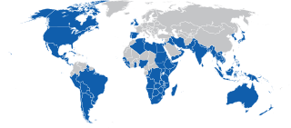
Deutsch: Karte der Staaten mit Provinzen der Anglikanischen Gemeinschaft
English: Map of countries with provinces of the Anglican Communion
Italiano: Mappa dei paesi con province della Comunione Anglicana
|
||
| Date | |||
| Source |
|
||
| Author | NordNordWest | ||
| Permission (Reusing this file) |
|

File history
Click on a date/time to view the file as it appeared at that time.
| Date/Time | Thumbnail | Dimensions | User | Comment | |
|---|---|---|---|---|---|
| current | 21:37, 20 August 2020 | | 940 × 415 (3.09 MB) | Hogweard (talk | contribs) | South Sudan |
| 20:07, 23 March 2010 |  | 940 × 415 (2.68 MB) | NordNordWest (talk | contribs) | == {{int:filedesc}} == {{Information {{de|Karte der Staaten mit Provinzen der Anglikanischen Gemeinschaft}} {{en|Map of countries with provinces of the Anglican Communion}} {{Kartenwerkstatt}} |
You cannot overwrite this file.
File usage on Commons
The following page uses this file:
File usage on other wikis
The following other wikis use this file:
- Usage on de.wikipedia.org
- Usage on kbp.wikipedia.org
- Usage on la.wikipedia.org
- Usage on sk.wikipedia.org