File:Map Anatolia ancient regions-en.svg

Original file (SVG file, nominally 921 × 596 pixels, file size: 256 KB)
Captions
Captions
| Description |
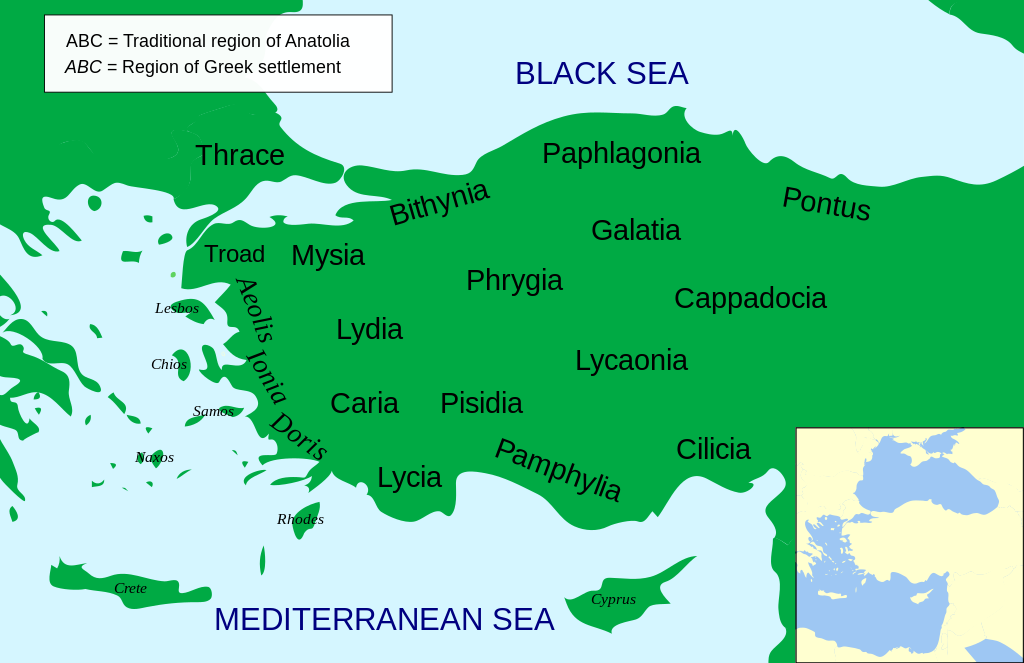
Català: Mapa regional d'Àsia Menor al segle II aC
English: Regional map of Asia Minor in the 2nd Century BC |
| Date | (UTC) |
| Source | |
| Author |
|
| Other versions |
Other related versions: []
Derivative works of this file: |


.svg)


|
This SVG file contains embedded text that can be translated into your language, using any capable SVG editor, text editor or the SVG Translate tool. For more information see: About translating SVG files. |
This file is translated using SVG <switch> elements. All translations are stored in the same file! Learn more.
For most Wikipedia projects, you can embed the file normally (without a To translate the text into your language, you can use the SVG Translate tool. Alternatively, you can download the file to your computer, add your translations using whatever software you're familiar with, and re-upload it with the same name. You will find help in Graphics Lab if you're not sure how to do this. |
| This is a retouched picture, which means that it has been digitally altered from its original version. Modifications: Increased legibility, slight corrections in position. The original can be viewed here: Asia Minor Political 500BC.svg:
|
- You are free:
- to share – to copy, distribute and transmit the work
- to remix – to adapt the work
- Under the following conditions:
- attribution – You must give appropriate credit, provide a link to the license, and indicate if changes were made. You may do so in any reasonable manner, but not in any way that suggests the licensor endorses you or your use.
- share alike – If you remix, transform, or build upon the material, you must distribute your contributions under the same or compatible license as the original.

|
Permission is granted to copy, distribute and/or modify this document under the terms of the GNU Free Documentation License, Version 1.2 or any later version published by the Free Software Foundation; with no Invariant Sections, no Front-Cover Texts, and no Back-Cover Texts. A copy of the license is included in the section entitled GNU Free Documentation License. |
Original upload log
[edit]
This image is a derivative work of the following images:
- File:Asia_Minor_Political_500BC.svg licensed with Cc-by-sa-3.0, GFDL
- 2009-04-22T07:38:42Z MinisterForBadTimes 921x596 (283615 Bytes) Coloured in rogue region
- 2009-04-22T07:36:20Z MinisterForBadTimes 921x596 (283353 Bytes) Changed fonts...again
- 2009-04-22T07:33:39Z MinisterForBadTimes 921x596 (283414 Bytes) Changed fonts
- 2009-04-22T07:25:50Z MinisterForBadTimes 921x596 (284262 Bytes) {{Information |Description={{en|1= Political map of Asia Minor in 500 BC}} |Source=*[[:File:Mysia.svg|]] |Date=2009-04-22 08:23 (UTC) |Author=*[[:File:Mysia.svg|]]: [[User:Emok|Emok]] *derivative work: *[[:Image:Mysia_map_anc
Uploaded with derivativeFX
File history
Click on a date/time to view the file as it appeared at that time.
| Date/Time | Thumbnail | Dimensions | User | Comment | |
|---|---|---|---|---|---|
| current | 14:14, 15 February 2024 | | 921 × 596 (256 KB) | Manlleus (talk | contribs) | File uploaded using svgtranslate tool (https://svgtranslate.toolforge.org/). Added translation for ca. |
| 14:01, 15 February 2024 |  | 921 × 596 (235 KB) | Manlleus (talk | contribs) | fixed text labels for translation | |
| 19:48, 23 April 2009 |  | 921 × 596 (278 KB) | MinisterForBadTimes (talk | contribs) | Added Galatia, minor other changes | |
| 16:01, 22 April 2009 |  | 921 × 596 (277 KB) | MinisterForBadTimes (talk | contribs) | {{Information |Description={{en|1= Political map of Asia Minor in 500 BC}} |Source=*File:Asia_Minor_Political_500BC.svg |Date=2009-04-22 17:00 (UTC) |Author=*File:Asia_Minor_Political_500BC.svg: *Mysia.svg: [[User:Emok|Emok |
You cannot overwrite this file.
File usage on Commons
The following 28 pages use this file:
- User:Magog the Ogre/Multilingual legend/2024 February 15-19
- File:AnatoliaAncientRegions.png
- File:Anatolia Ancient Regions ID.png
- File:Anatolia Ancient Regions base.svg (file redirect)
- File:Lycia locator map.svg
- File:Map Anatolia ancient regions-af.jpg
- File:Map Anatolia ancient regions-el.svg
- File:Map Anatolia ancient regions-en.svg
- File:Map Anatolia ancient regions-es.svg
- File:Map Anatolia ancient regions-grc.svg
- File:Map Anatolia ancient regions-hu.svg
- File:Map Anatolia ancient regions-it.svg
- File:Map Anatolia ancient regions-mk.svg
- File:Map Anatolia ancient regions-pt.svg
- File:Map Anatolia ancient regions-ru.png
- File:Map Anatolia ancient regions-ru.svg
- File:Map Anatolia ancient regions-sl.svg
- File:Map Anatolia ancient regions-tr.svg
- File:Map Anatolia ancient regions-uk.svg
- File:Map Anatolia ancient regions-zh.svg
- File:Map Anatolia ancient regions (Indonesian version).svg
- File:Political map of Asia Minor in 500 BC in Masry.PNG
- File:مناطق آناتولی باستان.svg
- Template:Other versions/Map Anatolia ancient regions
- Category:Ionian Revolt
File usage on other wikis
The following other wikis use this file:
- Usage on af.wikipedia.org
- Usage on als.wikipedia.org
- Usage on am.wikipedia.org
- Usage on ar.wikipedia.org
- Usage on azb.wikipedia.org
- Usage on az.wikipedia.org
- Usage on be-tarask.wikipedia.org
- Usage on bg.wikipedia.org
- Usage on bn.wikipedia.org
- Usage on br.wikipedia.org
- Usage on bs.wikipedia.org
- Usage on ca.wikipedia.org
- Usage on cs.wikipedia.org
- Usage on da.wikipedia.org
- Usage on de.wikipedia.org
- Usage on diq.wikipedia.org
- Usage on en.wikipedia.org
View more global usage of this file.