File:Map (AM 1997.15.26.8-2).jpg
Jump to navigation
Jump to search
Size of this preview: 800 × 555 pixels. Other resolutions: 320 × 222 pixels | 640 × 444 pixels | 1,024 × 711 pixels | 1,280 × 889 pixels | 2,560 × 1,777 pixels | 4,936 × 3,427 pixels.
Original file (4,936 × 3,427 pixels, file size: 9.67 MB, MIME type: image/jpeg)
Captions
Captions
Add a one-line explanation of what this file represents
Summary
[edit]| Map
( |
||||||||||||||||||||||||
|---|---|---|---|---|---|---|---|---|---|---|---|---|---|---|---|---|---|---|---|---|---|---|---|---|
| Artist |
not researched |
|||||||||||||||||||||||
| Title |
Map |
|||||||||||||||||||||||
| Object type | Occupying forces/wars Classification: NM3.12588 |
|||||||||||||||||||||||
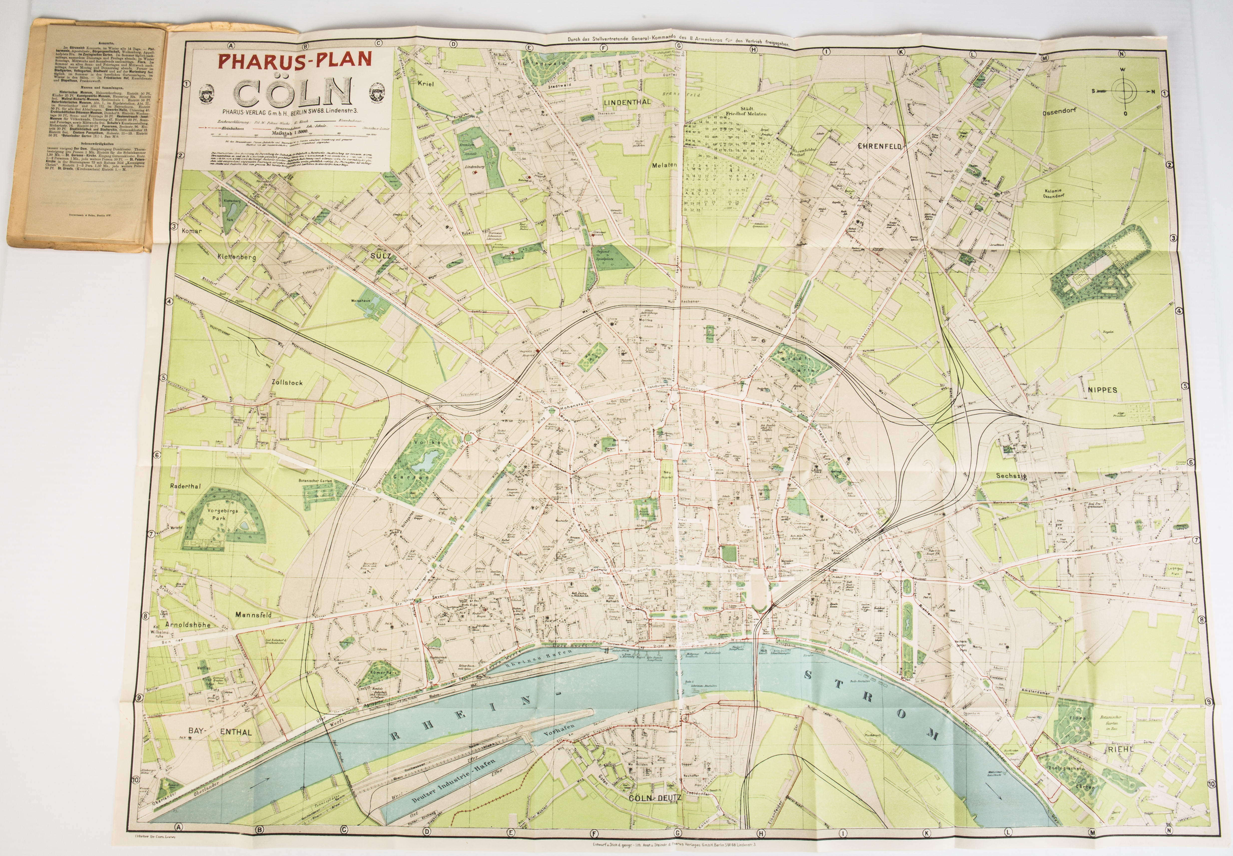
| Description |
English: Map- Pharus Plan, Coln (Cologne), that belonged to 61957 2-Lt Daniel Patrick Reardon, NZ Field Artillery, WW1 |
|||||||||||||||||||||||
| Date | World War 1, 1914-18-wars; Circa 1918; 1997; 04 Mar 1997 | |||||||||||||||||||||||
| Dimensions |
height: 120mm |
|||||||||||||||||||||||
| Collection |
|
|||||||||||||||||||||||
| Accession number |
1997.15.26.8 |
|||||||||||||||||||||||
| Place of creation | Europe; Cologne; Berlin; Germany | |||||||||||||||||||||||
| Credit line | Collection of Auckland Museum Tamaki Paenga Hira, 1997.15.26.8 | |||||||||||||||||||||||
| Source/Photographer | Photo | |||||||||||||||||||||||
| Permission (Reusing this file) |
This image has been released as "CCBY" by Auckland Museum. For details refer to the Commons project page. | |||||||||||||||||||||||
| Other versions |
|
|||||||||||||||||||||||

.jpg)
.jpg)
.jpg)
.jpg)
.jpg)
.jpg&action=edit§ion=1)
Licensing
[edit].jpg&action=edit§ion=2)
This file is licensed under the Creative Commons Attribution 4.0 International license.
Attribution: Auckland Museum
- You are free:
- to share – to copy, distribute and transmit the work
- to remix – to adapt the work
- Under the following conditions:
- attribution – You must give appropriate credit, provide a link to the license, and indicate if changes were made. You may do so in any reasonable manner, but not in any way that suggests the licensor endorses you or your use.
File history
Click on a date/time to view the file as it appeared at that time.
| Date/Time | Thumbnail | Dimensions | User | Comment | |
|---|---|---|---|---|---|
| current | 06:51, 17 November 2019 | | 4,936 × 3,427 (9.67 MB) | Fæ (talk | contribs) | Auckland Museum Page 700.48 Object #70047 1997.15.26.8 Image 2/6 http://api.aucklandmuseum.com/id/media/v/358272 |
You cannot overwrite this file.
File usage on Commons
The following 6 pages use this file:
.jpg)
.jpg&oldid=829709269)