File:Map-Southern Africa-ru.png
Jump to navigation
Jump to search

Size of this preview: 800 × 501 pixels. Other resolutions: 320 × 201 pixels | 640 × 401 pixels | 1,024 × 642 pixels | 1,313 × 823 pixels.
Original file (1,313 × 823 pixels, file size: 148 KB, MIME type: image/png)
Captions
Captions
Add a one-line explanation of what this file represents
Summary
[edit]
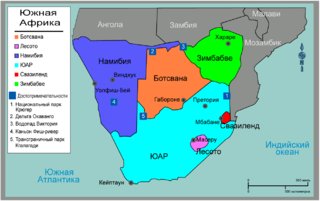
| Description | Map of Southern Africa regions for use on Wikivoyage, Russian version |
| Date | 27 May 2007 (original upload date) |
| Source | Own work based on the map of Africa |
| Author | Nick Roux and Shaund, Russian translation by Digr |
| Other versions | SVG base file |
Licensing
[edit]
| This work has been released into the public domain by its author, User: (WT-shared) Digr at wts wikivoyage. This applies worldwide. In some countries this may not be legally possible; if so: User: (WT-shared) Digr at wts wikivoyage grants anyone the right to use this work for any purpose, without any conditions, unless such conditions are required by law.
|
Original upload log
[edit]
| This file was imported from Wikivoyage WTS. |
The original description page was here. All following user names refer to wts.wikivoyage-old.
- 2008-11-21 10:28 (WT-shared) Digr[dead link] 1313×823 (151643 bytes) == Summary == {{Imagecredit|credit=Digr, based on work by Nick Roux |captureDate=21 November 2008|location=Southern Africa|source=[[Image:Ma (Import from wikitravel.org/shared)
File history
Click on a date/time to view the file as it appeared at that time.
| Date/Time | Thumbnail | Dimensions | User | Comment | |
|---|---|---|---|---|---|
| current | 21:22, 17 November 2012 | | 1,313 × 823 (148 KB) | MGA73bot2 (talk | contribs) | {{BotMoveToCommons|wts.oldwikivoyage|year={{subst:CURRENTYEAR}}|month={{subst:CURRENTMONTHNAME}}|day={{subst:CURRENTDAY}}}} == {{int:filedesc}} == {{Information |description=Map of Southern Africa Regions. Wikivoyage Regions by color, Countries of Sout... |
You cannot overwrite this file.
File usage on Commons
There are no pages that use this file.