File:Manchester Victoria 2 geograph-2463854-by-Ben-Brooksbank.jpg
Jump to navigation
Jump to search

Size of this preview: 800 × 439 pixels. Other resolutions: 320 × 176 pixels | 640 × 352 pixels | 1,024 × 562 pixels | 1,280 × 703 pixels | 2,394 × 1,315 pixels.
Original file (2,394 × 1,315 pixels, file size: 518 KB, MIME type: image/jpeg)
Captions
Captions
Add a one-line explanation of what this file represents
Summary
[edit]
| Description |
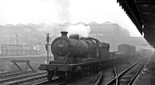
English: LNER 2-8-0 on westbound freight in the LMS stronghold, Manchester Victoria. View eastward, from the Platforms 3/11 joining Exchange with Victoria Stations in Manchester. The main through platforms of Victoria are on the left in the wintry gloom. There was a constant flow of freight traffic across Manchester by this route. This ex-GC Class O4/3 2-8-0 No. 63686 was from Northwich (Cheshire Lines), probably working to Trafford Park Yard. These 521 O4/3 2-8-0's were from Robinson's very successful Great Central Class 8A of 1911 (LNER Class O4), which were ordered in February 1917 by the War Office (Railway Operating Department) for operation behind the Western Front with the British Army: in the event only 52 many were in fact sent over to France and none was lost. Most were built after the War had ended in November 1918. After World War One these 'ROD's' were stored in dumps for many years before eventually being sold to the main line Railways. In World War Two, 92 O4's were requisitioned again and sent to the Middle East, never to return. |
| Date | |
| Source | From geograph.org.uk |
| Author | Ben Brooksbank |
| Permission (Reusing this file) |
Creative Commons Attribution Share-alike license 2.0 |
| Attribution (required by the license) | Ben Brooksbank / LNER 2-8-0 on westbound freight in the LMS stronghold, Manchester Victoria / |
| Camera location | | View this and other nearby images on: OpenStreetMap |
|---|
Licensing
[edit]

|
This image was taken from the Geograph project collection. See this photograph's page on the Geograph website for the photographer's contact details. The copyright on this image is owned by Ben Brooksbank and is licensed for reuse under the Creative Commons Attribution-ShareAlike 2.0 license.
|
This file is licensed under the Creative Commons Attribution-Share Alike 2.0 Generic license.
Attribution: Ben Brooksbank
- You are free:
- to share – to copy, distribute and transmit the work
- to remix – to adapt the work
- Under the following conditions:
- attribution – You must give appropriate credit, provide a link to the license, and indicate if changes were made. You may do so in any reasonable manner, but not in any way that suggests the licensor endorses you or your use.
- share alike – If you remix, transform, or build upon the material, you must distribute your contributions under the same or compatible license as the original.
File history
Click on a date/time to view the file as it appeared at that time.
| Date/Time | Thumbnail | Dimensions | User | Comment | |
|---|---|---|---|---|---|
| current | 16:15, 19 June 2011 | | 2,394 × 1,315 (518 KB) | Chevin (talk | contribs) | == {{int:filedesc}} == {{Information |Description={{en|1=LNER 2-8-0 on westbound freight in the LMS stronghold, Manchester Victoria View eastward, from the Platforms 3/11 joining Exchange with Victoria Stations in Manchester. The main through platforms of |
You cannot overwrite this file.
File usage on Commons
There are no pages that use this file.
File usage on other wikis
The following other wikis use this file:
- Usage on en.wikipedia.org