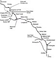
File:Manchester, Buxton, Matlock and Midland Railway and connections (diagram).jpg
From Wikimedia Commons, the free media repository
Jump to navigation
Jump to search

Size of this preview: 576 × 600 pixels. Other resolutions: 230 × 240 pixels | 461 × 480 pixels | 700 × 729 pixels.
Original file (700 × 729 pixels, file size: 48 KB, MIME type: image/jpeg)
File information
Structured data
Captions
Captions
Add a one-line explanation of what this file represents
Summary
[edit]| DescriptionManchester, Buxton, Matlock and Midland Railway and connections (diagram).jpg |
English: Sketch map of the Manchester, Buxton, Matlock and Midlands Junction Railway from Ambergate to Chinley. |
| Date | |
| Source | Own work |
| Author | chevin |
| Permission (Reusing this file) |
free use |

|
This map image could be re-created using vector graphics as an SVG file. This has several advantages; see Commons:Media for cleanup for more information. If an SVG form of this image is available, please upload it and afterwards replace this template with
{{vector version available|new image name}}.
It is recommended to name the SVG file “Manchester, Buxton, Matlock and Midland Railway and connections (diagram).svg”—then the template Vector version available (or Vva) does not need the new image name parameter. |
 | This map image was uploaded in the JPEG format even though it consists of non-photographic data. This information could be stored more efficiently or accurately in the PNG or SVG format. If possible, please upload a PNG or SVG version of this image without compression artifacts, derived from a non-JPEG source (or with existing artifacts removed). After doing so, please tag the JPEG version with {{Superseded|NewImage.ext}} and remove this tag. This tag should not be applied to photographs or scans. If this image is a diagram or other image suitable for vectorisation, please tag this image with {{Convert to SVG}} instead of {{BadJPEG}}. If not suitable for vectorisation, use {{Convert to PNG}}. For more information, see {{BadJPEG}}. |
Licensing
[edit]| Public domainPublic domainfalsefalse |
| This work has been released into the public domain by its author, Chevin at English Wikipedia. This applies worldwide. In some countries this may not be legally possible; if so: Chevin grants anyone the right to use this work for any purpose, without any conditions, unless such conditions are required by law.Public domainPublic domainfalsefalse |
Original upload log
[edit]The original description page was here. All following user names refer to en.wikipedia.
| Date/Time | Dimensions | User | Comment |
|---|---|---|---|
| 2008-09-26 12:38 | 700×729× (48774 bytes) | Chevin | == Summary == {{Information |Description=Sketch map of the Manchester, Buxton, Matlock and Midlands Junction Railway from Ambergate to Chinley. |Source=self |Date=26 September 2008 |Author=chevin |Permission=free use |other_versions=Belper missed out of |
| 2008-02-04 16:50 | 700×729× (48151 bytes) | Chevin | == Summary == {{Information |Description=Sketch map of the Manchester, Buxton, Matlock and Midlands Junction Railway from Ambergate to Chinley. |Source=self |Date=4 Feb 2008 |Author=chevin |Permission=free use |other_versions= }} == Licensing == {{PD- |
File history
Click on a date/time to view the file as it appeared at that time.
| Date/Time | Thumbnail | Dimensions | User | Comment | |
|---|---|---|---|---|---|
| current | 13:41, 18 July 2020 |  | 700 × 729 (48 KB) | OgreBot (talk | contribs) | (BOT): Reverting to most recent version before archival |
| 13:40, 18 July 2020 |  | 700 × 729 (47 KB) | OgreBot (talk | contribs) | (BOT): Uploading old version of file from en.wikipedia; originally uploaded on 2008-02-04 16:50:17 by Chevin | |
| 22:32, 9 May 2020 |  | 700 × 729 (48 KB) | Rcsprinter123 (talk | contribs) | Transferred from en.wikipedia via #commonshelper |
You cannot overwrite this file.
File usage on Commons
The following 6 pages use this file:
File usage on other wikis
The following other wikis use this file:
- Usage on en.wikipedia.org
