File:Manasquan Inlet aerial photograph 2022 (cropped).jpg
Jump to navigation
Jump to search

Size of this preview: 800 × 114 pixels. Other resolutions: 320 × 46 pixels | 640 × 91 pixels | 5,209 × 743 pixels.
Original file (5,209 × 743 pixels, file size: 4.05 MB, MIME type: image/jpeg)
Captions
Captions
Add a one-line explanation of what this file represents
Summary
[edit]| Description |
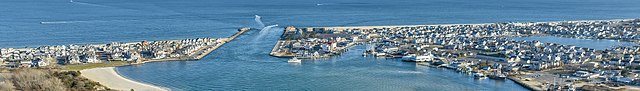
English: The Manasquan River flows into the Atlantic Ocean between Point Pleasant on the right, and Manasquan on the left. Manasquan is derived from "Menaskunk" of the Lenape Tribe Native American origin, meaning "Place to gather grass or reeds," |
| Date | |
| Source | https://www.flickr.com/photos/jal33/52560285356/ |
| Author | James Loesch |
| Other versions |

.jpg&action=edit§ion=1)
| Camera location | | View this and other nearby images on: OpenStreetMap |
|---|
.jpg¶ms=040.107487_N_-074.046615_E_globe:Earth_type:camera__&language=en)
Licensing
[edit].jpg&action=edit§ion=2)
This file is licensed under the Creative Commons Attribution 2.0 Generic license.
- You are free:
- to share – to copy, distribute and transmit the work
- to remix – to adapt the work
- Under the following conditions:
- attribution – You must give appropriate credit, provide a link to the license, and indicate if changes were made. You may do so in any reasonable manner, but not in any way that suggests the licensor endorses you or your use.
File history
Click on a date/time to view the file as it appeared at that time.
| Date/Time | Thumbnail | Dimensions | User | Comment | |
|---|---|---|---|---|---|
| current | 02:27, 15 January 2023 | 5,209 × 743 (4.05 MB) | ButteBag (talk | contribs) | File:Manasquan Inlet aerial photograph 2022.jpg cropped 75 % vertically using CropTool with precise mode. |
You cannot overwrite this file.
File usage on Commons
The following page uses this file:
File usage on other wikis
The following other wikis use this file:
- Usage on en.wikivoyage.org
.jpg&oldid=725238642)