File:Mammoth Lakes (Feb 2013) 05.JPG
Jump to navigation
Jump to search

Size of this preview: 800 × 545 pixels. Other resolutions: 320 × 218 pixels | 640 × 436 pixels | 1,024 × 698 pixels | 1,280 × 872 pixels | 2,560 × 1,744 pixels | 3,801 × 2,590 pixels.
Original file (3,801 × 2,590 pixels, file size: 4.74 MB, MIME type: image/jpeg)
Captions
Captions
Add a one-line explanation of what this file represents
Summary
[edit]| Description |
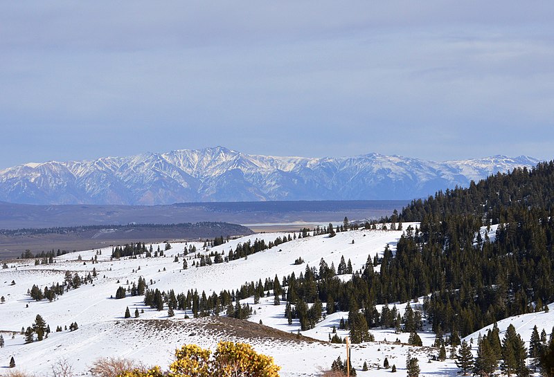
English: View of the White Mountains from a cliff in or just outside of the Old Mammoth area, near the south end of the town of Mammoth Lakes, California, U.S.A. You can see Mammoth Yosemite Airport and the Hot Creek State Fish Hatchery in front of the tree-covered hill (Doe Ridge[1]) on the left side of the screen. Behind Doe Ridge, the upper Owens River flows into Crowley Lake (frozen in this photo). The part that looks like a frozen stream is the "upper arm" of the lake, with the main body of the lake partially seen on right. The water flows from left (north) to right (south). The snowy, tree-covered slope in the foreground is at the northwest end of the Sherwin Range. The area that looks like a basin, including Doe Ridge, the hatchery, the airport and the upper arm of Crowley Lake (and Mammoth Mountain, which is not pictured here), is Long Valley Caldera. In other words, the photographer is standing near the southwest end of the caldera, between Mammoth Mountain (to the photographer's left) and the Sherwin Range. On the other side of the White Mountains is Nevada. 日本語: アメリカ合衆国カリフォルニア州マンモスレイクスの南側の町外れ付近、オールド・マンモス区域のさらに外れの崖から望むホワイト山脈。左側中央の木で覆われた丘(ドー・リッジ[2])の手前にマンモス・ヨセミテ空港とホット・クリーク州立養魚場が見える。ドー・リッジの向こう側に、オーエンズ川の上流がクローリー湖に流れ込む河口がある(オーエンズ川そのものはこの角度からは見えない)。凍った川のように見える部分は、湖の上流側(北側)の「上腕」部分で、右側(南側)に湖の「本体」の一部が見えている。手前の雪と木に覆われた坂はシャーウィン山脈の北西側始点付近。盆地状に見える範囲(ドー・リッジ、養魚場、空港とマンモス山を含む)はロングバレー・カルデラである。つまり、撮影者が立っている地点はロングバレー・カルデラの南西端付近で、マンモス山(撮影者の左方向にあるため、この写真では見えない)とシャーウィン山脈の間である。ホワイト山脈の向こう側はネバダ州。 |
| Date | |
| Source | Own work |
| Author | Nandaro |
| Other versions |
|
_06.JPG)
_05.JPG&action=edit§ion=1)
Licensing
[edit]_05.JPG&action=edit§ion=2)
I, the copyright holder of this work, hereby publish it under the following license:
This file is licensed under the Creative Commons Attribution-Share Alike 3.0 Unported license.
- You are free:
- to share – to copy, distribute and transmit the work
- to remix – to adapt the work
- Under the following conditions:
- attribution – You must give appropriate credit, provide a link to the license, and indicate if changes were made. You may do so in any reasonable manner, but not in any way that suggests the licensor endorses you or your use.
- share alike – If you remix, transform, or build upon the material, you must distribute your contributions under the same or compatible license as the original.
| Annotations | This image is annotated: View the annotations at Commons |
_05.JPG)
File history
Click on a date/time to view the file as it appeared at that time.
| Date/Time | Thumbnail | Dimensions | User | Comment | |
|---|---|---|---|---|---|
| current | 19:28, 19 February 2014 | | 3,801 × 2,590 (4.74 MB) | Nandaro (talk | contribs) | User created page with UploadWizard |
You cannot overwrite this file.
File usage on Commons
The following page uses this file:
File usage on other wikis
The following other wikis use this file:
- Usage on ja.wikipedia.org
_05.JPG&oldid=929757579)