File:Malepunyo Range Relief Map.png

Original file (1,920 × 1,920 pixels, file size: 3.66 MB, MIME type: image/png)
Captions
Captions
Summary
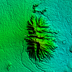
[edit]| Description |
English: Malepunyo Range Relief Map on 1 arc second/30-meter resolution from SRTM released September 23, 2014
Rectangular Projection based on coordinates
|
||||
| Date | |||||
| Source | Own work | ||||
| Author | Ervin Malicdem | ||||
| Permission (Reusing this file) |
I, the copyright holder of this work, hereby publish it under the following licenses:
This file is licensed under the Creative Commons Attribution-Share Alike 4.0 International license.
You may select the license of your choice.
|


Initially published at Schadow1 Expeditions article http://www.s1expeditions.com/2012/12/conquering-malarayat-mountain-range.html
File history
Click on a date/time to view the file as it appeared at that time.
| Date/Time | Thumbnail | Dimensions | User | Comment | |
|---|---|---|---|---|---|
| current | 05:25, 9 February 2015 | | 1,920 × 1,920 (3.66 MB) | Schadow1 (talk | contribs) | User created page with UploadWizard |
You cannot overwrite this file.
File usage on Commons
The following page uses this file:
File usage on other wikis
The following other wikis use this file:
- Usage on en.wikipedia.org