File:Mal 2023 path.png
Jump to navigation
Jump to search

Size of this preview: 782 × 600 pixels. Other resolutions: 313 × 240 pixels | 626 × 480 pixels | 1,002 × 768 pixels | 1,280 × 981 pixels | 2,560 × 1,963 pixels | 2,700 × 2,070 pixels.
Original file (2,700 × 2,070 pixels, file size: 342 KB, MIME type: image/png)
Captions
Captions
Add a one-line explanation of what this file represents
Summary
| Description |
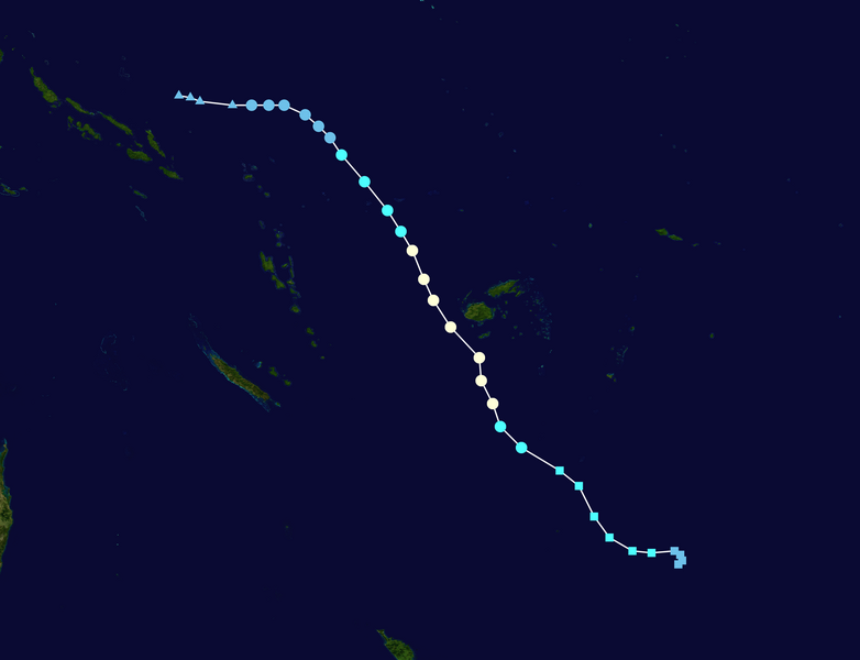
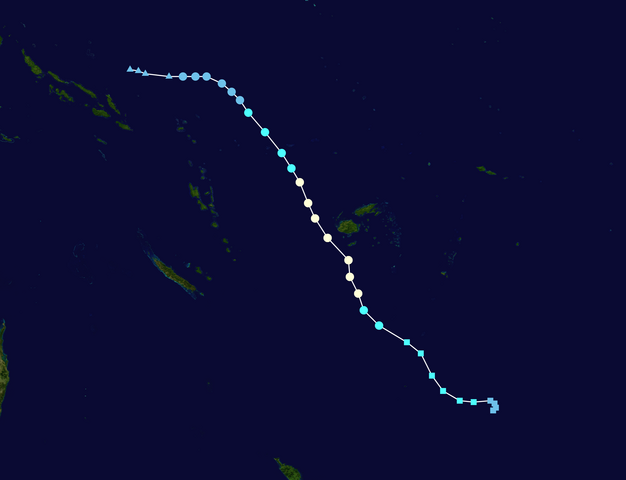
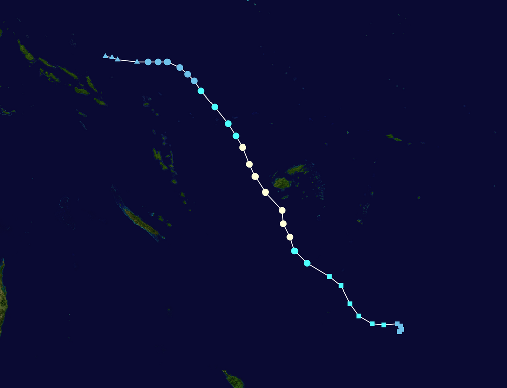
English: Track map of Severe Tropical Cyclone Mal of the 2023-24 South Pacific cyclone season. The points show the location of the storm at 6-hour intervals. The colour represents the storm's maximum sustained wind speeds as classified in the (see below), and the shape of the data points represent the nature of the storm, according to the legend below. Tropical depression (≤38 mph, ≤62 km/h)
Tropical storm (39–73 mph, 63–118 km/h)
Category 1 (74–95 mph, 119–153 km/h)
Category 2 (96–110 mph, 154–177 km/h)
Category 3 (111–129 mph, 178–208 km/h)
Category 4 (130–156 mph, 209–251 km/h)
Category 5 (≥157 mph, ≥252 km/h)
Unknown
Storm type |
||
| Date | 2023-11-10–2023-11-18 | ||
| Source | Created by Meow using Wikipedia:WikiProject Tropical cyclones/Tracks. The background image is from NASA. Tracking data is from NOAA. | ||
| Author | Meow | ||
| Source code | Track map data table, if present below, is in HURDAT2 or ATCF format. See format details in [1] and [2], respectively.
|
Licensing
[edit]| This work has been released into the public domain by its author, Meow. This applies worldwide. In some countries this may not be legally possible; if so: Meow grants anyone the right to use this work for any purpose, without any conditions, unless such conditions are required by law. |
Any autoconfirmed user can overwrite this file from the same source. Please ensure that overwrites comply with the guideline.
File history
Click on a date/time to view the file as it appeared at that time.
| Date/Time | Thumbnail | Dimensions | User | Comment | |
|---|---|---|---|---|---|
| current | 14:21, 18 November 2023 | | 2,700 × 2,070 (342 KB) | Meow (talk | contribs) | 11-18 12Z |
| 13:36, 17 November 2023 |  | 2,700 × 2,034 (401 KB) | Meow (talk | contribs) | 11-17 12Z | |
| 13:45, 16 November 2023 |  | 2,700 × 1,824 (559 KB) | Meow (talk | contribs) | 11-16 12Z | |
| 14:37, 15 November 2023 |  | 2,700 × 1,669 (605 KB) | Meow (talk | contribs) | 11-15 12Z | |
| 17:04, 14 November 2023 |  | 2,700 × 1,669 (621 KB) | Meow (talk | contribs) | 11-14 12Z | |
| 18:07, 13 November 2023 |  | 2,700 × 1,669 (603 KB) | Meow (talk | contribs) | 11-13 12Z | |
| 13:32, 12 November 2023 |  | 2,700 × 1,669 (672 KB) | Meow (talk | contribs) | 11-12 12Z | |
| 14:28, 11 November 2023 |  | 2,700 × 1,669 (885 KB) | Meow (talk | contribs) | {{WPTC track map | author = Meow | name = Tropical Disturbance 02F | article = 2023–24 South Pacific cyclone season#Tropical Disturbance 02F | season = 2023-24 South Pacific cyclone season | start = 2023-11-10 | end = | othersource = [https://www.ssd.noaa.gov/PS/TROP/DATA/ATCF/JTWC/bsh912024.dat NOAA] | colors = new }} |
You cannot overwrite this file.
File usage on Commons
The following 2 pages use this file:
- File:02F 2023 path.png (file redirect)
- Category:Cyclone Mal
File usage on other wikis
The following other wikis use this file:
- Usage on en.wikipedia.org
- Usage on ko.wikipedia.org
- Usage on vi.wikipedia.org
- Usage on www.wikidata.org
- Usage on zh.wikipedia.org