File:Making maps 130606-A-WF509-011.jpg
![File:Making maps 130606-A-WF509-011.jpg](https://upload.wikimedia.org/wikipedia/commons/thumb/6/6c/Making_maps_130606-A-WF509-011.jpg/800px-Making_maps_130606-A-WF509-011.jpg?20160926043800)
Original file (4,288 × 2,848 pixels, file size: 4.4 MB, MIME type: image/jpeg)
Captions
Captions
Summary
[edit]DescriptionMaking maps 130606-A-WF509-011.jpg |
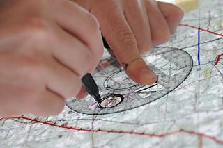
English: A close-up of map being constructed for the basic warfighter skills portion of rotary-wing flight training at Fort Rucker, Ala. Of all the tasks flights students must complete during flight school, making maps for BWS is among the most memorable due to the time required to construct quality maps. (U.S. Army photo by Sgt. 1st Class Andrew Kosterman)
Unit: Fort Rucker Public Affairs Office |
|||
Date | Taken on 6 June 2013 | |||
Source | https://www.dvidshub.net/image/965655/making-maps | |||
Author | Sgt. 1st Class Andrew Kosterman | |||
Location InfoField | FORT RUCKER, AL, US | |||
VIRIN InfoField |
|
|||
Posted InfoField | 3 July 2013, 17:39 | |||
Archive link InfoField | archive copy at the Wayback Machine |
Licensing
[edit]Public domainPublic domainfalsefalse |
![]() |
This file is a work of a U.S. Army soldier or employee, taken or made as part of that person's official duties. As a work of the U.S. federal government, it is in the public domain in the United States.
العربية ∙ বাংলা ∙ català ∙ čeština ∙ Deutsch ∙ English ∙ español ∙ eesti ∙ فارسی ∙ suomi ∙ français ∙ hrvatski ∙ magyar ∙ Bahasa Indonesia ∙ italiano ∙ 日本語 ∙ 한국어 ∙ lietuvių ∙ македонски ∙ മലയാളം ∙ မြန်မာဘာသာ ∙ Nederlands ∙ polski ∙ português ∙ русский ∙ sicilianu ∙ српски / srpski ∙ Türkçe ∙ українська ∙ Tiếng Việt ∙ 中文(简体) ∙ 中文(繁體) ∙ +/− |
![]() |
File history
Click on a date/time to view the file as it appeared at that time.
Date/Time | Thumbnail | Dimensions | User | Comment | |
---|---|---|---|---|---|
current | 04:38, 26 September 2016 | ![]() | 4,288 × 2,848 (4.4 MB) | Fæ (talk | contribs) | DVIDS 11 megapixel image from https://www.dvidshub.net/image/965655/making-maps, part of User:Fæ/Project list/DoD |
You cannot overwrite this file.
File usage on Commons
There are no pages that use this file.
Metadata
This file contains additional information such as Exif metadata which may have been added by the digital camera, scanner, or software program used to create or digitize it. If the file has been modified from its original state, some details such as the timestamp may not fully reflect those of the original file. The timestamp is only as accurate as the clock in the camera, and it may be completely wrong.
Image title |
|
---|---|
Camera manufacturer | NIKON CORPORATION |
Camera model | NIKON D300 |
Author | Andrew Kosterman |
Exposure time | 1/30 sec (0.033333333333333) |
F-number | f/5 |
ISO speed rating | 1,100 |
Date and time of data generation | 09:44, 6 June 2013 |
Lens focal length | 75 mm |
Short title | 130606-A-WF509-011 |
Headline | Making maps |
City shown | Fort Rucker |
Credit/Provider | U.S. Army |
Source | Digital |
Copyright holder | Public Domain |
Orientation | Normal |
Horizontal resolution | 300 dpi |
Vertical resolution | 300 dpi |
Software used | Adobe Photoshop CS3 Windows |
File change date and time | 14:32, 18 June 2013 |
Y and C positioning | Co-sited |
Exposure Program | Aperture priority |
Exif version | 2.21 |
Date and time of digitizing | 09:44, 6 June 2013 |
Meaning of each component |
|
Image compression mode | 2 |
APEX exposure bias | 0 |
Maximum land aperture | 4.7 APEX (f/5.1) |
Metering mode | Pattern |
Light source | Unknown |
Flash | Flash did not fire |
DateTime subseconds | 06 |
DateTimeOriginal subseconds | 06 |
DateTimeDigitized subseconds | 06 |
Supported Flashpix version | 1 |
Color space | sRGB |
Sensing method | One-chip color area sensor |
File source | Digital still camera |
Scene type | A directly photographed image |
Custom image processing | Normal process |
Exposure mode | Auto exposure |
White balance | Auto white balance |
Digital zoom ratio | 1 |
Focal length in 35 mm film | 112 mm |
Scene capture type | Standard |
Scene control | High gain up |
Contrast | Normal |
Saturation | Normal |
Sharpness | Normal |
Subject distance range | Unknown |
GPS tag version | 2.2.0.0 |
Width | 4,288 px |
Height | 2,848 px |
Pixel composition | RGB |
Number of components | 3 |
APEX shutter speed | 4.906891 |
APEX aperture | 4.643856 |
Supported Flashpix version | 1 |
Image width | 4,288 px |
Image height | 2,848 px |
Lens used | 18.0-200.0 mm f/3.5-5.6 |
Bits per component |
|
Date metadata was last modified | 09:32, 18 June 2013 |
Writer | Andrew Kosterman |
Keywords |
|
Province or state shown | AL |
Code for country shown | US |
Special instructions | Released
Sgt. 1st Class Andrew Kosterman Fort Rucker Public Affairs Office andrew.kosterman@us.army.mil via DVIDS |
Original transmission location code | U.S. Army |
Country shown | United States |