File:Major Tropical Cyclones of 2015 with text.jpg
Jump to navigation
Jump to search

Size of this preview: 800 × 416 pixels. Other resolutions: 320 × 166 pixels | 640 × 333 pixels | 1,024 × 532 pixels | 1,280 × 666 pixels | 2,560 × 1,331 pixels | 7,500 × 3,900 pixels.
Original file (7,500 × 3,900 pixels, file size: 32.31 MB, MIME type: image/jpeg)
Captions
Captions
Add a one-line explanation of what this file represents
Summary
[edit]| Description |
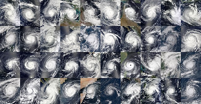
English: Taken by various satellites throughout 2015, these are the 40 tropical cyclones that reached at least Category 3 on the Saffir-Simpson scale during that year, from Bansi in January to Ula in December. However, it peaked in January 2016. The most intense tropical cyclone during 2015 and the second most intense globally on record was Patricia which is the third image in the fourth and final row, it had a pressure of 872 hPa and 1-minute sustained winds of 215 MPH (345 KMH), and a honorable mention goes to Tropical Cyclone Pam which was the second most intense of that year globally, but the most intense in the Southern hemisphere it had a pressure of 896 hPa and 1-minute sustained winds of 175 MPH (280 KMH), it is the sixth image in the first row. |
| Date | |
| Source | https://worldview.earthdata.nasa.gov/ & https://www.nnvl.noaa.gov/view/#TRUE & https://realearth.ssec.wisc.edu/ |
| Author | NASA, NOAA, and JMA (Image stitching by Cyclonetracker7586) |
Licensing
[edit]| This file is in the public domain in the United States because it was solely created by NASA. NASA copyright policy states that "NASA material is not protected by copyright unless noted". (See Template:PD-USGov, NASA copyright policy page or JPL Image Use Policy.) | ||
 |
Warnings:
|
This image is in the public domain because it contains materials that originally came from the U.S. National Oceanic and Atmospheric Administration, taken or made as part of an employee's official duties.
|
This image was produced by the Japan Meteorological Agency. The legal notice (archive) stated that all the images published on their website is compatible with the Creative Commons Attribution 4.0 License, which means that all the images on this website is published under the Creative Commons Attribution 4.0 License unless otherwise specified.
This file is licensed under the Creative Commons Attribution 4.0 International license. Attribution: Japan Meteorological Agency
|
 |

File history
Click on a date/time to view the file as it appeared at that time.
| Date/Time | Thumbnail | Dimensions | User | Comment | |
|---|---|---|---|---|---|
| current | 00:16, 25 January 2022 | | 7,500 × 3,900 (32.31 MB) | TheWxResearcher (talk | contribs) | Forgot Soudelor. |
| 23:58, 24 January 2022 |  | 7,500 × 3,900 (31.32 MB) | TheWxResearcher (talk | contribs) | Uploaded a work by NASA, NOAA, and JMA from https://worldview.earthdata.nasa.gov/ & https://www.nnvl.noaa.gov/view/#TRUE & https://realearth.ssec.wisc.edu/ with UploadWizard |
You cannot overwrite this file.
File usage on Commons
The following page uses this file:
File usage on other wikis
The following other wikis use this file:
- Usage on en.wikipedia.org