File:Mainzer Adelsverein Karte von Indian Point od. Indianola 1851 UTA.jpg
Original file (2,671 × 1,574 pixels, file size: 4.01 MB, MIME type: image/jpeg)
Captions
Captions
Summary
[edit]| Title |
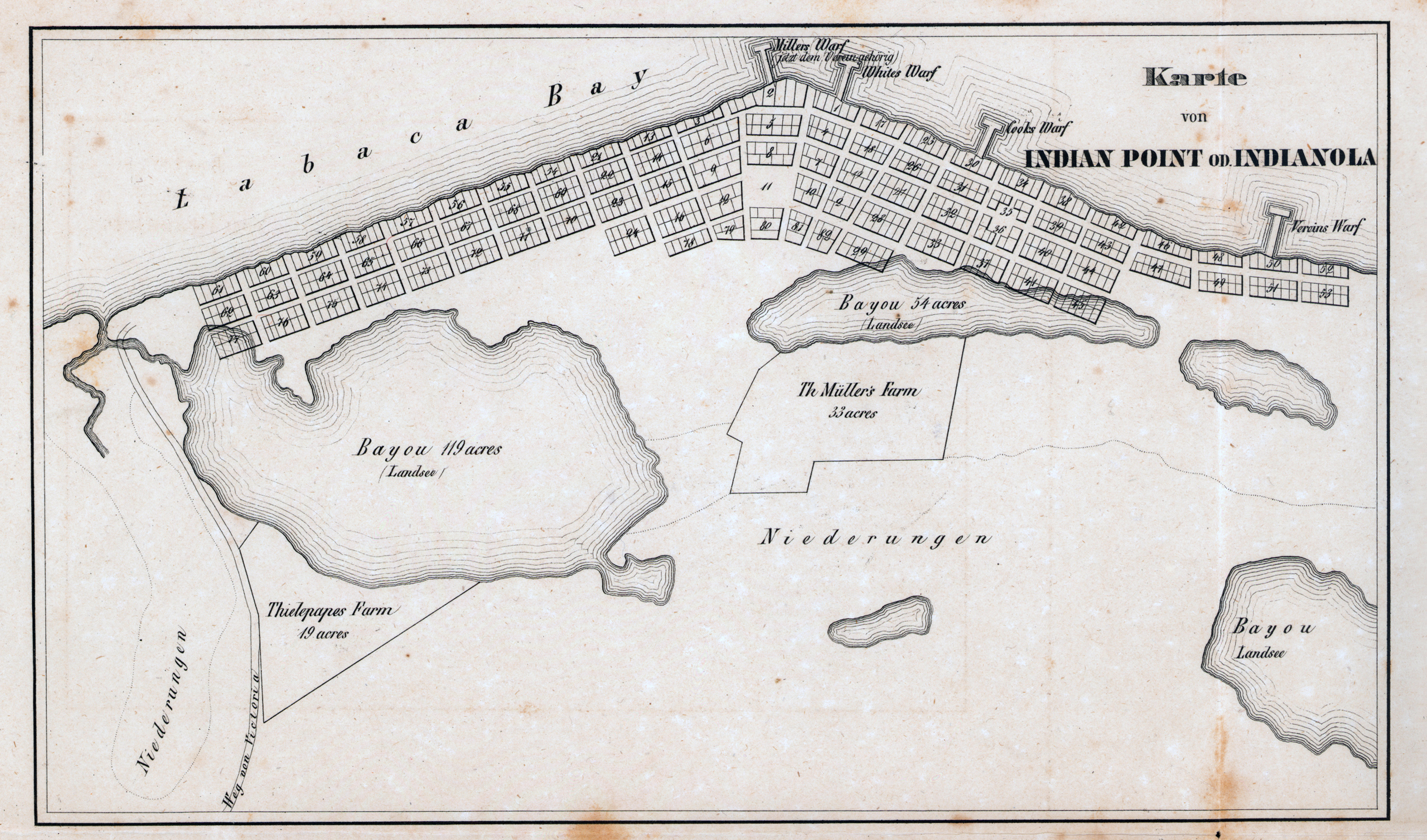
Deutsch: Karte von Indian Point od. Indianola |
||||||||||||||||||||||||||
| Description |
English: This town plan was part of a packet of materials published in 1851 by the Verein zum Schutze Deutscher Auswanderer nach Texas (Society for the Protection of German Emigrants to Texas, also known as the Adelsverein or Society of Nobles headquartered in Mainz and Wiesbaden). The port town and harbor of Indianola and the towns of New Braunfels and Fredericksburg all figured prominently in this project to settle hundreds of German emigrants in Texas during the 1840s and early 1850s. Employees of the Adelsverein who probably prepared these maps included Hermann Willke (ca.1822-after 1865), a young surveyor-engineer and Prussian army veteran and possibly Nicolaus Zink (1812-1887), also a surveyor-engineer and Bavarian army veteran who laid out the colony's town of New Braunfels. |
||||||||||||||||||||||||||
| Date | 1850–1851 | ||||||||||||||||||||||||||
| Source | UTA Libraries Cartographic Connections: map / text | ||||||||||||||||||||||||||
| Creator |
Adelsverein Hermann Willke
|
||||||||||||||||||||||||||
| Credit line |
English: The University of Texas at Arlington Libraries Special Collections |
||||||||||||||||||||||||||
| Geotemporal data | |||||||||||||||||||||||||||
| Map location | Indianola, Texas | ||||||||||||||||||||||||||
| Georeferencing | If inappropriate please set warp_status = skip to hide. | ||||||||||||||||||||||||||
| Bibliographic data | |||||||||||||||||||||||||||
| Place of publication | Wiesbaden | ||||||||||||||||||||||||||
| Publisher |
Verein zum Schutze Deutscher Auswanderer nach Texas |
||||||||||||||||||||||||||
| Printed by |
H. Delius, Berlin |
||||||||||||||||||||||||||
| Archival data | |||||||||||||||||||||||||||
| Collection |
|
||||||||||||||||||||||||||
| Dimensions | height: 27 cm (10.6 in); width: 39 cm (15.3 in) | ||||||||||||||||||||||||||
| Medium | lithograph on paper | ||||||||||||||||||||||||||
| artwork-references |
Huseman, Ben W. (2010) Charting Chartered Companies: Concessions to Companies as Mirrored in Maps, 1600-1900, Arlington: The University of Texas at Arlington Library, no. 40, 41 , pp. 32–34 Crystal Sasse Ragsdale (June 15, 2010). Zink, Nicolaus. Handbook of Texas Online. Texas State Historical Association. Retrieved on July 25, 2019. Biesele, Rudolph Leopold (1930) The History of the German Settlements in Texas 1831-1861, Austin: Von Boeckmann-Jones Co. |
||||||||||||||||||||||||||
| Other versions | |||||||||||||||||||||||||||

Licensing
[edit]

|
This file was provided to Wikimedia Commons by the University of Texas at Arlington Libraries as part of a cooperation project. The University of Texas at Arlington Libraries is part of the University of Texas at Arlington, a public research university located in Arlington, Texas.
|
|
The author died in 1887, so this work is in the public domain in its country of origin and other countries and areas where the copyright term is the author's life plus 100 years or fewer. This work is in the public domain in the United States because it was published (or registered with the U.S. Copyright Office) before January 1, 1929. | |
| This file has been identified as being free of known restrictions under copyright law, including all related and neighboring rights. | |
File history
Click on a date/time to view the file as it appeared at that time.
| Date/Time | Thumbnail | Dimensions | User | Comment | |
|---|---|---|---|---|---|
| current | 21:58, 26 July 2019 | | 2,671 × 1,574 (4.01 MB) | Michael Barera (talk | contribs) | == {{int:filedesc}} == {{Map |title = ''Karte von Indian Point od. Indianola'' |description = {{en|This town plan was part of a packet of materials published in 1851 by the ''Verein zum Schutze Deutscher Auswanderer nach Texas'' (Society for the Protection of German Emigrants to Texas, also known as the Adelsverein or Society of Nobles headquartered in Mainz and Wiesbaden). The port town and harbor of Indianola and the towns of New Braunfels and Fredericksburg all figured... |
You cannot overwrite this file.
File usage on Commons
The following page uses this file:
File usage on other wikis
The following other wikis use this file:
- Usage on de.wikipedia.org