File:Main Radweg Infotafel Bayreuth Auschnitt.jpg
Jump to navigation
Jump to search

Size of this preview: 800 × 232 pixels. Other resolutions: 320 × 93 pixels | 640 × 185 pixels | 2,128 × 616 pixels.
Original file (2,128 × 616 pixels, file size: 370 KB, MIME type: image/jpeg)
Captions
Captions
Add a one-line explanation of what this file represents
Summary
[edit]| Description |
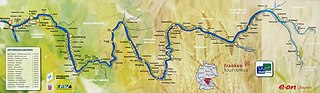
English: Map of Main-Radweg on an information board in Bayreuth
Deutsch: Karte des Main-Radwegs auf einer Infotafel in Bayreuth |
| Date | |
| Source | Own work |
| Author | Chianti |
| Other versions |
|

| Object location | | View this and other nearby images on: OpenStreetMap |
|---|
| Copyleft: This work of art is free; you can redistribute it and/or modify it according to terms of the Free Art License. You will find a specimen of this license on the Copyleft Attitude site as well as on other sites. |
|
The photographical reproduction of this work is covered under the article § 59 of the German copyright law, which states that "It shall be permissible to reproduce, by painting, drawing, photography or cinematography, works which are permanently located on public ways, streets or places and to distribute and publicly communicate such copies. For works of architecture, this provision shall be applicable only to the external appearance."
As with all other “limits of copyright by legally permitted uses”, no changes to the actual work are permitted under § 62 of the German copyright law (UrhG). See Commons:Copyright rules by territory/Germany#Freedom of panorama for more information.
|
File history
Click on a date/time to view the file as it appeared at that time.
| Date/Time | Thumbnail | Dimensions | User | Comment | |
|---|---|---|---|---|---|
| current | 20:43, 29 July 2019 | 2,128 × 616 (370 KB) | Chianti (talk | contribs) | {{Information |description ={{en|1=Map of Main-Radweg on an information board in Bayreuth}} {{de|1=Karte des Main-Radwegs auf einer Infotafel in Bayreuth}} |date =2019-07-29 |source ={{own}} |author =User:Chianti }} {{Object location|49.947229|11.577952}} {{FAL}} {{FOP-Germany}} Category:Main-Radweg Category:Information boards in Bayreuth |
You cannot overwrite this file.
File usage on Commons
The following 2 pages use this file:
File usage on other wikis
The following other wikis use this file:
- Usage on de.wikipedia.org
- Usage on de.wikivoyage.org
- Usage on www.wikidata.org