File:Magodayuyama Kofun Aerial photograph 2007.jpg
Jump to navigation
Jump to search
No higher resolution available.
Magodayuyama_Kofun_Aerial_photograph_2007.jpg (270 × 270 pixels, file size: 170 KB, MIME type: image/jpeg)
Captions
Captions
Add a one-line explanation of what this file represents
Summary
[edit]
| Description |
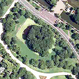
日本語: 大阪府堺市堺区夕雲町にある孫太夫山古墳の航空写真。国土地理院の航空写真CKK20071-C56-10から、Naokijpが作成。 |
| Date | |
| Source | 国土交通省 国土地理院 地図・空中写真閲覧サービス(https://mapps.gsi.go.jp/maplibSearch.do#1) |
| Author | 国土地理院 |
Licensing
[edit]

|
The copyright holder of this file, the Ministry of Land, Infrastructure, Transport and Tourism of Japan, allows anyone to use it for any purpose, provided that the copyright holder is properly attributed. Redistribution, derivative work, commercial use, and all other use is permitted. |
Attribution:
Copyright © National Land Image Information (Color Aerial Photographs), Ministry of Land, Infrastructure, Transport and Tourism
|
 |
This image is copyrighted by the Ministry of Land, Infrastructure, Transport and Tourism of Japan. For terms of use, see the stipulation to use of National Land Information (in Japanese) and message from MLIT (in Japanese and English). When you display this image on an article, include the following phrase in the description: "Made based on National Land Image Information (Color Aerial Photographs), Ministry of Land, Infrastructure, Transport and Tourism".
|
File history
Click on a date/time to view the file as it appeared at that time.
| Date/Time | Thumbnail | Dimensions | User | Comment | |
|---|---|---|---|---|---|
| current | 09:39, 19 July 2022 | | 270 × 270 (170 KB) | Naokijp (talk | contribs) | Uploaded a work by 国土地理院 from 国土交通省 国土地理院 地図・空中写真閲覧サービス(https://mapps.gsi.go.jp/maplibSearch.do#1) with UploadWizard |
You cannot overwrite this file.
File usage on Commons
The following page uses this file:
File usage on other wikis
The following other wikis use this file:
- Usage on ja.wikipedia.org
- Usage on www.wikidata.org
- Usage on zh.wikipedia.org