File:Ma Alalta.jpg
Jump to navigation
Jump to search
No higher resolution available.
Ma_Alalta.jpg (638 × 480 pixels, file size: 78 KB, MIME type: image/jpeg)
Captions
Captions
Add a one-line explanation of what this file represents
Summary
[edit]
| Description |
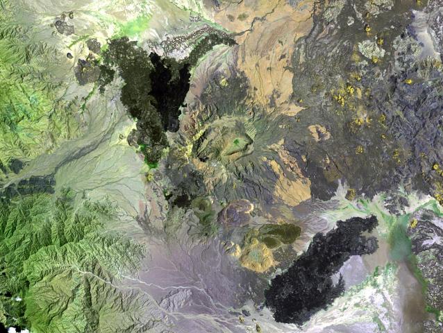
English: Ma Alalta volcano (center), also known as Pierre Pruvost, is an 1815-m-high stratovolcano located well to the west of the Danakil depression. A large trachytic and rhyolitic stratovolcano at the center of the Ma Alalta complex contains nested oval-shaped summit calderas, 6 km and 4 km wide in the long direction. Young basaltic lava flows were erupted on the NW, SE, and eastern flanks of the volcano, and young pantelleritic obsidian domes and lava flows were erupted on the volcano's southern flank. |
| Date | |
| Source | http://www.volcano.si.edu/world/volcano.cfm?vnum=0201-111&volpage=photos&photo=111080 |
| Author | NASA Landsat image (courtesy of Hawaii Synergy Project, Univ. of Hawaii Institute of Geophysics & Planetology) |
Licensing
[edit]
| This file is in the public domain in the United States because it was solely created by NASA. NASA copyright policy states that "NASA material is not protected by copyright unless noted". (See Template:PD-USGov, NASA copyright policy page or JPL Image Use Policy.) | ||
 |
Warnings:
|
File history
Click on a date/time to view the file as it appeared at that time.
| Date/Time | Thumbnail | Dimensions | User | Comment | |
|---|---|---|---|---|---|
| current | 18:40, 29 October 2010 | | 638 × 480 (78 KB) | Michael Metzger (talk | contribs) | {{Information |Description={{en|1=Ma Alalta volcano (center), also known as Pierre Pruvost, is an 1815-m-high stratovolcano located well to the west of the Danakil depression. A large trachytic and rhyolitic stratovolcano at the center of the Ma Alalta co |
You cannot overwrite this file.
File usage on Commons
There are no pages that use this file.
File usage on other wikis
The following other wikis use this file:
- Usage on bg.wikipedia.org
- Usage on ca.wikipedia.org
- Usage on ceb.wikipedia.org
- Usage on de.wikipedia.org
- Usage on en.wikipedia.org
- Usage on es.wikipedia.org
- Usage on fr.wikipedia.org
- Usage on lld.wikipedia.org
- Usage on sk.wikipedia.org
- Usage on sv.wikipedia.org
- Usage on sw.wikipedia.org
- Usage on www.wikidata.org
- Usage on zh.wikipedia.org
Metadata
Categories:
- Volcanoes in Ethiopia
- Stratovolcanoes in Ethiopia
- Lava flows in Ethiopia
- Satellite pictures of volcanoes in Ethiopia
- Rhyolite volcanoes in Ethiopia
- Calderas in Ethiopia
- Lava fields in Ethiopia
- Obsidian lava fields
- Trachyte volcanoes in Africa
- Nested calderas in Africa
- Obsidian lava domes
- Lava domes in Ethiopia
- Felsic volcanism in Ethiopia