File:MTN25-0400c1-2014-Valdestillas.jpg
Jump to navigation
Jump to search

Size of this preview: 800 × 576 pixels. Other resolutions: 320 × 230 pixels | 640 × 461 pixels | 1,024 × 738 pixels | 1,280 × 922 pixels | 2,560 × 1,844 pixels | 7,185 × 5,175 pixels.
Original file (7,185 × 5,175 pixels, file size: 19.01 MB, MIME type: image/jpeg)
Captions
Captions
Add a one-line explanation of what this file represents
Summary
[edit]
| Title |
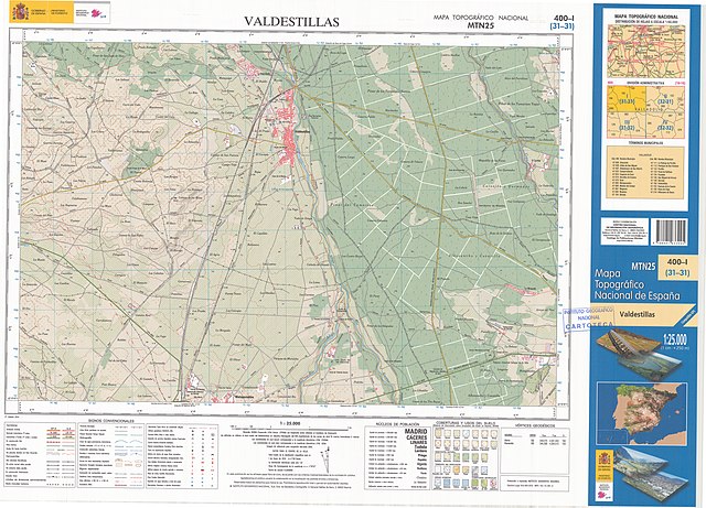
Mapa MTN25-0400c1-2014-Valdestillas |
||||||||||||||||||||
| Description |
Español: Fragmento 0400c1 del Mapa Topográfico Nacional de España del año 2014 a escala 1:25000 impreso y escaneado a 250 ppp. Se representa Valdestillas. English: Fragment 0400c1 of the National Topographic Map of Spain in 2014 at a scale of 1:25000 printed and scanned with a resolution of 250 ppi. It shows Valdestillas. |
||||||||||||||||||||
| Date | |||||||||||||||||||||
| Source | https://centrodedescargas.cnig.es/CentroDescargas/ | ||||||||||||||||||||
| Creator |
|
||||||||||||||||||||
| Permission (Reusing this file) |
This file is licensed under the Creative Commons Attribution 4.0 International license. Attribution: Instituto Geográfico Nacional (archived version)
|
||||||||||||||||||||
| Geotemporal data | |||||||||||||||||||||
| Map location | Valdestillas (Q1766688) | ||||||||||||||||||||
| Map type | topographic map (Q216526) | ||||||||||||||||||||
| Scale | 1:25,000 | ||||||||||||||||||||
| Georeferencing | If inappropriate please set warp_status = skip to hide. | ||||||||||||||||||||
| Bibliographic data | |||||||||||||||||||||
| Part of the series | National Topographic Map 1:25000 printed (Q60543124) | ||||||||||||||||||||
| Map sheet | 0400c1 | ||||||||||||||||||||
| Language | Spanish | ||||||||||||||||||||
| Place of publication | Madrid (Q2807) | ||||||||||||||||||||
| Publisher |
|
||||||||||||||||||||
| Archival data | |||||||||||||||||||||
| Collection |
|
||||||||||||||||||||
| Notes |
|
||||||||||||||||||||
Licensing
[edit]
This file is licensed under the Creative Commons Attribution 4.0 International license.
- You are free:
- to share – to copy, distribute and transmit the work
- to remix – to adapt the work
- Under the following conditions:
- attribution – You must give appropriate credit, provide a link to the license, and indicate if changes were made. You may do so in any reasonable manner, but not in any way that suggests the licensor endorses you or your use.
File history
Click on a date/time to view the file as it appeared at that time.
| Date/Time | Thumbnail | Dimensions | User | Comment | |
|---|---|---|---|---|---|
| current | 06:03, 1 February 2019 | | 7,185 × 5,175 (19.01 MB) | Abián (talk | contribs) | == {{int:description}} == {{Map |title = Mapa MTN25-0400c1-2014-Valdestillas |description = {{es|Fragmento 0400c1 del Mapa Topográfico Nacional de España del año 2014 a escala 1:25000 impreso y escaneado a 250 ppp. Se representa Valdestillas.}}{{en|Fragment 0400c1 of the National Topographic Map of Spain in 2014 at a scale of 1:25000 printed and scanned with a resolution of 250 ppi. It shows Valdestillas.}} |legend = |author = {{Creator:Centro Naci... |
You cannot overwrite this file.
File usage on Commons
There are no pages that use this file.
File usage on other wikis
The following other wikis use this file:
- Usage on es.wikipedia.org