File:MORRO DA IGREJA, NA SERRA DO CORVO BRANCO EM URUBICI-SC, BRAZIL 02.jpg
Jump to navigation
Jump to search

Size of this preview: 800 × 451 pixels. Other resolutions: 320 × 180 pixels | 640 × 361 pixels | 1,024 × 578 pixels | 1,280 × 722 pixels | 2,436 × 1,374 pixels.
Original file (2,436 × 1,374 pixels, file size: 2.67 MB, MIME type: image/jpeg)
Captions
Captions
Add a one-line explanation of what this file represents
Summary
[edit]
| Description |
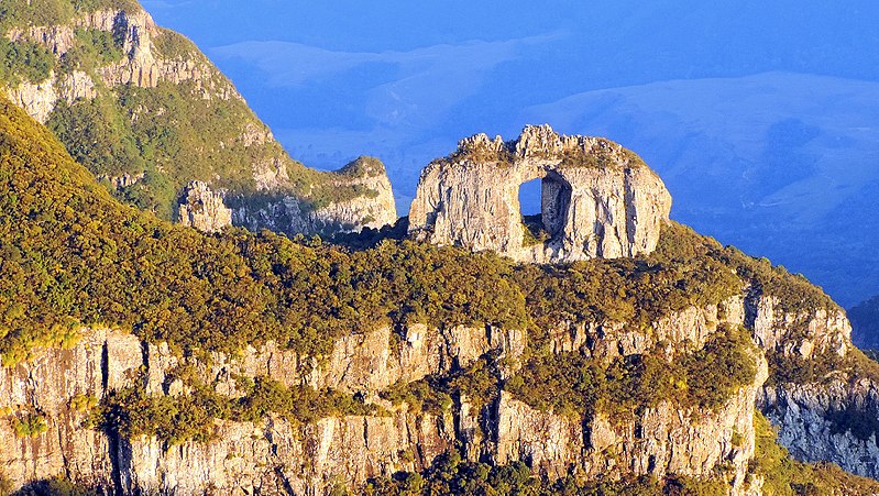
Português: Para fazer a visitação ao Morro da Igreja, precisa de autorização no ICMBio, pelo fone (49) 3278-4994 ou por e-mail: agendamentoparque@hotmail.com, sem cobrança. Localizado a 29 km do centro de Urubici, o morro sedia uma base de aeronáutica que controla o espaço aéreo de Santa Catarina e do Rio Grande do Sul. É o ponto habitado mais alto do sul do Brasil. Ali foi registrada a temperatura oficial mais fria do país - 17,8 graus negativos, em 1996.
O vento intermitente dá a sensação de frio ainda mais intenso. Em todos os invernos há, invariavelmente, ocorrência de neve. É um passeio imperdível e de fácil acesso quando o tempo está bom - a subida do morro, cujo topo está a 1.822 metros de altura, é asfaltada. Do alto tem-se uma visão privilegiada da Pedra Furada, interessante formação que se assemelha a uma grande janela natural. Não esqueça de levar agasalhos, porque baixas temperaturas são comuns mesmo no verão. Para evitar neblina, o melhor horário de visitação é entre as 10h e as 15h. Os visitantes podem passar a primeira porteira, que geralmente encontra-se aberta, mas não têm permissão para entrar na área da aeronáutica, a partir da segunda porteira, que permanece fechada e com segurança em tempo integral.
English: To make the visitation to Morro da Igreja, you need authorization at ICMBio, by phone (49) 3278-4994 or by e-mail: agendamentoparque@hotmail.com, without charge. Located 29 km from the center of Urubici, the hill hosts an aeronautical base that controls the air space of Santa Catarina and Rio Grande do Sul. It is the highest inhabited spot in southern Brazil. There, the coldest official temperature of the country was registered - minus 17.8 degrees in 1996.
The intermittent wind gives the feeling of even more intense cold. In all winters there is invariably snowfall. It is a must-see and easily accessible tour in good weather - the ascent of the hill, whose top is 1,822 meters high, is paved. From the top there is a privileged view of Pedra Furada, an interesting formation that resembles a large natural window. Do not forget to bring warm clothes, because low temperatures are common even in summer. To avoid fog, the best visitation time is between 10am and 3pm. Visitors can pass the first gate, which is usually open, but is not allowed to enter the aeronautics area, from the second gate, which remains closed and full time security. |
| Date | |
| Source | Own work |
| Author | EDI GALVANI ULIANO |
Licensing
[edit]
I, the copyright holder of this work, hereby publish it under the following license:
This file is licensed under the Creative Commons Attribution-Share Alike 4.0 International license.
- You are free:
- to share – to copy, distribute and transmit the work
- to remix – to adapt the work
- Under the following conditions:
- attribution – You must give appropriate credit, provide a link to the license, and indicate if changes were made. You may do so in any reasonable manner, but not in any way that suggests the licensor endorses you or your use.
- share alike – If you remix, transform, or build upon the material, you must distribute your contributions under the same or compatible license as the original.
File history
Click on a date/time to view the file as it appeared at that time.
| Date/Time | Thumbnail | Dimensions | User | Comment | |
|---|---|---|---|---|---|
| current | 13:59, 1 September 2017 | | 2,436 × 1,374 (2.67 MB) | ULIANO EDI (talk | contribs) | User created page with UploadWizard |
You cannot overwrite this file.
File usage on Commons
There are no pages that use this file.