File:MH370 map.svg
Jump to navigation
Jump to search

Size of this PNG preview of this SVG file: 375 × 600 pixels. Other resolutions: 150 × 240 pixels | 300 × 480 pixels | 480 × 768 pixels | 640 × 1,024 pixels | 1,280 × 2,048 pixels | 512 × 819 pixels.
Original file (SVG file, nominally 512 × 819 pixels, file size: 222 KB)
Captions
Captions
Add a one-line explanation of what this file represents
Summary
[edit]
| Description |
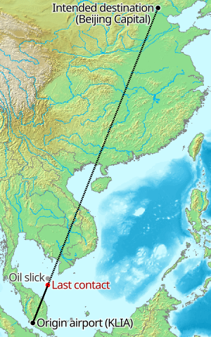
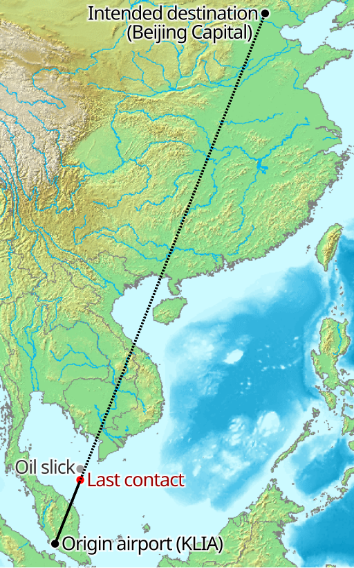
English: Map of Malaysia Airlines MH370 path. |
| Date | |
| Source | DEMIS World Map Server |
| Author | http://www2.demis.nl/mapserver/wms.asp?VERSION=1.1.0&REQUEST=GetMap&SRS=EPSG:4326&BBOX=59.7375759966999,-7.36599696909886,149.737575996699,54.0529219498195&WIDTH=1628&HEIGHT=1111&LAYERS=Bathymetry,Countries,Topography,Hillshading,Coastlines,Rivers,Borders&STYLES=,,,,,,&BGCOLOR=0xCEFFFF&FORMAT=image/gif&TRANSPARENT=FALSE&WRAPDATELINE=TRUE |
| Other versions | File:Malaysia Airlines MH370 path labelled.svg |
Licensing
[edit]
This image is in the public domain because it came from the site https://www.demis.nl/products/web-map-server/examples/ and was released by the copyright holder. Permission is granted to copy, distribute and/or modify this map since it is based on free of copyright images from: www.demis.nl. See also approval email on de.wp and its clarification.
|
| This work has been released into the public domain by its copyright holder, www.demis.nl. This applies worldwide. In some countries this may not be legally possible; if so: www.demis.nl grants anyone the right to use this work for any purpose, without any conditions, unless such conditions are required by law.
|
| This file is made available under the Creative Commons CC0 1.0 Universal Public Domain Dedication. | |
| The person who associated a work with this deed has dedicated the work to the public domain by waiving all of their rights to the work worldwide under copyright law, including all related and neighboring rights, to the extent allowed by law. You can copy, modify, distribute and perform the work, even for commercial purposes, all without asking permission.
|
File history
Click on a date/time to view the file as it appeared at that time.
| Date/Time | Thumbnail | Dimensions | User | Comment | |
|---|---|---|---|---|---|
| current | 13:47, 11 March 2014 | | 512 × 819 (222 KB) | Cmglee (talk | contribs) | User created page with UploadWizard |
You cannot overwrite this file.
File usage on Commons
The following 2 pages use this file:
File usage on other wikis
The following other wikis use this file:
- Usage on en.wikipedia.org