File:MH17 map-en.svg
From Wikimedia Commons, the free media repository
(Redirected from File:MH17 map.svg)

Size of this PNG preview of this SVG file: 512 × 256 pixels. Other resolutions: 320 × 160 pixels | 640 × 320 pixels | 1,024 × 512 pixels | 1,280 × 640 pixels | 2,560 × 1,280 pixels.
Original file (SVG file, nominally 512 × 256 pixels, file size: 212 KB)
File information
Structured data
Captions
Captions
Add a one-line explanation of what this file represents
Summary
[edit]| DescriptionMH17 map-en.svg |
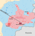
English: Route map of Malaysia Airlines Flight 17; takeoff and last contact times as to DSB report. [1][2] |
|
| Date | ||
| Source |
|
|
| Author | Geordie Bosanko and cmglee | |
| Other versions |
[edit] English: Base maps
English: Other maps
|
|
| SVG development InfoField |
Licensing
[edit]This file is licensed under the Creative Commons Attribution-Share Alike 3.0 Unported license.
- You are free:
- to share – to copy, distribute and transmit the work
- to remix – to adapt the work
- Under the following conditions:
- attribution – You must give appropriate credit, provide a link to the license, and indicate if changes were made. You may do so in any reasonable manner, but not in any way that suggests the licensor endorses you or your use.
- share alike – If you remix, transform, or build upon the material, you must distribute your contributions under the same or compatible license as the original.
File history
Click on a date/time to view the file as it appeared at that time.
| Date/Time | Thumbnail | Dimensions | User | Comment | |
|---|---|---|---|---|---|
| current | 16:44, 13 March 2023 |  | 512 × 256 (212 KB) | Tyrrrz (talk | contribs) | Corrected transliteration of Ukrainian capital |
| 16:14, 15 September 2014 |  | 512 × 256 (212 KB) | PM3 (talk | contribs) | fixed takeoff and last contact times, see [http://www.onderzoeksraad.nl/en/onderzoek/2049/investigation-crash-mh17-17-july-2014/preliminary-report#fasen] | |
| 07:35, 10 September 2014 |  | 512 × 256 (212 KB) | Wereldburger758 (talk | contribs) | Valid SVG now. | |
| 13:21, 18 July 2014 |  | 512 × 256 (231 KB) | Matthiasb (talk | contribs) | 1315 UTC is correct, 1415 GMT is wrong for 1415 WEST | |
| 03:53, 18 July 2014 |  | 512 × 256 (231 KB) | Maxdamantus (talk | contribs) | Original times seem to be more accurate. | |
| 20:40, 17 July 2014 |  | 512 × 256 (231 KB) | Cmglee (talk | contribs) | Fix times and font. | |
| 20:36, 17 July 2014 |  | 512 × 256 (231 KB) | Cmglee (talk | contribs) | User created page with UploadWizard |
You cannot overwrite this file.
File usage on Commons
The following 53 pages use this file:
- July 2014
- User:Cmglee/svg
- User:Magog the Ogre/Maps of conflicts/2023 March
- Commons:Graphic Lab/Map workshop/Archive/2016
- Commons:WikiProject Aviation/recent uploads/2014 July 17
- File:MH17-Route 13z20.svg
- File:MH17 map-cs.svg
- File:MH17 map-de.svg
- File:MH17 map-en.svg
- File:MH17 map-es.svg
- File:MH17 map-fi.svg
- File:MH17 map-fr.svg
- File:MH17 map-he.svg
- File:MH17 map-hu.svg
- File:MH17 map-it.svg
- File:MH17 map-ja.svg
- File:MH17 map-lv.svg
- File:MH17 map-nl.svg
- File:MH17 map-ru.svg
- File:MH17 map-uk.svg
- File:MH17 map-zh-hans.svg
- File:MH17 map-zh-hant.svg
- File:MH17 map-zh-tw.svg
- File:MH17 map.svg (file redirect)
- File:MH17 map-en.svg
- File:MH17 map-cs.svg
- File:MH17 map-es.svg
- File:MH17 map-nl.svg
- File:MH17 map-de.svg
- Commons:WikiProject Aviation/recent uploads/2014 July 17
- File:MH17 map-uk.svg
- File:MH17 map-zh-hans.svg
- File:MH17 map-zh-hant.svg
- File:MH17 map-fr.svg
- File:MH17 map-ru.svg
- File:MH17-Route 13z20.svg
- File:MH17 map-hu.svg
- File:Malaysia Airlines Flight 17 crash site.png
- File:MH17 map-it.svg
- File:MH17 map-ja.svg
- File:MH17 map-zh-tw.svg
- Template:Other versions/MH17
- File:Malaysia Airlines Flight 17 crash site without launcher position.png
- File:Malaysia Airlines Flight 17 crash site IT.png
- File:MH17 map-fi.svg
- File:MH17 map-lv.svg
- File:MH17 map-he.svg
- File:Malaysia Airlines Flight 17 crash site.png
- File:Malaysia Airlines Flight 17 crash site IT.png
- File:Malaysia Airlines Flight 17 crash site without launcher position.png
- Template:Other versions/MH17
- Category:Malaysia Airlines Flight 17
- Category:Victims of 2014 Malaysia Airlines Flight 17 crash
File usage on other wikis
The following other wikis use this file:
- Usage on ar.wikipedia.org
- Usage on bar.wikipedia.org
- Usage on bat-smg.wikipedia.org
- Usage on be-tarask.wikipedia.org
- Usage on be.wikipedia.org
- Usage on bg.wikipedia.org
- Usage on bs.wikipedia.org
- Usage on ca.wikipedia.org
- Usage on da.wikipedia.org
- Usage on en.wikipedia.org
- Usage on en.wikinews.org
- Usage on eo.wikipedia.org
- Usage on es.wikipedia.org
- Usage on et.wikipedia.org
- Usage on eu.wikipedia.org
- Usage on fa.wikipedia.org
- Usage on fr.wikinews.org
- Usage on fy.wikipedia.org
- Usage on ga.wikipedia.org
- Usage on hr.wikipedia.org
- Usage on id.wikipedia.org
- Usage on kk.wikipedia.org
- Usage on km.wikipedia.org
- Usage on ko.wikipedia.org
- Usage on lt.wikipedia.org
- Usage on mr.wikipedia.org
- Usage on ms.wikipedia.org
- Usage on my.wikipedia.org
- Usage on nl.wikinews.org
- Usage on no.wikipedia.org
- Usage on oc.wikipedia.org
- Usage on pl.wikipedia.org
- Usage on pnb.wikipedia.org
- Usage on pt.wikipedia.org
- Usage on ro.wikipedia.org
- Usage on sco.wikipedia.org
- Usage on sh.wikipedia.org
- Usage on simple.wikipedia.org
- Usage on si.wikipedia.org
- Usage on sk.wikipedia.org
- Usage on sr.wikipedia.org
- Usage on sr.wikinews.org
- Usage on sv.wikipedia.org
View more global usage of this file.
Metadata
This file contains additional information such as Exif metadata which may have been added by the digital camera, scanner, or software program used to create or digitize it. If the file has been modified from its original state, some details such as the timestamp may not fully reflect those of the original file. The timestamp is only as accurate as the clock in the camera, and it may be completely wrong.
| Width | 100% |
|---|---|
| Height | 100% |


