File:MH17 map.png
Jump to navigation
Jump to search

Size of this preview: 800 × 485 pixels. Other resolutions: 320 × 194 pixels | 640 × 388 pixels | 1,243 × 753 pixels.
Original file (1,243 × 753 pixels, file size: 1.08 MB, MIME type: image/png)
Captions
Captions
Add a one-line explanation of what this file represents
Summary
[edit]
| Description |
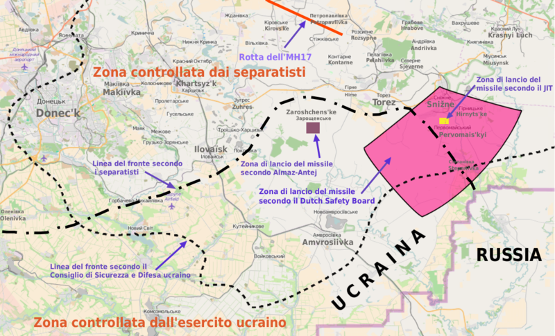
Italiano: Volo Malaysia Airlines 17: rotta del volo, linea del fronte, zona di lancio del missile secondo Onderzoeksraad voor Veiligheid, Almaz-Antej e JIT. Dati da Onderzoeksraad voor Veiligheid, Almaz-Antej, JIT, BBC, New York Times, Rusvesna, National Security and Defense Council of Ukraine. Mappa derivata da OpenStreetMap. |
|||
| Date | ||||
| Source | Own work | |||
| Author | Antonioptg | |||
| Permission (Reusing this file) |
|
Licensing
[edit]
I, the copyright holder of this work, hereby publish it under the following licenses:

|
Permission is granted to copy, distribute and/or modify this document under the terms of the GNU Free Documentation License, Version 1.2 or any later version published by the Free Software Foundation; with no Invariant Sections, no Front-Cover Texts, and no Back-Cover Texts. A copy of the license is included in the section entitled GNU Free Documentation License. |
This file is licensed under the Creative Commons Attribution-Share Alike 4.0 International, 3.0 Unported, 2.5 Generic, 2.0 Generic and 1.0 Generic license.
- You are free:
- to share – to copy, distribute and transmit the work
- to remix – to adapt the work
- Under the following conditions:
- attribution – You must give appropriate credit, provide a link to the license, and indicate if changes were made. You may do so in any reasonable manner, but not in any way that suggests the licensor endorses you or your use.
- share alike – If you remix, transform, or build upon the material, you must distribute your contributions under the same or compatible license as the original.
You may select the license of your choice.
File history
Click on a date/time to view the file as it appeared at that time.
| Date/Time | Thumbnail | Dimensions | User | Comment | |
|---|---|---|---|---|---|
| current | 18:14, 28 September 2016 | | 1,243 × 753 (1.08 MB) | Antonioptg (talk | contribs) | {{Information |Description ={{it|1=Volo Malaysia Airlines 17: rotta del volo, linea del fronte, zona di lancio del missile secondo Onderzoeksraad voor Veiligheid, Almaz-Antej e JIT ; dati da Onderzoeksraad voor Veiligheid, Almaz-Antej, JIT, [http:/... |
You cannot overwrite this file.
File usage on Commons
The following 2 pages use this file:
File usage on other wikis
The following other wikis use this file:
- Usage on it.wikipedia.org
- Usage on ru.wikinews.org