File:Młynarze (gmina) location map.png
Jump to navigation
Jump to search

Size of this preview: 698 × 600 pixels. Other resolutions: 280 × 240 pixels | 559 × 480 pixels | 801 × 688 pixels.
Original file (801 × 688 pixels, file size: 91 KB, MIME type: image/png)
Captions
Captions
Add a one-line explanation of what this file represents
| Description |
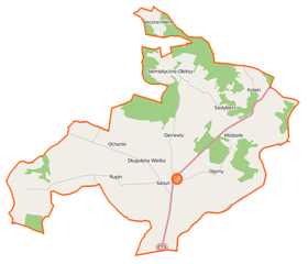
Polski: Mapa gminy Młynarze, Polska
English: Map of Gmina Młynarze, Poland |
|||||||||
| Date | ||||||||||
| Source | You may find a page on the OpenStreetMap wiki page for Młynarze (gmina) | |||||||||
| Creator |
OpenStreetMap contributors OpenStreetMap contributors |
|||||||||
| Permission (Reusing this file) |
OpenStreetMap data is available under the Open Database License (details). Map tiles are licensed under the Creative Commons Attribution-ShareAlike 2.0 license (CC-BY-SA 2.0).
This file is licensed under the Creative Commons Attribution-Share Alike 2.0 Generic license.
|
|||||||||
| Geotemporal data | ||||||||||
| Bounding box |
|
|||||||||
| Georeferencing | If inappropriate please set warp_status = skip to hide. | |||||||||
File history
Click on a date/time to view the file as it appeared at that time.
| Date/Time | Thumbnail | Dimensions | User | Comment | |
|---|---|---|---|---|---|
| current | 10:48, 12 September 2014 | | 801 × 688 (91 KB) | VanWiel (talk | contribs) | {{Information |Description= |Source= |Date= |Author= |Permission= |other_versions= }} |
| 05:42, 5 August 2014 |  | 801 × 688 (125 KB) | VanWiel (talk | contribs) | {{OpenStreetMap | name = Młynarze (gmina) | location = Młynarze (gmina) | description = {{pl|Mapa gminy Młynarze, Polska}} {{en|Map of Gmina Młynarze, Poland}} | top = 53.0286 | left = 21.2833... |
You cannot overwrite this file.
File usage on Commons
There are no pages that use this file.
File usage on other wikis
The following other wikis use this file:
- Usage on fr.wikipedia.org
- Usage on nl.wikipedia.org
- Usage on pl.wikipedia.org
- Młynarze (gmina)
- Długołęka-Koski
- Długołęka Wielka
- Głażewo-Cholewy
- Głażewo-Święszki
- Ochenki
- Ogony
- Sieluń
- Strzemieczne-Hieronimy
- Strzemieczne-Oleksy
- Strzemieczne-Wiosny
- Załęże-Ponikiewka
- Kołaki (województwo mazowieckie)
- Modzele (województwo mazowieckie)
- Gierwaty (powiat makowski)
- Młynarze (powiat makowski)
- Rupin (powiat makowski)
- Sadykierz (powiat makowski)
- Parafia św. Stanisława Biskupa i Męczennika w Sieluniu
- Moduł:Mapa/dane/Młynarze (gmina)
- Kościół św. Stanisława w Sieluniu
- Usage on pl.wikibooks.org
_location_map.png&oldid=942133984)