File:Měšín 1764.png
Jump to navigation
Jump to search

Size of this preview: 800 × 373 pixels. Other resolutions: 320 × 149 pixels | 640 × 298 pixels | 1,030 × 480 pixels.
Original file (1,030 × 480 pixels, file size: 1.33 MB, MIME type: image/png)
Captions
Captions
Add a one-line explanation of what this file represents
Summary
[edit]
| Description |
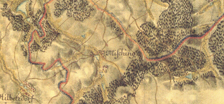
Čeština: Měšín (okres Jihlava) a jeho okolí - I. vojenské mapování – josefské (1764–1768, 1780–1783). |
| Date | 1764–1768 and 1780–1783 |
| Source | http://oldmaps.geolab.cz/map_viewer.pl?z_height=600&lang=en&z_width=1400&z_newwin=1&map_root=1vm&map_region=ce&map_list=c215 |
| Author |
|
Licensing
[edit]
|
This work is in the public domain in its country of origin and other countries and areas where the copyright term is the author's life plus 70 years or fewer. | |
| This file has been identified as being free of known restrictions under copyright law, including all related and neighboring rights. | |
File history
Click on a date/time to view the file as it appeared at that time.
| Date/Time | Thumbnail | Dimensions | User | Comment | |
|---|---|---|---|---|---|
| current | 13:27, 11 August 2013 | | 1,030 × 480 (1.33 MB) | Jana Lánová (talk | contribs) | User created page with UploadWizard |
You cannot overwrite this file.
File usage on Commons
There are no pages that use this file.
File usage on other wikis
The following other wikis use this file:
- Usage on cs.wikipedia.org