File:Mönarpa mossar på SV Falbygden 1-40000.jpg
Jump to navigation
Jump to search

Size of this preview: 502 × 599 pixels. Other resolutions: 201 × 240 pixels | 402 × 480 pixels | 840 × 1,002 pixels.
Original file (840 × 1,002 pixels, file size: 565 KB, MIME type: image/jpeg)
Captions
Captions
Add a one-line explanation of what this file represents
Summary
[edit]
| Description |
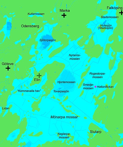
English: Map over the bog complex Mönarpa mossar (Mönarp's bogs) in the municipality of Falköping, Västergötland (Westrogothia), Sweden. Scale 1:40,000. Land is green. Lakes and watercourses are blue. Bogs are lighter blue. Drained peat soil is lightest blue. The site, where the Neolithic skeleton called "The Raspberry Girl" (Hallonflickan) was found, is marked magenta
Svenska: Karta över mosskomplexet Mönarpa mossar i Falköpings kommun, Västergötland, Sverige. Skala 1:40000. Kartan är gjord utifrån Geologiska kartan från 1905. Fastlandet är grönt. Nuvarande sjöar och vattendrag är blå. Mossar är ljusare blå. Utdikad mossmark är ljusast blå. Namngivna i kursiv stil är ån Lidan, sjöarna Sjötorpasjön, Tovarpasjön och Hulesjön, samt mossarna Mönarpa mossar, Hjortemossen, Smedjemossen, Rogestorpamossen, Nyhems mossar och Stadsmossen. Den neolitiska Hallonflickans fyndplats är markerad med magenta. För orienteringen är Göteve kyrka, Marka kyrka och Falköpings S:t Olofs kyrka markerade med svarta kors. Elins ödekyrka är markerad med ett grått kors. Namnen på samhällena Odensberg och Slutarp är också utsatta för att underlätta orientering. |
| Date | |
| Source | Own work based on the Geological map from 1905. |
| Author | Gunnar Creutz (Achird) |
| Other versions |
 |
Licensing
[edit]
| I, the copyright holder of this work, release this work into the public domain. This applies worldwide. In some countries this may not be legally possible; if so: I grant anyone the right to use this work for any purpose, without any conditions, unless such conditions are required by law. |
File history
Click on a date/time to view the file as it appeared at that time.
| Date/Time | Thumbnail | Dimensions | User | Comment | |
|---|---|---|---|---|---|
| current | 22:06, 12 August 2010 | | 840 × 1,002 (565 KB) | Achird (talk | contribs) | {{Information |Description={{en|1=Map over the bog complex Mönarpa mossar (Mönarp's bogs) in the municipality of Falköping, Västergötland (Westrogothia), Sweden. Scale 1:40,000. Land is green. Lakes and watercourses are blue. Bogs are lighter blue. D |
You cannot overwrite this file.
File usage on Commons
The following 3 pages use this file:
File usage on other wikis
The following other wikis use this file:
- Usage on sv.wikipedia.org