File:Märjendaller Klouschter (Kaart 1785).jpg
Jump to navigation
Jump to search

Size of this preview: 739 × 599 pixels. Other resolutions: 296 × 240 pixels | 592 × 480 pixels | 947 × 768 pixels | 1,263 × 1,024 pixels | 1,487 × 1,206 pixels.
Original file (1,487 × 1,206 pixels, file size: 441 KB, MIME type: image/jpeg)
Captions
Captions
Add a one-line explanation of what this file represents
Summary
[edit].jpg&action=edit§ion=1)
| Description |
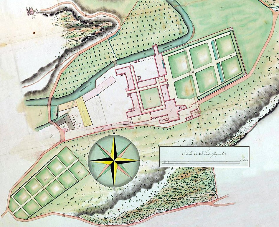
English: Map of the monastry of the Dominican Order in Marienthal, Duchy of Luxembourg, 1785. Lëtzebuergesch: Kaart vum Märjendaller Klouschter, 1785 wéi nach all d'Gebaier stoungen. Iwwerdauert als sollech hu wuel just den Haaptagank an eventuell de südleche Wutz vum Gebai 1, de vertikale Fligel vum Gebai 18, d'Gebaier 21 an 23, an de Yolanda-Tuerm. |
| Date |
Original map/Originalkaart: 1785 Derivative work/Beschafft: 2020-9-10 |
| Source |
Original map/Originalkaart: State Archives of Belgium Derivative work/Beschafft: Own work |
| Author |
Original map/Originalkaart: Visqué & J.-M. Boferding Derivative work/Beschafft: Otets at Luxembourgish Wikipedia |
| Permission (Reusing this file) |
Otets at Luxembourgish Wikipedia, the copyright holder of this work, hereby publishes it under the following license: This file is licensed under the Creative Commons Attribution-Share Alike 3.0 Luxembourg license. Attribution: Otets at Luxembourgish Wikipedia
 |
File history
Click on a date/time to view the file as it appeared at that time.
| Date/Time | Thumbnail | Dimensions | User | Comment | |
|---|---|---|---|---|---|
| current | 23:17, 9 September 2020 | | 1,487 × 1,206 (441 KB) | Otets (talk | contribs) | {{Information |description= |date= |source= |author= |permission= |other versions= }}{{Information | Description = {{en|1=Map of the monastry of the Dominican Order in Marienthal, Duchy of Luxembourg, 1785.}}{{lb|1=Kaart vum Märjendaller Klouschter, 1785 wéi nach all d'Gebaier stoungen. Iwwerdauert als sollech hu wuel just den Haaptagank an eventuell de südleche Wutz vum Gebai 1, de vertikale Fligel vum Gebai 18, d'Gebaier 21 an 23, an de Yolanda-Tuerm.}} | Source = Original map/Or... |
You cannot overwrite this file.
File usage on Commons
The following page uses this file:
File usage on other wikis
The following other wikis use this file:
- Usage on lb.wikipedia.org
.jpg&oldid=716585587)