File:MáximoAvanceDeLasUnidadesDeDEnikinOctubreDe1919.svg
Jump to navigation
Jump to search

Size of this PNG preview of this SVG file: 752 × 600 pixels. Other resolutions: 301 × 240 pixels | 602 × 480 pixels | 963 × 768 pixels | 1,280 × 1,021 pixels | 2,560 × 2,043 pixels | 2,617 × 2,088 pixels.
Original file (SVG file, nominally 2,617 × 2,088 pixels, file size: 206 KB)
Captions
Captions
Add a one-line explanation of what this file represents
Summary
[edit]
| Description |
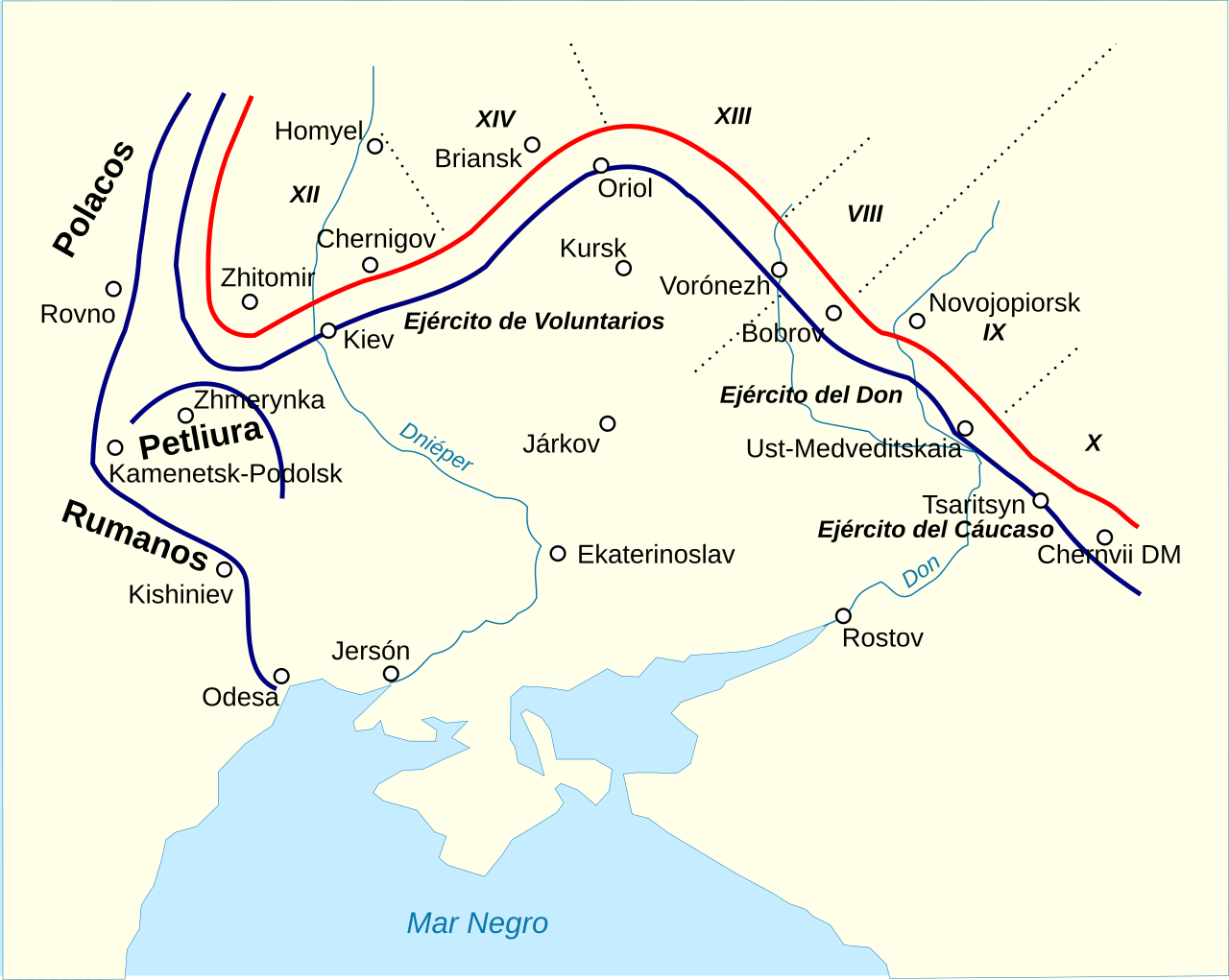
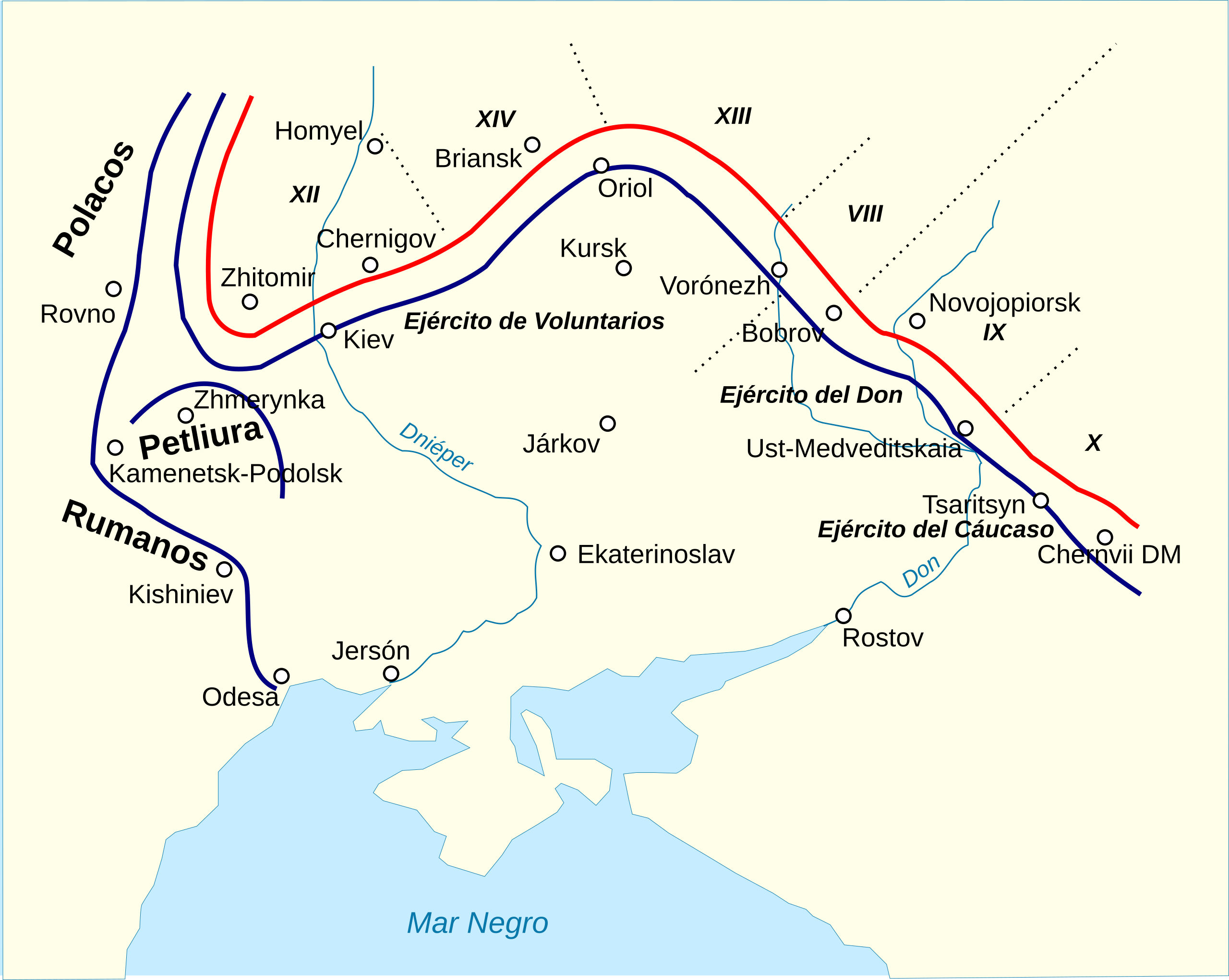
Español: Máximo avance de las fuerzas de Anton Denikin durante la ofensiva contra Moscú en el otoño de 1919.
English: Map showing maximum territories controlled by Armed Forces of South Russia. October 1919. |
| Date | (UTC) |
| Source |
This file was derived from: Max territories controlled by armed forces of southern russia (VSYR).jpg: |
| Author |
|
.jpg)
| This is a retouched picture, which means that it has been digitally altered from its original version. Modifications: turned into SVG and translated into Spanish. The original can be viewed here: Max territories controlled by armed forces of southern russia (VSYR).jpg:
|
Licensing
[edit]
This file is licensed under the Creative Commons Attribution-Share Alike 3.0 Unported license.
- You are free:
- to share – to copy, distribute and transmit the work
- to remix – to adapt the work
- Under the following conditions:
- attribution – You must give appropriate credit, provide a link to the license, and indicate if changes were made. You may do so in any reasonable manner, but not in any way that suggests the licensor endorses you or your use.
- share alike – If you remix, transform, or build upon the material, you must distribute your contributions under the same or compatible license as the original.
Original upload log
[edit]
This image is a derivative work of the following images:
- File:Max_territories_controlled_by_armed_forces_of_southern_russia_(VSYR).jpg licensed with PD-old
- 2011-09-17T15:00:58Z HOBOPOCC 2606x2339 (731222 Bytes) {{Information |Description ={{en|1=Map showing maximum territories controlled by Armed Forces of South Russia. October 1919.}} |Source =Book of A. Egorov Razgrom Denikina |Author =A. Egorov |Date
Uploaded with derivativeFX
File history
Click on a date/time to view the file as it appeared at that time.
| Date/Time | Thumbnail | Dimensions | User | Comment | |
|---|---|---|---|---|---|
| current | 07:59, 17 September 2019 | | 2,617 × 2,088 (206 KB) | Rowanwindwhistler (talk | contribs) | Fake text to improve rendering (real text hidden). |
| 20:51, 3 June 2016 |  | 2,617 × 2,088 (44 KB) | Rowanwindwhistler (talk | contribs) | https://en.wikipedia.org/wiki/Wikipedia:WikiProject_Maps/Conventions | |
| 10:49, 29 April 2012 |  | 2,617 × 2,088 (44 KB) | Rowanwindwhistler (talk | contribs) | == {{int:filedesc}} == {{Information |Description={{es|1=Máximo avance de las fuerzas de Anton Denikin durante la ofensiva contra Moscú en el otoño de 1919.}} {{en|1=Map showing maximum territories controlled by Armed Forces of South Russia. October... |
You cannot overwrite this file.
File usage on Commons
There are no pages that use this file.
File usage on other wikis
The following other wikis use this file:
- Usage on es.wikipedia.org
- Usage on ro.wikipedia.org