File:Luxembourg T1 2017 map-lb.svg
Jump to navigation
Jump to search

Size of this PNG preview of this SVG file: 634 × 600 pixels. Other resolutions: 254 × 240 pixels | 508 × 480 pixels | 812 × 768 pixels | 1,083 × 1,024 pixels | 2,165 × 2,048 pixels | 1,052 × 995 pixels.
Original file (SVG file, nominally 1,052 × 995 pixels, file size: 3.26 MB)
Captions
Captions
Add a one-line explanation of what this file represents
Summary
[edit]| Description |
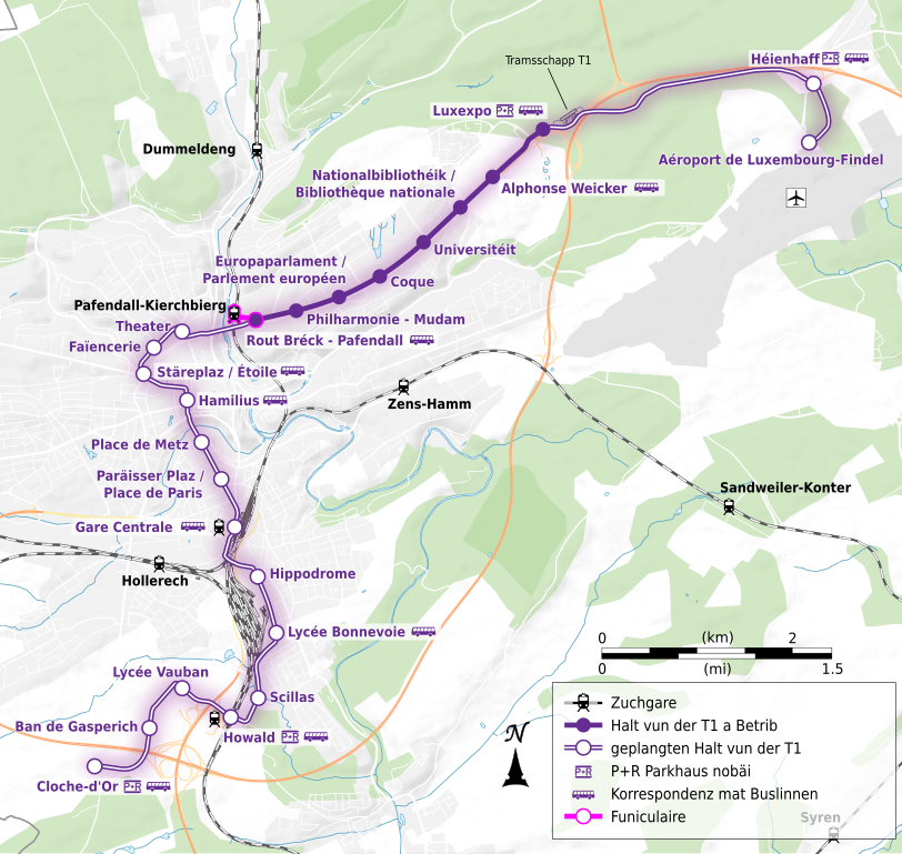
English: Luxembourgish map of the T1 tramway line of Luxembourg city from december 2017 to july 2018. |
| Date | |
| Source |
Own work from:
|
| Author | Flappiefh |
| Other versions |
|


Licensing
[edit]
I, the copyright holder of this work, hereby publish it under the following license:
This file is licensed under the Creative Commons Attribution-Share Alike 4.0 International license.
- You are free:
- to share – to copy, distribute and transmit the work
- to remix – to adapt the work
- Under the following conditions:
- attribution – You must give appropriate credit, provide a link to the license, and indicate if changes were made. You may do so in any reasonable manner, but not in any way that suggests the licensor endorses you or your use.
- share alike – If you remix, transform, or build upon the material, you must distribute your contributions under the same or compatible license as the original.
File history
Click on a date/time to view the file as it appeared at that time.
| Date/Time | Thumbnail | Dimensions | User | Comment | |
|---|---|---|---|---|---|
| current | 20:40, 12 February 2020 | | 1,052 × 995 (3.26 MB) | Flappiefh (talk | contribs) | Paräisser Plaz (et non Paraïsser Plaz) - merci à Zinneke pour la correction |
| 17:46, 11 February 2020 |  | 1,052 × 995 (3.26 MB) | Flappiefh (talk | contribs) | 2 modifications dans les noms de station : "Place de Metz" et "Paraïsser Plaz / Place de Paris". | |
| 20:51, 26 July 2018 |  | 1,052 × 995 (3.01 MB) | Flappiefh (talk | contribs) | User created page with UploadWizard |
You cannot overwrite this file.
File usage on Commons
The following 11 pages use this file:
- User:Chumwa/OgreBot/Potential transport maps/2018 July 21-31
- User:Chumwa/OgreBot/Public transport information/2018 July 21-31
- User:Chumwa/OgreBot/Public transport information/2020 February 10-19
- User:Chumwa/OgreBot/Transport Maps/2018 July 21-31
- User:Chumwa/OgreBot/Transport Maps/2020 February 10-19
- User:Chumwa/OgreBot/Travel and communication maps/2018 July 21-31
- User:Zinneke/Nei Biller iwwer Lëtzebuerg/2018 July 21-31
- User:Zinneke/Nei Biller iwwer Lëtzebuerg/2020 February 10-19
- File:Luxembourg T1 2017 map-de.svg
- File:Luxembourg T1 2017 map-fr.svg
- File:Luxembourg T1 2017 map-lb.svg