File:Lumeau.png
Jump to navigation
Jump to search
Size of this preview: 800 × 421 pixels. Other resolutions: 320 × 168 pixels | 640 × 337 pixels | 1,024 × 539 pixels | 1,486 × 782 pixels.
Original file (1,486 × 782 pixels, file size: 2.01 MB, MIME type: image/png)
Captions
Captions
Add a one-line explanation of what this file represents
Summary
[edit]
| Description |
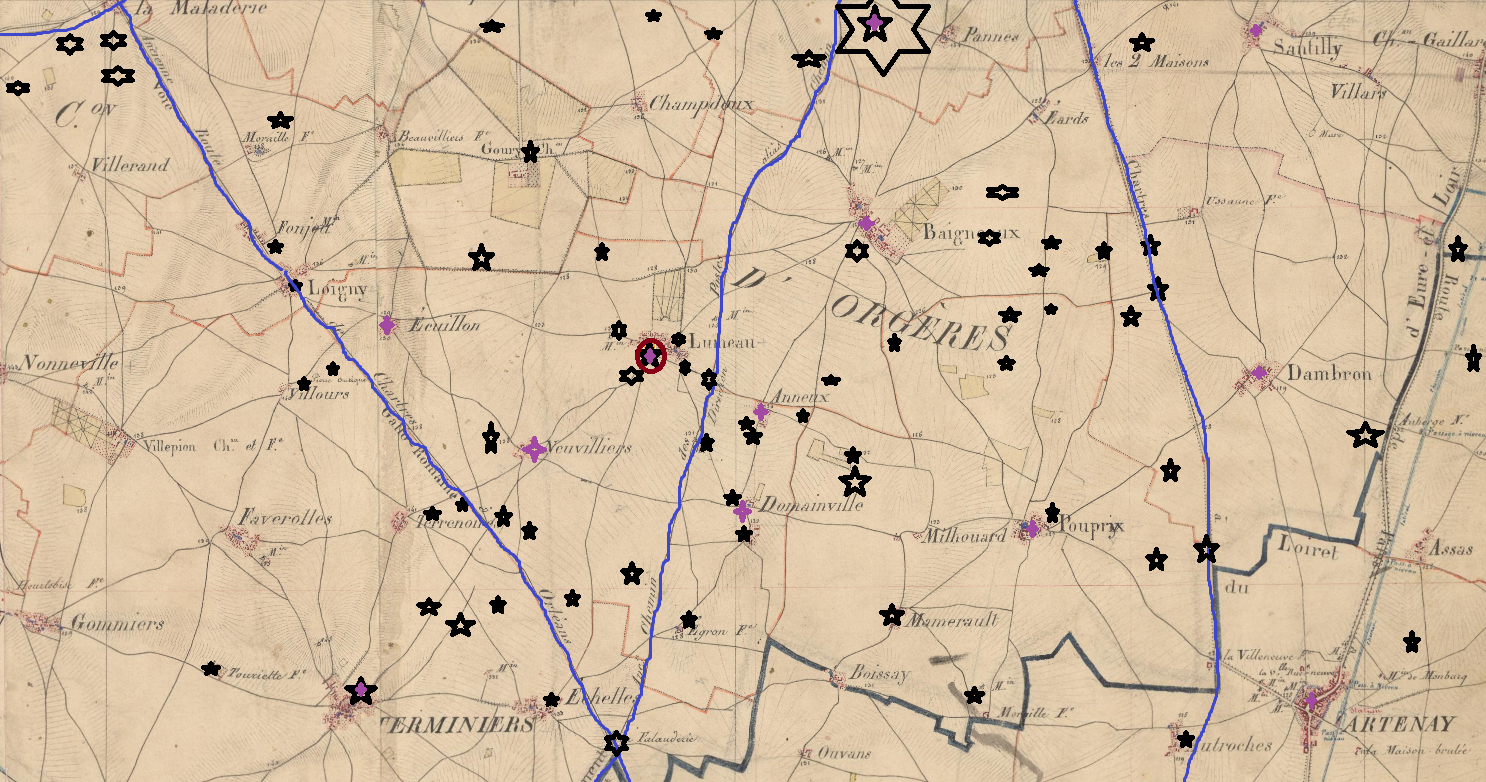
Français : Sur fond de carte d'Etat major de 1866 (source IGN), visualisation en lignes bleues des voies romaines et visualisation des sites d'occupation humaine entre l'âge de fer et le IIIe siècle EC (noir) et entre le IIIe et Ve siècle EC (violet) dans la commune de Lumeau (Eure-et-Loir, France) et alentour, avec des positionnements approximatifs adaptés de photographies aériennes et des informations publiques de la Carte géologique de la Gaule (Anne Ollagnier et al., 1994, ISBN 2-87764-032-4 Invalid ISBN pages 347 et 348) et de la figure 4 dans l'article d'Alain Ferdière, « La mise en place du réseau gallo-romain d'occupation du sol en Gaule centrale : Orléanais, Berry et Auvergne. », Revue archéologique de Picardie, no 11, 1996, p. 245-260.
English: Etat-Major map dated 1866 (source : Institut géographique national - IGN) + indication of sites with evidence of human occupancy from -100 BCE to 300 CE (black) and 300 CE to 500 CE (purple) in the region around commune de Lumeau, Eure-et-Loir, France. Own work derived from data gathered in Carte géologique de la Gaule (Anne Ollagnier et al., 1994, ISBN 2-87764-032-4 Invalid ISBN pages 347-348) and figure 4 in Alain Ferdière, « La mise en place du réseau gallo-romain d'occupation du sol en Gaule centrale : Orléanais, Berry et Auvergne. », Revue archéologique de Picardie, no 11, 1996, p. 245-260. |
| Date | |
| Source | Own work |
| Author | Hab Lumeau |
| Camera location | | View this and other nearby images on: OpenStreetMap |
|---|
Licensing
[edit]
I, the copyright holder of this work, hereby publish it under the following license:
This file is licensed under the Creative Commons Attribution-Share Alike 4.0 International license.
- You are free:
- to share – to copy, distribute and transmit the work
- to remix – to adapt the work
- Under the following conditions:
- attribution – You must give appropriate credit, provide a link to the license, and indicate if changes were made. You may do so in any reasonable manner, but not in any way that suggests the licensor endorses you or your use.
- share alike – If you remix, transform, or build upon the material, you must distribute your contributions under the same or compatible license as the original.
File history
Click on a date/time to view the file as it appeared at that time.
| Date/Time | Thumbnail | Dimensions | User | Comment | |
|---|---|---|---|---|---|
| current | 17:15, 10 October 2018 | | 1,486 × 782 (2.01 MB) | Hab Lumeau (talk | contribs) | corrections |
| 17:10, 10 October 2018 |  | 1,486 × 782 (2.01 MB) | Hab Lumeau (talk | contribs) | Correction site La Fortune | |
| 17:00, 10 October 2018 |  | 1,486 × 782 (2.01 MB) | Hab Lumeau (talk | contribs) | Corrections autour de Lumeau | |
| 16:52, 10 October 2018 |  | 1,486 × 782 (2.01 MB) | Hab Lumeau (talk | contribs) | Correction Mamerault | |
| 16:49, 10 October 2018 |  | 1,486 × 782 (2.01 MB) | Hab Lumeau (talk | contribs) | Corrections | |
| 16:41, 10 October 2018 |  | 1,486 × 782 (2.01 MB) | Hab Lumeau (talk | contribs) | Visualisations des sites établis entre -150 BCE et IIIe siècle (noir) et entre IIIe et le Ve siècles (violet) | |
| 16:25, 10 October 2018 |  | 1,486 × 782 (2.04 MB) | Hab Lumeau (talk | contribs) | User created page with UploadWizard |
You cannot overwrite this file.
File usage on Commons
There are no pages that use this file.
File usage on other wikis
The following other wikis use this file:
- Usage on fr.wikipedia.org