File:Luftwaffe DF Networks in the Mediterranean, middle of 1942.svg
Jump to navigation
Jump to search

Size of this PNG preview of this SVG file: 682 × 599 pixels. Other resolutions: 273 × 240 pixels | 546 × 480 pixels | 874 × 768 pixels | 1,165 × 1,024 pixels | 2,331 × 2,048 pixels | 1,121 × 985 pixels.
Original file (SVG file, nominally 1,121 × 985 pixels, file size: 786 KB)
Captions
Captions
Add a one-line explanation of what this file represents
Summary
[edit]
| Description |
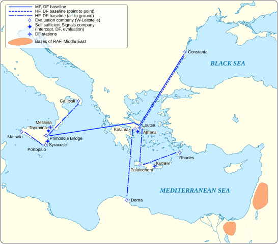
English: This diagram represents the organisation of a number of Luftwaffe High Frequency (HF) Direction-Finding (DF) baselines that were created by the Luftwaffe, that was in place in the eastern Mediterranean, in mid-1942. The HF DF network enabled the Luftwaffe to track Allied bombing raids in the Balkans, e.g. the Allied Liberator bombing attack on Ploiești that was sent to destroy the oil installations and infrastructure a year later on 1 July 1943. |
| Date | |
| Source |
Own work Information from: |
| Author | Goran tek-en, following request by Scope creep |
| Permission (Reusing this file) |
This file is licensed under the Creative Commons Attribution-Share Alike 4.0 International license. Attribution: Goran tek-en
|
| SVG development |
File history
Click on a date/time to view the file as it appeared at that time.
| Date/Time | Thumbnail | Dimensions | User | Comment | |
|---|---|---|---|---|---|
| current | 15:46, 25 December 2018 | | 1,121 × 985 (786 KB) | Goran tek-en (talk | contribs) | Updated positions of Kalamaki, Loutsa. |
| 18:09, 17 December 2018 |  | 1,121 × 985 (787 KB) | Goran tek-en (talk | contribs) | {{Information |description ={{en|1=This diagram represents the organisation of a number of Luftwaffe High Frequency (HF) Direction-Finding (DF) baselines that were created by the Luftwaffe, that was in place in the eastern Mediterranean, in mid-1942. The HF DF network enabled the Luftwaffe to track Allied bombing raids in the Balkans, e.g. the Allied Liberator bombing attack on Ploiești that was sent to destroy the oil installations and infrastructure a year later on 1 July 1943.}} |date... |
You cannot overwrite this file.
File usage on Commons
The following page uses this file:
File usage on other wikis
The following other wikis use this file:
- Usage on en.wikipedia.org