File:Lucien Lefort-ROUEN-Château d'eau-marégraphe-1885.jpg
Jump to navigation
Jump to search

Size of this preview: 800 × 600 pixels. Other resolutions: 320 × 240 pixels | 640 × 480 pixels | 1,024 × 768 pixels | 1,280 × 960 pixels | 2,560 × 1,920 pixels | 4,896 × 3,672 pixels.
Original file (4,896 × 3,672 pixels, file size: 6.77 MB, MIME type: image/jpeg)
Captions
Captions
Add a one-line explanation of what this file represents
Summary
[edit]
| Description |
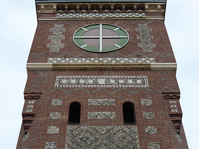
English: Cet ensemble est situé rive droite, à proximité du pont Guillaume le Conquérant, quai de Boisguilbert. Il est constitué du château d'eau / marégraphe, tour construite par Lucien Lefort en 1885 en brique industrielle, avec décorations en silex et calcaire, à toiture pyramidale. Aucun élément de machinerie ne subsiste à l'intérieur. Il comporte également le hangar n° 3 du modèle rive droite de 1884-85, construit vers 1900 sous forme d'un bâtiment à claire-voie. Sa structure métallique en poutrelles et grilles a été modifiée sans doute dès avant 1914. L'auvent situé côté Seine a été arasé. Un remplissage sud en brique est venu fermer la construction. Il comporte enfin le hangar n° 2 construit après 1918, à structure métallique et remplissage de brique.
www.google.fr/search?q=ROUEN-Ch%C3%A2teau+d%27eau-mar%C3%... www.pop.culture.gouv.fr/notice/merimee/PA76000030
|
|
| Date | ||
| Source | https://www.flickr.com/photos/jsebmaur/26072321383/ | |
| Author | jsmaur |
| Camera location | | View this and other nearby images on: OpenStreetMap |
|---|
Licensing
[edit]
This file is licensed under the Creative Commons Attribution-Share Alike 2.0 Generic license.
- You are free:
- to share – to copy, distribute and transmit the work
- to remix – to adapt the work
- Under the following conditions:
- attribution – You must give appropriate credit, provide a link to the license, and indicate if changes were made. You may do so in any reasonable manner, but not in any way that suggests the licensor endorses you or your use.
- share alike – If you remix, transform, or build upon the material, you must distribute your contributions under the same or compatible license as the original.
| This image was originally posted to Flickr by jsmaur at https://flickr.com/photos/70469209@N05/26072321383. It was reviewed on 27 September 2021 by FlickreviewR 2 and was confirmed to be licensed under the terms of the cc-by-sa-2.0. |

|
This image was uploaded as part of Wiki Loves Monuments 2021.
|
File history
Click on a date/time to view the file as it appeared at that time.
| Date/Time | Thumbnail | Dimensions | User | Comment | |
|---|---|---|---|---|---|
| current | 20:27, 27 September 2021 | | 4,896 × 3,672 (6.77 MB) | Jsebmaur (talk | contribs) | Uploaded a work by jsmaur from https://www.flickr.com/photos/jsebmaur/26072321383/ with UploadWizard |
You cannot overwrite this file.
File usage on Commons
There are no pages that use this file.